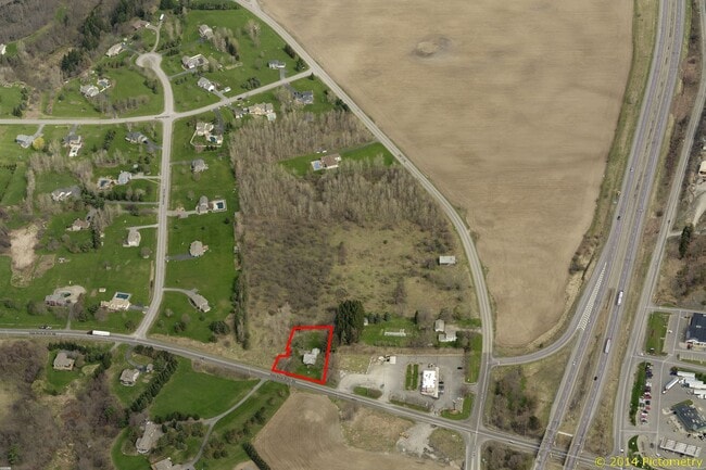
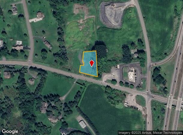
Property Record
5683 Route 80, Tully, NY 13159
NEARBY LISTINGS FOR SALE OR LEASE
-
-
View all Tully listings for sale on LoopNet.com
Property Detail
5683 Route 80
315489-121-000-0002-028-000-0000
FL 38 1020562
Residentialacreage
Onondaga
X
New York
36067C0470F
28.000
2025
0.71 AC
2024
W Outer Onondaga County
016901
Syracuse
1,884 SF
Syracuse, NY
DEMOGRAPHICS near 5683 Route 80
1 Mile
3 Mile
5 Mile
2024 Total Population
889
2,846
4,856
2029 Population
852
2,761
4,695
Pop Growth 2024-2029
(4.16%)
(2.99%)
(3.32%)
Average Age
44
44
44
2024 Total Households
388
1,187
1,987
HH Growth 2024-2029
(4.64%)
(3.20%)
(3.52%)
Median Household Inc
$70,609
$94,556
$95,346
Avg Household Size
2.20
2.40
2.40
2024 Avg HH Vehicles
2.00
2.00
2.00
Median Home Value
$205,357
$246,206
$233,949
Median Year Built
1959
1971
1971
Nearby Places
Map Layers
Map Styles
 Street
 Aerial
- Restaurants
- Banks
- Shops
- Fitness
- Groceries
PUBLIC TRANSPORTATION
AIRPORT
Syracuse Hancock International
DRIVE
WALK
Distance
Syracuse Hancock International
33 min
25.4 mi
Ithaca Tompkins International
DRIVE
WALK
Distance
Ithaca Tompkins International
50 min
33.5 mi
Freight Ports
Albany, NY Port
DRIVE
WALK
Distance
Albany, NY Port
192 min
162.8 mi
SALE & LEASE HISTORY
LISTING DATE
SALE/LEASE

Jun 02, 2020
For Sale
Nearby Properties
Address
Land Use
TOTAL SIZE
Lot Size
Zoning
Address
Land Use
TOTAL SIZE
Lot Size
Zoning
516,217 SF
136.80 AC
05 - COMME
Address
Land Use
TOTAL SIZE
Lot Size
Zoning
136,009 SF
17.95 AC
Address
Land Use
TOTAL SIZE
Lot Size
Zoning
92,759 SF
21.42 AC
R1
Address
Land Use
TOTAL SIZE
Lot Size
Zoning
4,308 SF
17.01 AC
R2
Address
Land Use
TOTAL SIZE
Lot Size
Zoning
12,110 SF
1.01 AC
R3
Address
Land Use
TOTAL SIZE
Lot Size
Zoning
59.95 AC
Address
Land Use
TOTAL SIZE
Lot Size
Zoning
12,894 SF
10.10 AC
R4
Address
Land Use
TOTAL SIZE
Lot Size
Zoning
218.61 AC
Address
Land Use
TOTAL SIZE
Lot Size
Zoning
115.25 AC
04 - FARM
Address
Land Use
TOTAL SIZE
Lot Size
Zoning
16,770 SF
5.75 AC
05 - COMME
Address
Land Use
TOTAL SIZE
Lot Size
Zoning
28,118 SF
33.58 AC
R5
Address
Land Use
TOTAL SIZE
Lot Size
Zoning
13,884 SF
1.74 AC
R5
Address
Land Use
TOTAL SIZE
Lot Size
Zoning
5,678 SF
3.01 AC
R5
Address
Land Use
TOTAL SIZE
Lot Size
Zoning
4.70 AC
Address
Land Use
TOTAL SIZE
Lot Size
Zoning
22,548 SF
7.62 AC
4
Address
Land Use
TOTAL SIZE
Lot Size
Zoning
18,240 SF
1.62 AC
R5
Address
Land Use
TOTAL SIZE
Lot Size
Zoning
500 SF
13.40 AC
Address
Land Use
TOTAL SIZE
Lot Size
Zoning
24,580 SF
5.15 AC
R4
Address
Land Use
TOTAL SIZE
Lot Size
Zoning
16,236 SF
217.06 AC
Address
Land Use
TOTAL SIZE
Lot Size
Zoning
240.54 AC
4
Address
Land Use
TOTAL SIZE
Lot Size
Zoning
4,968 SF
0.59 AC
R5
Address
Land Use
TOTAL SIZE
Lot Size
Zoning
1,600 SF
2.38 AC
04 - FARM
Address
Land Use
TOTAL SIZE
Lot Size
Zoning
308 SF
57.58 AC
05 - COMME
Address
Land Use
TOTAL SIZE
Lot Size
Zoning
1,600 SF
67.53 AC
04
Address
Land Use
TOTAL SIZE
Lot Size
Zoning
960 SF
23.91 AC
02
Address
Land Use
TOTAL SIZE
Lot Size
Zoning
12,135 SF
4.81 AC
05 - COMME
Address
Land Use
TOTAL SIZE
Lot Size
Zoning
3,955 SF
2.70 AC
04 - FARM
Address
Land Use
TOTAL SIZE
Lot Size
Zoning
590 SF
8.49 AC
Address
Land Use
TOTAL SIZE
Lot Size
Zoning
34,572 SF
1.83 AC
05 - COMME
Address
Land Use
TOTAL SIZE
Lot Size
Zoning
8,941 SF
18.93 AC
The World's #1 Commercial Real Estate Marketplace
Connect with us
© 2026 CoStar Group
The information above has been obtained from sources believed reliable. While we do not doubt its accuracy we have not verified it and make no guarantee, warranty or representation about it. It is your responsibility to independently confirm its accuracy and completeness. Any projections, opinions, assumptions, or estimates used are for example only and do not represent the current or future performance of the property. The value of this transaction to you depends on tax and other factors which should be evaluated by your tax, financial, and legal advisors. You and your advisors should conduct a careful, independent investigation of the property to determine to your satisfaction the suitability of the property for your needs.