Property Record
5685 W Cilma Dr, West Valley City, UT 84128


NEARBY LISTINGS FOR SALE OR LEASE
-
-
No Photo
-
View all West Valley City listings for sale on LoopNet.com
Property Detail
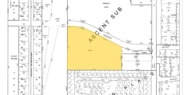
5685 W Cilma Dr
Salt Lake City, UT
Ascent Subdivision
14-35-428-024-0000
LOT 1, ASCENT SUBDIVISION. 10703-6900
Publicschool
Salt Lake
X
Utah
49035C0275G
1
0
5 AC
2025
West Valley/Lake Park
113409
Salt Lake City
27,616 SF
DEMOGRAPHICS near 5685 W Cilma Dr
1 Mile
3 Mile
5 Mile
2024 Total Population
16,145
120,806
256,913
2029 Population
16,199
121,343
259,548
Pop Growth 2024-2029
+ 0.33%
+ 0.44%
+ 1.03%
Average Age
36
35
35
2024 Total Households
4,344
33,121
74,707
HH Growth 2024-2029
+ 0.18%
+ 0.32%
+ 0.99%
Median Household Inc
$88,945
$80,477
$77,131
Avg Household Size
3.60
3.50
3.30
2024 Avg HH Vehicles
3.00
2.00
2.00
Median Home Value
$352,885
$337,923
$341,762
Median Year Built
1981
1978
1983
Nearby Places
Map Layers
Map Styles
 Street
 Aerial
- Restaurants
- Banks
- Shops
- Fitness
- Groceries
PUBLIC TRANSPORTATION
AIRPORT
Salt Lake City International
DRIVE
WALK
Distance
Salt Lake City International
14 min
9.0 mi
Freight Ports
Port of Stockton
DRIVE
WALK
Distance
Port of Stockton
708 min
691.4 mi
Nearby Properties
Address
Land Use
TOTAL SIZE
Lot Size
Zoning
Address
Land Use
TOTAL SIZE
Lot Size
Zoning
1,113,459 SF
80.09 AC
M
Address
Land Use
TOTAL SIZE
Lot Size
Zoning
329,306 SF
14.67 AC
5005
Address
Land Use
TOTAL SIZE
Lot Size
Zoning
432,730 SF
13.03 AC
R-M
Address
Land Use
TOTAL SIZE
Lot Size
Zoning
634,402 SF
32.29 AC
IP-M
Address
Land Use
TOTAL SIZE
Lot Size
Zoning
529,870 SF
13.35 AC
R-M
Address
Land Use
TOTAL SIZE
Lot Size
Zoning
832,383 SF
19.61 AC
IP-M
Address
Land Use
TOTAL SIZE
Lot Size
Zoning
289,725 SF
8.42 AC
1108
Address
Land Use
TOTAL SIZE
Lot Size
Zoning
250,027 SF
8.46 AC
PF
Address
Land Use
TOTAL SIZE
Lot Size
Zoning
387,633 SF
24 AC
M-1
Address
Land Use
TOTAL SIZE
Lot Size
Zoning
404,800 SF
24.62 AC
M
Address
Land Use
TOTAL SIZE
Lot Size
Zoning
186,337 SF
20 AC
1107
Address
Land Use
TOTAL SIZE
Lot Size
Zoning
496,431 SF
23.89 AC
IP-M
Address
Land Use
TOTAL SIZE
Lot Size
Zoning
449,868 SF
22.27 AC
M
Address
Land Use
TOTAL SIZE
Lot Size
Zoning
229,578 SF
27.42 AC
M--1
Address
Land Use
TOTAL SIZE
Lot Size
Zoning
198,063 SF
12.90 AC
M
Address
Land Use
TOTAL SIZE
Lot Size
Zoning
418,984 SF
21.65 AC
IP-M
Address
Land Use
TOTAL SIZE
Lot Size
Zoning
297,972 SF
45.67 AC
M
Address
Land Use
TOTAL SIZE
Lot Size
Zoning
159,381 SF
18.82 AC
1106
Address
Land Use
TOTAL SIZE
Lot Size
Zoning
131,500 SF
75.92 AC
R-1-10
Address
Land Use
TOTAL SIZE
Lot Size
Zoning
374,120 SF
22.16 AC
IP-M
Address
Land Use
TOTAL SIZE
Lot Size
Zoning
74,439 SF
27.33 AC
M
Address
Land Use
TOTAL SIZE
Lot Size
Zoning
545,061 SF
38.41 AC
M
Address
Land Use
TOTAL SIZE
Lot Size
Zoning
292,947 SF
16.05 AC
M
Address
Land Use
TOTAL SIZE
Lot Size
Zoning
107,985 SF
9.95 AC
C-2
Address
Land Use
TOTAL SIZE
Lot Size
Zoning
226,870 SF
43.45 AC
M
Address
Land Use
TOTAL SIZE
Lot Size
Zoning
71,093 SF
29.58 AC
PF
Address
Land Use
TOTAL SIZE
Lot Size
Zoning
163,276 SF
68.68 AC
M
Address
Land Use
TOTAL SIZE
Lot Size
Zoning
133,174 SF
51.71 AC
M-1
Address
Land Use
TOTAL SIZE
Lot Size
Zoning
244,871 SF
14.53 AC
4144
Address
Land Use
TOTAL SIZE
Lot Size
Zoning
261,005 SF
17.32 AC
M
The World's #1 Commercial Real Estate Marketplace
Connect with us
© 2026 CoStar Group
The information above has been obtained from sources believed reliable. While we do not doubt its accuracy we have not verified it and make no guarantee, warranty or representation about it. It is your responsibility to independently confirm its accuracy and completeness. Any projections, opinions, assumptions, or estimates used are for example only and do not represent the current or future performance of the property. The value of this transaction to you depends on tax and other factors which should be evaluated by your tax, financial, and legal advisors. You and your advisors should conduct a careful, independent investigation of the property to determine to your satisfaction the suitability of the property for your needs.