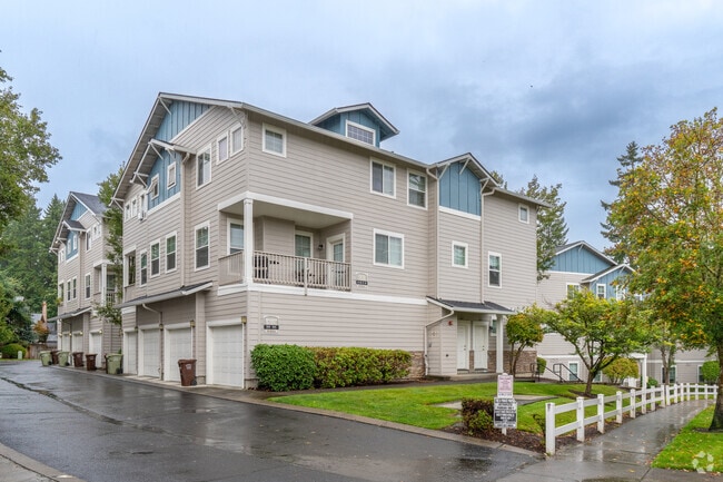
Property Record
5686 Nw 183Rd Ave, Unincorporated, OR 97226
Property Detail
5686 Nw 183Rd Ave
R2112744
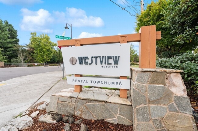
WESTVIEW HEIGHTS, LOT 6, ACRES 0.38
Apartment
WASHINGTON
R-24
Oregon
B and X Area of moderate flood hazard, usually the area between the limits of the 100-year and 500-year floods.
6
2024
0.35 AC
2026
Bethany
031509
Portland
12,740 SF
Portland-Vancouver-Hillsboro, OR-WA
NEARBY LISTINGS FOR SALE OR LEASE
-
-
View all Unincorporated listings for sale on LoopNet.com
DEMOGRAPHICS near 5686 Nw 183Rd Ave
1 mile
3 mile
5 mile
2025 Total Population
10,858
85,753
204,299
2030 Population
10,970
86,731
206,449
Pop Growth 2025-2030
+ 1.03%
+ 1.14%
+ 1.05%
Average Age
39
38
39
2025 Total Households
3,798
33,447
78,404
HH Growth 2025-2030
+ 1.11%
+ 1.20%
+ 1.15%
Median Household Inc
$141,277
$117,176
$113,724
Avg Household Size
2.80
2.50
2.60
2025 Avg HH Vehicles
2.00
2.00
2.00
Median Home Value
$712,005
$707,535
$653,929
Median Year Built
1994
1997
1996
Nearby Places
Map Layers
Map Styles
 Street
 Aerial
Transit
 Traffic
 Biking
Places
Listings with unknown addresses are not visible on the map
- Restaurants
- Banks
- Shops
- Fitness
- Groceries
PUBLIC TRANSPORTATION
COMMUTER RAIL
Beaverton Transit Center (West Side Express) (Westside Express Service - Tri-County Metropolitan Transportation District of Oregon Rail (TriMet Rail))
Drive
Walk
Distance
Beaverton Transit Center (West Side Express) (Westside Express Service - Tri-County Metropolitan Transportation District of Oregon Rail (TriMet Rail))
15 min
8.6 mi
AIRPORT
Portland International
Drive
Walk
Distance
Portland International
39 min
25.2 mi
Freight Ports
Port of Portland
Drive
Walk
Distance
Port of Portland
22 min
14.2 mi
Nearby Properties
Address
Land Use
TOTAL SIZE
Lot Size
Zoning
Address
Land Use
TOTAL SIZE
Lot Size
Zoning
21.21 AC
I-P
Address
Land Use
TOTAL SIZE
Lot Size
Zoning
0.13 AC
I-P
Address
Land Use
TOTAL SIZE
Lot Size
Zoning
337.91 AC
I-P
Address
Land Use
TOTAL SIZE
Lot Size
Zoning
562,350 SF
203.06 AC
INST
Address
Land Use
TOTAL SIZE
Lot Size
Zoning
37.93 AC
I-S
Address
Land Use
TOTAL SIZE
Lot Size
Zoning
373,884 SF
153.56 AC
UC-RP
Address
Land Use
TOTAL SIZE
Lot Size
Zoning
1,004,655 SF
24.55 AC
SCR-V
Address
Land Use
TOTAL SIZE
Lot Size
Zoning
Address
Land Use
TOTAL SIZE
Lot Size
Zoning
0.10 AC
IS
Address
Land Use
TOTAL SIZE
Lot Size
Zoning
Address
Land Use
TOTAL SIZE
Lot Size
Zoning
292,000 SF
53.23 AC
I-G
Address
Land Use
TOTAL SIZE
Lot Size
Zoning
0.03 AC
I-P
Address
Land Use
TOTAL SIZE
Lot Size
Zoning
316,321 SF
0.11 AC
I-P
Address
Land Use
TOTAL SIZE
Lot Size
Zoning
174,233 SF
14.74 AC
I-P
Address
Land Use
TOTAL SIZE
Lot Size
Zoning
791,581 SF
22.58 AC
MFR-3
Address
Land Use
TOTAL SIZE
Lot Size
Zoning
482,173 SF
14.99 AC
C-G
Address
Land Use
TOTAL SIZE
Lot Size
Zoning
281,183 SF
44.96 AC
R-5
Address
Land Use
TOTAL SIZE
Lot Size
Zoning
38.36 AC
I-P
Address
Land Use
TOTAL SIZE
Lot Size
Zoning
Address
Land Use
TOTAL SIZE
Lot Size
Zoning
29.94 AC
SID I-P
Address
Land Use
TOTAL SIZE
Lot Size
Zoning
22.13 AC
R-15
Address
Land Use
TOTAL SIZE
Lot Size
Zoning
495,454 SF
16.99 AC
SCR-V
Address
Land Use
TOTAL SIZE
Lot Size
Zoning
409,887 SF
20.03 AC
MFR-3
Address
Land Use
TOTAL SIZE
Lot Size
Zoning
71.43 AC
I-P
Address
Land Use
TOTAL SIZE
Lot Size
Zoning
210,649 SF
15.51 AC
R-15
Address
Land Use
TOTAL SIZE
Lot Size
Zoning
834,910 SF
14.87 AC
C-G
Address
Land Use
TOTAL SIZE
Lot Size
Zoning
360,916 SF
18.60 AC
MFR-2
Address
Land Use
TOTAL SIZE
Lot Size
Zoning
373,552 SF
13.19 AC
MFR-3
Address
Land Use
TOTAL SIZE
Lot Size
Zoning
155,788 SF
16.84 AC
R-6
Address
Land Use
TOTAL SIZE
Lot Size
Zoning
188,509 SF
17.27 AC
UC-OR
The World's #1 Commercial Real Estate Marketplace
Connect with us
© 2026 CoStar Group
The information above has been obtained from sources believed reliable. While we do not doubt its accuracy we have not verified it and make no guarantee, warranty or representation about it. It is your responsibility to independently confirm its accuracy and completeness. Any projections, opinions, assumptions, or estimates used are for example only and do not represent the current or future performance of the property. The value of this transaction to you depends on tax and other factors which should be evaluated by your tax, financial, and legal advisors. You and your advisors should conduct a careful, independent investigation of the property to determine to your satisfaction the suitability of the property for your needs.