Property Record
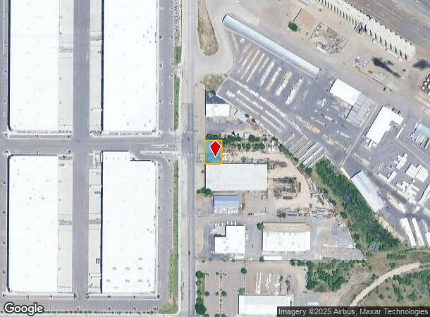
5686 Pecos St, Denver, CO 80221
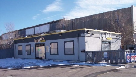

This Property Is For Sale
NEARBY LISTINGS FOR SALE OR LEASE
Property Detail
5686 Pecos St
1825-09-4-00-013
Carters Resub
Miscellaneous
SECT,TWN,RNG:9-3-68 DESC: BEG 695/1 FT N OF S4 COR SEC 9 TH E 141/61 FT TH N 95/40 FT TH W 141/61 FT TH S 97/70 FT M/L TO POB EXC W 30 FT EXC RD (2021000103491) 0/1598A
X
Adams
08059C0220F
Colorado
2024
0.16 AC
2025
Northwest
009553
Denver
1,500 SF
Denver-Aurora-Centennial, CO
DEMOGRAPHICS near 5686 Pecos St
1 mile
3 mile
5 mile
2024 Total Population
4,479
114,959
411,298
2029 Population
4,647
118,023
419,880
Pop Growth 2024-2029
+ 3.75%
+ 2.67%
+ 2.09%
Average Age
38
37
37
2024 Total Households
1,641
47,782
183,198
HH Growth 2024-2029
+ 3.53%
+ 2.56%
+ 2.04%
Median Household Inc
$91,240
$85,802
$76,034
Avg Household Size
2.70
2.30
2.10
2024 Avg HH Vehicles
3.00
2.00
2.00
Median Home Value
$484,641
$493,246
$474,681
Median Year Built
1962
1971
1973
Nearby Places
Map Layers
Map Styles
 Street
 Aerial
Transit
 Traffic
 Biking
Places
Listings with unknown addresses are not visible on the map
- Restaurants
- Banks
- Shops
- Fitness
- Groceries
PUBLIC TRANSPORTATION
COMMUTER RAIL
Pecos Junction Station Track 1 (Union Station to Westminster Station - Regional Transportation District, Union Station to Wheat Ridge Ward Station - Regional Transportation District)
Drive
Walk
Distance
Pecos Junction Station Track 1 (Union Station to Westminster Station - Regional Transportation District, Union Station to Wheat Ridge Ward Station - Regional Transportation District)
1 min
10 min
0.5 mi
Clear Creek - Federal Station Track 1 (Union Station to Wheat Ridge Ward Station - Regional Transportation District)
Drive
Walk
Distance
Clear Creek - Federal Station Track 1 (Union Station to Wheat Ridge Ward Station - Regional Transportation District)
5 min
1.8 mi
AIRPORT
Denver International
Drive
Walk
Distance
Denver International
32 min
24.4 mi
Freight Ports
Tulsa Port Of Catoosa
Drive
Walk
Distance
Tulsa Port Of Catoosa
729 min
709.9 mi
Nearby Properties
Address
Land Use
TOTAL SIZE
Lot Size
Zoning
Address
Land Use
TOTAL SIZE
Lot Size
Zoning
396,741 SF
8.12 AC
A1
Address
Land Use
TOTAL SIZE
Lot Size
Zoning
552,279 SF
2.22 AC
C-RX
Address
Land Use
TOTAL SIZE
Lot Size
Zoning
251,587 SF
2.58 AC
C-MX-5
Address
Land Use
TOTAL SIZE
Lot Size
Zoning
657,947 SF
5.02 AC
C-RX
Address
Land Use
TOTAL SIZE
Lot Size
Zoning
6,252 SF
1.05 AC
C-MX
Address
Land Use
TOTAL SIZE
Lot Size
Zoning
694,425 SF
1.92 AC
C-MX
Address
Land Use
TOTAL SIZE
Lot Size
Zoning
311,406 SF
1.74 AC
C-MX
Address
Land Use
TOTAL SIZE
Lot Size
Zoning
294,950 SF
6.91 AC
C-RX-12
Address
Land Use
TOTAL SIZE
Lot Size
Zoning
310,267 SF
1.69 AC
C-MX
Address
Land Use
TOTAL SIZE
Lot Size
Zoning
318,052 SF
2.73 AC
C-MX
Address
Land Use
TOTAL SIZE
Lot Size
Zoning
175,933 SF
0.82 AC
C-MX
Address
Land Use
TOTAL SIZE
Lot Size
Zoning
352,600 SF
18.21 AC
I-B
Address
Land Use
TOTAL SIZE
Lot Size
Zoning
187,817 SF
1.02 AC
C-MX
Address
Land Use
TOTAL SIZE
Lot Size
Zoning
162,639 SF
1.44 AC
C-MX
Address
Land Use
TOTAL SIZE
Lot Size
Zoning
1.64 AC
CMP
Address
Land Use
TOTAL SIZE
Lot Size
Zoning
185,265 SF
4.37 AC
G-MU
Address
Land Use
TOTAL SIZE
Lot Size
Zoning
860,132 SF
68.50 AC
R-5
Address
Land Use
TOTAL SIZE
Lot Size
Zoning
84,252 SF
0.37 AC
I-MX-8
Address
Land Use
TOTAL SIZE
Lot Size
Zoning
424,862 SF
32.28 AC
G-MU-3
Address
Land Use
TOTAL SIZE
Lot Size
Zoning
265,054 SF
1.39 AC
C-MX-5
Address
Land Use
TOTAL SIZE
Lot Size
Zoning
188,322 SF
1.56 AC
C-MX
Address
Land Use
TOTAL SIZE
Lot Size
Zoning
203,148 SF
1.36 AC
C-MX-5
Address
Land Use
TOTAL SIZE
Lot Size
Zoning
104,837 SF
0.72 AC
U-MS
Address
Land Use
TOTAL SIZE
Lot Size
Zoning
138,770 SF
4.64 AC
Address
Land Use
TOTAL SIZE
Lot Size
Zoning
117,534 SF
0.70 AC
C-MX
Address
Land Use
TOTAL SIZE
Lot Size
Zoning
3,188 SF
81.17 AC
I-B
Address
Land Use
TOTAL SIZE
Lot Size
Zoning
30,316 SF
0.85 AC
U-MS
Address
Land Use
TOTAL SIZE
Lot Size
Zoning
281,209 SF
1.66 AC
C-MX-12
Address
Land Use
TOTAL SIZE
Lot Size
Zoning
8.83 AC
I-B
Address
Land Use
TOTAL SIZE
Lot Size
Zoning
25,000 SF
40.42 AC
I-A
The World's #1 Commercial Real Estate Marketplace
Connect with us
© 2026 CoStar Group
The information above has been obtained from sources believed reliable. While we do not doubt its accuracy we have not verified it and make no guarantee, warranty or representation about it. It is your responsibility to independently confirm its accuracy and completeness. Any projections, opinions, assumptions, or estimates used are for example only and do not represent the current or future performance of the property. The value of this transaction to you depends on tax and other factors which should be evaluated by your tax, financial, and legal advisors. You and your advisors should conduct a careful, independent investigation of the property to determine to your satisfaction the suitability of the property for your needs.