Property Record
5688 E Ml Ave, Kalamazoo, MI 49048
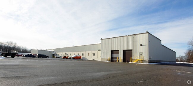

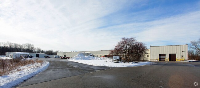
Property Detail
5688 E Ml Ave
07-30-405-013
SEC 30-2-10 COMMENCING AT THE SOUTH 1/4 POST, SECTION 30 T. 2 S., R. 10 W., COMSTOCK TOWNSHIP, KALAMAZOO COUNTY, MICHIGAN;
Industrialgeneral
Kalamazoo
LM
Michigan
B and X Area of moderate flood hazard, usually the area between the limits of the 100-year and 500-year floods.
33.12 AC
2025
Southern Kalamazoo County
2025
West Michigan
006702
Kalamazoo-Portage, MI
119,725 SF
NEARBY LISTINGS FOR SALE OR LEASE
-
-
-
-
-
-
-
I-94 Business Kalamazoo loop
Kalamazoo, MI 49001
$12.95 - $19.95 SF/YR
18,000 - 20,000 SF
Industrial
-
View all Kalamazoo listings for sale on LoopNet.com
DEMOGRAPHICS near 5688 E Ml Ave
1 mile
3 mile
5 mile
2025 Total Population
518
27,802
94,851
2030 Population
515
27,787
96,171
Pop Growth 2025-2030
(0.58%)
(0.05%)
+ 1.39%
Average Age
42
38
37
2025 Total Households
201
11,158
39,199
HH Growth 2025-2030
(0.50%)
(0.25%)
+ 1.53%
Median Household Inc
$66,724
$59,999
$57,374
Avg Household Size
2.40
2.40
2.20
2025 Avg HH Vehicles
2.00
2.00
2.00
Median Home Value
$183,720
$143,932
$176,054
Median Year Built
1960
1955
1960
Nearby Places
Map Layers
Map Styles
 Street
 Aerial
Transit
 Traffic
 Biking
Places
Listings with unknown addresses are not visible on the map
- Restaurants
- Banks
- Shops
- Fitness
- Groceries
PUBLIC TRANSPORTATION
COMMUTER RAIL
Drive
Walk
Distance
10 min
4.9 mi
AIRPORT
Kalamazoo/Battle Creek International
Drive
Walk
Distance
Kalamazoo/Battle Creek International
14 min
3.7 mi
Nearby Properties
Address
Land Use
TOTAL SIZE
Lot Size
Zoning
Address
Land Use
TOTAL SIZE
Lot Size
Zoning
82,520 SF
39.35 AC
I-1
Address
Land Use
TOTAL SIZE
Lot Size
Zoning
33.60 AC
Address
Land Use
TOTAL SIZE
Lot Size
Zoning
61.61 AC
Address
Land Use
TOTAL SIZE
Lot Size
Zoning
134,876 SF
16.45 AC
RM-15
Address
Land Use
TOTAL SIZE
Lot Size
Zoning
17,858 SF
15.27 AC
RM-1
Address
Land Use
TOTAL SIZE
Lot Size
Zoning
498,424 SF
41.72 AC
M-2
Address
Land Use
TOTAL SIZE
Lot Size
Zoning
298,908 SF
40.33 AC
Address
Land Use
TOTAL SIZE
Lot Size
Zoning
606,439 SF
34.61 AC
M-2
Address
Land Use
TOTAL SIZE
Lot Size
Zoning
Address
Land Use
TOTAL SIZE
Lot Size
Zoning
80,064 SF
6.13 AC
M-1
Address
Land Use
TOTAL SIZE
Lot Size
Zoning
157,123 SF
M
Address
Land Use
TOTAL SIZE
Lot Size
Zoning
793,429 SF
36.48 AC
M
Address
Land Use
TOTAL SIZE
Lot Size
Zoning
393,522 SF
33.31 AC
M-2
Address
Land Use
TOTAL SIZE
Lot Size
Zoning
98,401 SF
2.94 AC
RM-15
Address
Land Use
TOTAL SIZE
Lot Size
Zoning
129,350 SF
42.30 AC
I-1
Address
Land Use
TOTAL SIZE
Lot Size
Zoning
104,366 SF
9.76 AC
B-3
Address
Land Use
TOTAL SIZE
Lot Size
Zoning
10.04 AC
I-1
Address
Land Use
TOTAL SIZE
Lot Size
Zoning
49,894 SF
7.09 AC
RM-15
Address
Land Use
TOTAL SIZE
Lot Size
Zoning
183,820 SF
5.24 AC
CC
Address
Land Use
TOTAL SIZE
Lot Size
Zoning
142,198 SF
10 AC
Address
Land Use
TOTAL SIZE
Lot Size
Zoning
79,947 SF
12.13 AC
M
Address
Land Use
TOTAL SIZE
Lot Size
Zoning
69,987 SF
8.58 AC
RM-15
Address
Land Use
TOTAL SIZE
Lot Size
Zoning
2,286 SF
74.31 AC
Address
Land Use
TOTAL SIZE
Lot Size
Zoning
42,386 SF
1.55 AC
RM-15
Address
Land Use
TOTAL SIZE
Lot Size
Zoning
142,107 SF
14.97 AC
M-1
Address
Land Use
TOTAL SIZE
Lot Size
Zoning
10.76 AC
N/A
Address
Land Use
TOTAL SIZE
Lot Size
Zoning
478,944 SF
18.41 AC
M
Address
Land Use
TOTAL SIZE
Lot Size
Zoning
313,777 SF
15.30 AC
M-2
Address
Land Use
TOTAL SIZE
Lot Size
Zoning
80,640 SF
14.04 AC
Address
Land Use
TOTAL SIZE
Lot Size
Zoning
50,000 SF
17.50 AC
I-1
The World's #1 Commercial Real Estate Marketplace
Connect with us
© 2026 CoStar Group
The information above has been obtained from sources believed reliable. While we do not doubt its accuracy we have not verified it and make no guarantee, warranty or representation about it. It is your responsibility to independently confirm its accuracy and completeness. Any projections, opinions, assumptions, or estimates used are for example only and do not represent the current or future performance of the property. The value of this transaction to you depends on tax and other factors which should be evaluated by your tax, financial, and legal advisors. You and your advisors should conduct a careful, independent investigation of the property to determine to your satisfaction the suitability of the property for your needs.