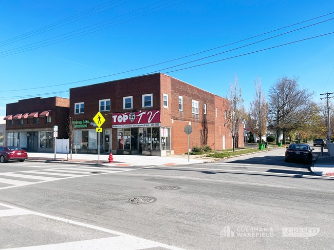
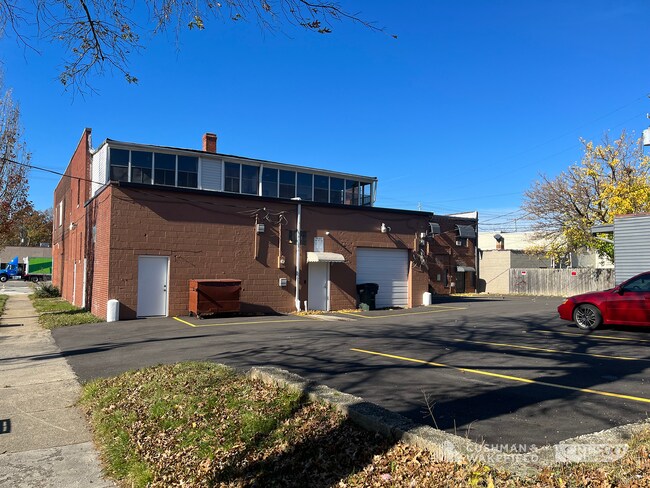
Property Record
569 E 185Th St, Cleveland, OH 44119

Property Detail
569 E 185Th St
641-13-004
17-17 RENWOOD 0002 ALL
Retailwithmorethanonenonretailuse
CUYAHOGA
U4
Ohio
B and X Area of moderate flood hazard, usually the area between the limits of the 100-year and 500-year floods.
2
2025
0.18 AC
2025
Northeast
152400
Cleveland
7,424 SF
Cleveland-Elyria, OH
NEARBY LISTINGS FOR SALE OR LEASE
DEMOGRAPHICS near 569 E 185Th St
1 mile
3 mile
5 mile
2025 Total Population
13,380
69,869
164,776
2030 Population
13,235
69,491
165,804
Pop Growth 2025-2030
(1.08%)
(0.54%)
+ 0.62%
Average Age
42
42
42
2025 Total Households
5,987
32,982
75,835
HH Growth 2025-2030
(1.29%)
(0.64%)
+ 0.60%
Median Household Inc
$52,528
$43,842
$48,356
Avg Household Size
2.10
2.00
2.10
2025 Avg HH Vehicles
1.00
1.00
1.00
Median Home Value
$126,832
$119,305
$141,351
Median Year Built
1948
1953
1954
Nearby Places
Map Layers
Map Styles
 Street
 Aerial
Transit
 Traffic
 Biking
Places
Listings with unknown addresses are not visible on the map
- Restaurants
- Banks
- Shops
- Fitness
- Groceries
PUBLIC TRANSPORTATION
AIRPORT
Cleveland-Hopkins International
Drive
Walk
Distance
Cleveland-Hopkins International
38 min
24.4 mi
SALE & LEASE HISTORY
LISTING DATE
SALE/LEASE

Nov 13, 2023
For Sale
Nearby Properties
Address
Land Use
TOTAL SIZE
Lot Size
Zoning
Address
Land Use
TOTAL SIZE
Lot Size
Zoning
63.59 AC
1F
Address
Land Use
TOTAL SIZE
Lot Size
Zoning
71.14 AC
U4
Address
Land Use
TOTAL SIZE
Lot Size
Zoning
44,577 SF
39.90 AC
SI
Address
Land Use
TOTAL SIZE
Lot Size
Zoning
386,776 SF
14.70 AC
CI
Address
Land Use
TOTAL SIZE
Lot Size
Zoning
112,657 SF
19.88 AC
U3
Address
Land Use
TOTAL SIZE
Lot Size
Zoning
19,776 SF
13.41 AC
CI
Address
Land Use
TOTAL SIZE
Lot Size
Zoning
450,285 SF
6.02 AC
LR
Address
Land Use
TOTAL SIZE
Lot Size
Zoning
2.53 AC
U6
Address
Land Use
TOTAL SIZE
Lot Size
Zoning
270,472 SF
5.92 AC
GR
Address
Land Use
TOTAL SIZE
Lot Size
Zoning
39.06 AC
U6
Address
Land Use
TOTAL SIZE
Lot Size
Zoning
275,040 SF
9.07 AC
U3
Address
Land Use
TOTAL SIZE
Lot Size
Zoning
10,200 SF
23.91 AC
Address
Land Use
TOTAL SIZE
Lot Size
Zoning
400,985 SF
34.80 AC
CI
Address
Land Use
TOTAL SIZE
Lot Size
Zoning
34.14 AC
U6
Address
Land Use
TOTAL SIZE
Lot Size
Zoning
27,466 SF
13.39 AC
U6
Address
Land Use
TOTAL SIZE
Lot Size
Zoning
827,164 SF
8 AC
U3
Address
Land Use
TOTAL SIZE
Lot Size
Zoning
70,574 SF
6.35 AC
CI
Address
Land Use
TOTAL SIZE
Lot Size
Zoning
70,643 SF
8.26 AC
CI
Address
Land Use
TOTAL SIZE
Lot Size
Zoning
358,547 SF
8.22 AC
U3EL
Address
Land Use
TOTAL SIZE
Lot Size
Zoning
127,630 SF
3.19 AC
MF-1
Address
Land Use
TOTAL SIZE
Lot Size
Zoning
339,686 SF
5.65 AC
2F
Address
Land Use
TOTAL SIZE
Lot Size
Zoning
70,953 SF
8.66 AC
CI
Address
Land Use
TOTAL SIZE
Lot Size
Zoning
251,689 SF
2.13 AC
LR
Address
Land Use
TOTAL SIZE
Lot Size
Zoning
23.92 AC
U6
Address
Land Use
TOTAL SIZE
Lot Size
Zoning
57.04 AC
Address
Land Use
TOTAL SIZE
Lot Size
Zoning
70,548 SF
5.97 AC
CI
Address
Land Use
TOTAL SIZE
Lot Size
Zoning
186,125 SF
11.95 AC
U6
Address
Land Use
TOTAL SIZE
Lot Size
Zoning
103,610 SF
4.58 AC
2F
Address
Land Use
TOTAL SIZE
Lot Size
Zoning
76,053 SF
5.03 AC
2F
Address
Land Use
TOTAL SIZE
Lot Size
Zoning
146,370 SF
9.82 AC
U6
The World's #1 Commercial Real Estate Marketplace
Connect with us
© 2026 CoStar Group
The information above has been obtained from sources believed reliable. While we do not doubt its accuracy we have not verified it and make no guarantee, warranty or representation about it. It is your responsibility to independently confirm its accuracy and completeness. Any projections, opinions, assumptions, or estimates used are for example only and do not represent the current or future performance of the property. The value of this transaction to you depends on tax and other factors which should be evaluated by your tax, financial, and legal advisors. You and your advisors should conduct a careful, independent investigation of the property to determine to your satisfaction the suitability of the property for your needs.