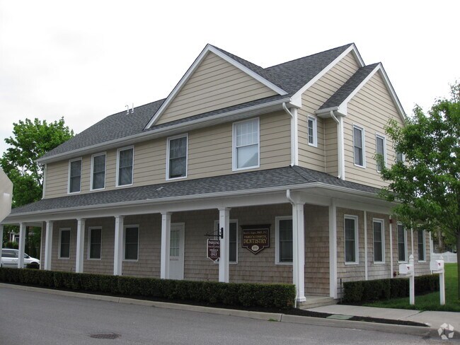
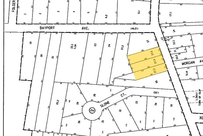
Property Record
569 Middle Rd, Bayport, NY 11705
NEARBY LISTINGS FOR SALE OR LEASE
Property Detail
569 Middle Rd
Nassau County-Suffolk County, NY
N068N00000000
0500-385-00-02-00-037-003
Suffolk
Commercialnec
New York
X
200
36103C0906H
0.30 AC
0
Central Suffolk
2024
Long Island (New York)
169903
DEMOGRAPHICS near 569 Middle Rd
1 Mile
3 Mile
5 Mile
2024 Total Population
6,765
53,144
112,728
2029 Population
6,674
52,653
111,605
Pop Growth 2024-2029
(1.35%)
(0.92%)
(1.00%)
Average Age
42
43
43
2024 Total Households
2,334
20,646
42,123
HH Growth 2024-2029
(1.54%)
(1.07%)
(1.15%)
Median Household Inc
$131,321
$113,473
$115,332
Avg Household Size
2.80
2.50
2.60
2024 Avg HH Vehicles
2.00
2.00
2.00
Median Home Value
$640,488
$517,953
$475,070
Median Year Built
1961
1969
1971
Nearby Places
Map Layers
Map Styles
 Street
 Aerial
- Restaurants
- Banks
- Shops
- Fitness
- Groceries
PUBLIC TRANSPORTATION
COMMUTER RAIL
Sayville Station (Montauk Branch - Long Island Rail Road)
DRIVE
WALK
Distance
Sayville Station (Montauk Branch - Long Island Rail Road)
6 min
2.2 mi
Patchogue Station (Montauk Branch - Long Island Rail Road)
DRIVE
WALK
Distance
Patchogue Station (Montauk Branch - Long Island Rail Road)
9 min
3.3 mi
AIRPORT
Long Island MacArthur
DRIVE
WALK
Distance
Long Island MacArthur
14 min
6.7 mi
Freight Ports
NY - Red Hook Container Terminal
DRIVE
WALK
Distance
NY - Red Hook Container Terminal
1 min
50.1 mi
Nearby Properties
Address
Land Use
TOTAL SIZE
Lot Size
Zoning
Address
Land Use
TOTAL SIZE
Lot Size
Zoning
27.90 AC
AA
Address
Land Use
TOTAL SIZE
Lot Size
Zoning
30.25 AC
CA
Address
Land Use
TOTAL SIZE
Lot Size
Zoning
33.47 AC
AA
Address
Land Use
TOTAL SIZE
Lot Size
Zoning
26.28 AC
CA
Address
Land Use
TOTAL SIZE
Lot Size
Zoning
27.63 AC
C
Address
Land Use
TOTAL SIZE
Lot Size
Zoning
218 AC
AAA
Address
Land Use
TOTAL SIZE
Lot Size
Zoning
26,811 SF
43.20 AC
CA
Address
Land Use
TOTAL SIZE
Lot Size
Zoning
7,290 SF
15.71 AC
CA
Address
Land Use
TOTAL SIZE
Lot Size
Zoning
8.65 AC
GSC
Address
Land Use
TOTAL SIZE
Lot Size
Zoning
20.29 AC
CA
Address
Land Use
TOTAL SIZE
Lot Size
Zoning
96 SF
18.29 AC
BUS3
Address
Land Use
TOTAL SIZE
Lot Size
Zoning
16 AC
AA
Address
Land Use
TOTAL SIZE
Lot Size
Zoning
27.10 AC
AAA
Address
Land Use
TOTAL SIZE
Lot Size
Zoning
3,025 SF
5.60 AC
AA
Address
Land Use
TOTAL SIZE
Lot Size
Zoning
23.90 AC
AA
Address
Land Use
TOTAL SIZE
Lot Size
Zoning
722 SF
24.39 AC
BUS3
Address
Land Use
TOTAL SIZE
Lot Size
Zoning
12.70 AC
IND1
Address
Land Use
TOTAL SIZE
Lot Size
Zoning
5.01 AC
AA278
Address
Land Use
TOTAL SIZE
Lot Size
Zoning
6.14 AC
Address
Land Use
TOTAL SIZE
Lot Size
Zoning
12.14 AC
BUS3
Address
Land Use
TOTAL SIZE
Lot Size
Zoning
14.73 AC
AA
Address
Land Use
TOTAL SIZE
Lot Size
Zoning
5,880 SF
2.10 AC
RWB
Address
Land Use
TOTAL SIZE
Lot Size
Zoning
15 AC
AA
Address
Land Use
TOTAL SIZE
Lot Size
Zoning
14.30 AC
B
Address
Land Use
TOTAL SIZE
Lot Size
Zoning
14.70 AC
BUS3
Address
Land Use
TOTAL SIZE
Lot Size
Zoning
17.52 AC
ICD
Address
Land Use
TOTAL SIZE
Lot Size
Zoning
9,148 SF
10.30 AC
CA
Address
Land Use
TOTAL SIZE
Lot Size
Zoning
17.90 AC
AAA
Address
Land Use
TOTAL SIZE
Lot Size
Zoning
14.75 AC
CA
Address
Land Use
TOTAL SIZE
Lot Size
Zoning
76.20 AC
AAA
The World's #1 Commercial Real Estate Marketplace
Connect with us
© 2026 CoStar Group
The information above has been obtained from sources believed reliable. While we do not doubt its accuracy we have not verified it and make no guarantee, warranty or representation about it. It is your responsibility to independently confirm its accuracy and completeness. Any projections, opinions, assumptions, or estimates used are for example only and do not represent the current or future performance of the property. The value of this transaction to you depends on tax and other factors which should be evaluated by your tax, financial, and legal advisors. You and your advisors should conduct a careful, independent investigation of the property to determine to your satisfaction the suitability of the property for your needs.