Property Record
569 S High St, Cortland, OH 44410

Save to a Folder
{{folder.Name}}
{{folder.ListingIds.length}} Properties
{{folder.ListingIds.length}} Property
Create a New Folder
Property Detail
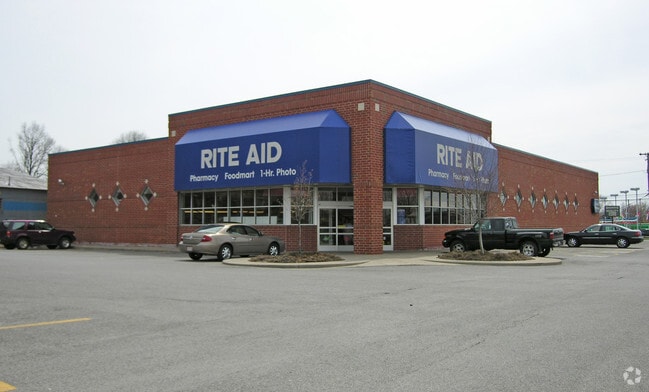
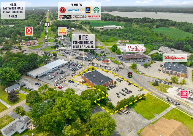
569 S High St
Youngstown-Warren, OH
REPLAT 1 316.32F PT MECCA ST 1.4648A
34-029300
Trumbull
Drugstorepharmacycvswalgreens
Ohio
B and X Area of moderate flood hazard, usually the area between the limits of the 100-year and 500-year floods.
1
2025
1.46 AC
2025
Trumbull County
930900
Youngstown/Warren/Boardman
11,388 SF
NEARBY LISTINGS FOR SALE OR LEASE
DEMOGRAPHICS near 569 S High St
1 mile
3 mile
5 mile
2025 Total Population
4,371
12,168
24,116
2030 Population
4,298
11,980
23,799
Pop Growth 2025-2030
(1.67%)
(1.55%)
(1.31%)
Average Age
43
45
46
2025 Total Households
1,850
5,363
10,508
HH Growth 2025-2030
(1.73%)
(1.58%)
(1.30%)
Median Household Inc
$64,828
$67,535
$67,721
Avg Household Size
2.30
2.20
2.20
2025 Avg HH Vehicles
2.00
2.00
2.00
Median Home Value
$223,326
$205,580
$196,318
Median Year Built
1983
1980
1977
Nearby Places
Map Layers
Map Styles
 Street
 Aerial
Layers
 Traffic
 Biking
Places
Listings with unknown addresses are not visible on the map
- Restaurants
- Banks
- Shops
- Fitness
- Groceries
SALE & LEASE HISTORY
LISTING DATE
SALE/LEASE

Aug 14, 2024
For Lease
Aug 14, 2024
For Sale
Nearby Properties
Address
Land Use
TOTAL SIZE
Lot Size
Zoning
Address
Land Use
TOTAL SIZE
Lot Size
Zoning
124,990 SF
11.44 AC
Address
Land Use
TOTAL SIZE
Lot Size
Zoning
2,891 SF
21.77 AC
Address
Land Use
TOTAL SIZE
Lot Size
Zoning
145,998 SF
32.90 AC
Address
Land Use
TOTAL SIZE
Lot Size
Zoning
27,241 SF
15.10 AC
Address
Land Use
TOTAL SIZE
Lot Size
Zoning
49.97 AC
Address
Land Use
TOTAL SIZE
Lot Size
Zoning
1,852.59 AC
Address
Land Use
TOTAL SIZE
Lot Size
Zoning
30,295 SF
8.18 AC
Address
Land Use
TOTAL SIZE
Lot Size
Zoning
21,681 SF
4.98 AC
Address
Land Use
TOTAL SIZE
Lot Size
Zoning
164,800 SF
33.73 AC
Address
Land Use
TOTAL SIZE
Lot Size
Zoning
14,736 SF
2.12 AC
Address
Land Use
TOTAL SIZE
Lot Size
Zoning
2,584 SF
1.25 AC
Address
Land Use
TOTAL SIZE
Lot Size
Zoning
20,046 SF
5.86 AC
Address
Land Use
TOTAL SIZE
Lot Size
Zoning
17,595 SF
20 AC
Address
Land Use
TOTAL SIZE
Lot Size
Zoning
3,456 SF
3.98 AC
Address
Land Use
TOTAL SIZE
Lot Size
Zoning
3,239 SF
8.58 AC
Address
Land Use
TOTAL SIZE
Lot Size
Zoning
12,060 SF
11.90 AC
Address
Land Use
TOTAL SIZE
Lot Size
Zoning
22,684 SF
5 AC
Address
Land Use
TOTAL SIZE
Lot Size
Zoning
10,844 SF
2.72 AC
Address
Land Use
TOTAL SIZE
Lot Size
Zoning
1,458 SF
16.04 AC
Address
Land Use
TOTAL SIZE
Lot Size
Zoning
4,271 SF
0.76 AC
Address
Land Use
TOTAL SIZE
Lot Size
Zoning
3,080 SF
107 AC
Address
Land Use
TOTAL SIZE
Lot Size
Zoning
1,798 SF
121.81 AC
Address
Land Use
TOTAL SIZE
Lot Size
Zoning
971.74 AC
Address
Land Use
TOTAL SIZE
Lot Size
Zoning
7,686 SF
1 AC
Address
Land Use
TOTAL SIZE
Lot Size
Zoning
Address
Land Use
TOTAL SIZE
Lot Size
Zoning
12,715 SF
2.50 AC
Address
Land Use
TOTAL SIZE
Lot Size
Zoning
16,965 SF
2.18 AC
Address
Land Use
TOTAL SIZE
Lot Size
Zoning
9,580 SF
17.37 AC
Address
Land Use
TOTAL SIZE
Lot Size
Zoning
13.98 AC
The World's #1 Commercial Real Estate Marketplace
Connect with us
© 2026 CoStar Group
The information above has been obtained from sources believed reliable. While we do not doubt its accuracy we have not verified it and make no guarantee, warranty or representation about it. It is your responsibility to independently confirm its accuracy and completeness. Any projections, opinions, assumptions, or estimates used are for example only and do not represent the current or future performance of the property. The value of this transaction to you depends on tax and other factors which should be evaluated by your tax, financial, and legal advisors. You and your advisors should conduct a careful, independent investigation of the property to determine to your satisfaction the suitability of the property for your needs.