Property Record
569 S Wilson Ave, Prichard, AL 36610
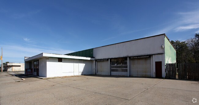

Property Detail
569 S Wilson Ave
Mobile, AL
LOT 1 & 2 BLK 1 SUB KNOWN AS SNUG HARBOR MBK 4 P 106- 109 LESS & EXCEPT ALL THAT PPTY LOC IN CITY OF PRICHARD TO WIT TO FIND
29-02-44-0-006-528.001
MOBILE
Autorepair
Alabama
B and X Area of moderate flood hazard, usually the area between the limits of the 100-year and 500-year floods.
1-2
2025
0.58 AC
2025
Midtown
007700
Mobile
5,888 SF
NEARBY LISTINGS FOR SALE OR LEASE
DEMOGRAPHICS near 569 S Wilson Ave
1 mile
3 mile
5 mile
2025 Total Population
8,998
50,688
107,608
2030 Population
9,419
52,073
109,088
Pop Growth 2025-2030
+ 4.68%
+ 2.73%
+ 1.38%
Average Age
43
41
40
2025 Total Households
3,524
20,740
44,167
HH Growth 2025-2030
+ 5.05%
+ 2.80%
+ 1.34%
Median Household Inc
$31,791
$34,687
$41,441
Avg Household Size
2.30
2.30
2.30
2025 Avg HH Vehicles
1.00
2.00
2.00
Median Home Value
$63,430
$82,036
$125,169
Median Year Built
1961
1963
1964
Nearby Places
Map Layers
Map Styles
 Street
 Aerial
Transit
 Traffic
 Biking
Places
Listings with unknown addresses are not visible on the map
- Restaurants
- Banks
- Shops
- Fitness
- Groceries
PUBLIC TRANSPORTATION
AIRPORT
Mobile International
Drive
Walk
Distance
Mobile International
16 min
7.0 mi
Mobile Regional
Drive
Walk
Distance
Mobile Regional
29 min
16.3 mi
Freight Ports
Port of Mobile
Drive
Walk
Distance
Port of Mobile
7 min
3.7 mi
SALE & LEASE HISTORY
LISTING DATE
SALE/LEASE

Nov 07, 2024
For Sale
Nearby Properties
Address
Land Use
TOTAL SIZE
Lot Size
Zoning
Address
Land Use
TOTAL SIZE
Lot Size
Zoning
410,802 SF
109.06 AC
Address
Land Use
TOTAL SIZE
Lot Size
Zoning
171,670 SF
20.19 AC
Address
Land Use
TOTAL SIZE
Lot Size
Zoning
339,141 SF
7.18 AC
Address
Land Use
TOTAL SIZE
Lot Size
Zoning
141,209 SF
10.20 AC
Address
Land Use
TOTAL SIZE
Lot Size
Zoning
128,384 SF
106.56 AC
Address
Land Use
TOTAL SIZE
Lot Size
Zoning
137,712 SF
61.95 AC
Address
Land Use
TOTAL SIZE
Lot Size
Zoning
30,504 SF
16.45 AC
Address
Land Use
TOTAL SIZE
Lot Size
Zoning
602,638 SF
85.74 AC
Address
Land Use
TOTAL SIZE
Lot Size
Zoning
153,780 SF
Address
Land Use
TOTAL SIZE
Lot Size
Zoning
334,636 SF
38 AC
Address
Land Use
TOTAL SIZE
Lot Size
Zoning
200,370 SF
47.96 AC
Address
Land Use
TOTAL SIZE
Lot Size
Zoning
91,391 SF
14.93 AC
Address
Land Use
TOTAL SIZE
Lot Size
Zoning
1,000 SF
33.20 AC
Address
Land Use
TOTAL SIZE
Lot Size
Zoning
7,505 SF
27.76 AC
Address
Land Use
TOTAL SIZE
Lot Size
Zoning
5,000 SF
13.33 AC
Address
Land Use
TOTAL SIZE
Lot Size
Zoning
12.97 AC
Address
Land Use
TOTAL SIZE
Lot Size
Zoning
103,308 SF
34 AC
Address
Land Use
TOTAL SIZE
Lot Size
Zoning
143,067 SF
9.62 AC
Address
Land Use
TOTAL SIZE
Lot Size
Zoning
66,936 SF
3.57 AC
Address
Land Use
TOTAL SIZE
Lot Size
Zoning
142,431 SF
10.12 AC
Address
Land Use
TOTAL SIZE
Lot Size
Zoning
5,553 SF
40.77 AC
Address
Land Use
TOTAL SIZE
Lot Size
Zoning
97,443 SF
98.83 AC
Address
Land Use
TOTAL SIZE
Lot Size
Zoning
107,777 SF
8.87 AC
Address
Land Use
TOTAL SIZE
Lot Size
Zoning
152,732 SF
7.70 AC
Address
Land Use
TOTAL SIZE
Lot Size
Zoning
10,400 SF
16 AC
Address
Land Use
TOTAL SIZE
Lot Size
Zoning
40,590 SF
9.30 AC
Address
Land Use
TOTAL SIZE
Lot Size
Zoning
6,360 SF
11.19 AC
Address
Land Use
TOTAL SIZE
Lot Size
Zoning
131,516 SF
15 AC
Address
Land Use
TOTAL SIZE
Lot Size
Zoning
105,896 SF
4.70 AC
Address
Land Use
TOTAL SIZE
Lot Size
Zoning
53,850 SF
12 AC
The World's #1 Commercial Real Estate Marketplace
Connect with us
© 2026 CoStar Group
The information above has been obtained from sources believed reliable. While we do not doubt its accuracy we have not verified it and make no guarantee, warranty or representation about it. It is your responsibility to independently confirm its accuracy and completeness. Any projections, opinions, assumptions, or estimates used are for example only and do not represent the current or future performance of the property. The value of this transaction to you depends on tax and other factors which should be evaluated by your tax, financial, and legal advisors. You and your advisors should conduct a careful, independent investigation of the property to determine to your satisfaction the suitability of the property for your needs.