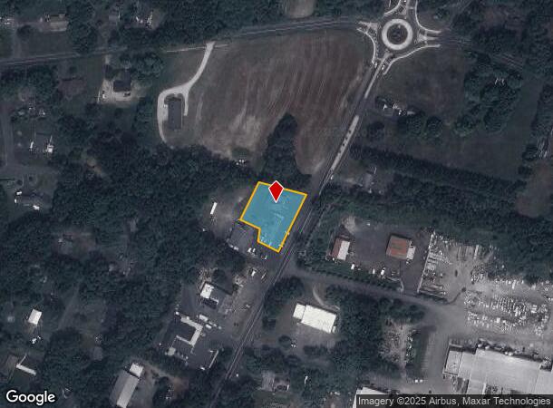
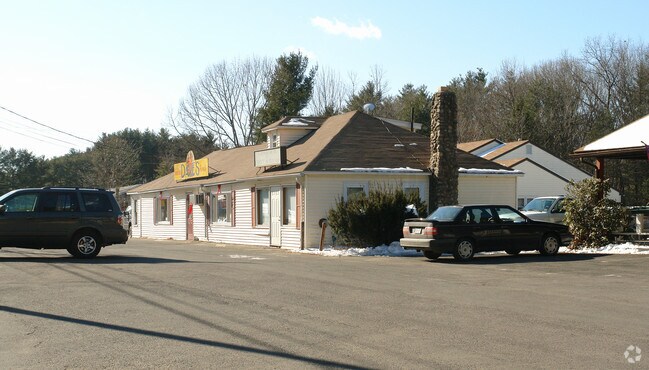
Property Record
569 Salmon Brook St, Granby, CT 06035

NEARBY LISTINGS FOR SALE OR LEASE
Property Detail
569 Salmon Brook St
GRAN-000042D-000027-000013
Hartford
Commercialnec
Connecticut
X
13
25013C0506E
0.81 AC
2025
Northwest Outlying
2025
Hartford
468101
Hartford-West Hartford-East Hartford, CT
DEMOGRAPHICS near 569 Salmon Brook St
1 Mile
3 Mile
5 Mile
2024 Total Population
1,472
9,108
21,381
2029 Population
1,459
9,042
21,225
Pop Growth 2024-2029
(0.88%)
(0.72%)
(0.73%)
Average Age
42
43
44
2024 Total Households
584
3,499
8,433
HH Growth 2024-2029
(1.03%)
(0.77%)
(0.79%)
Median Household Inc
$121,226
$116,415
$114,632
Avg Household Size
2.50
2.60
2.50
2024 Avg HH Vehicles
3.00
2.00
2.00
Median Home Value
$292,509
$338,574
$347,348
Median Year Built
1970
1973
1974
Nearby Places
Map Layers
Map Styles
 Street
 Aerial
- Restaurants
- Banks
- Shops
- Fitness
- Groceries
PUBLIC TRANSPORTATION
AIRPORT
Bradley International
DRIVE
WALK
Distance
Bradley International
25 min
10.1 mi
Freight Ports
Port of New Haven
DRIVE
WALK
Distance
Port of New Haven
78 min
53.5 mi
Nearby Properties
Address
Land Use
TOTAL SIZE
Lot Size
Zoning
Address
Land Use
TOTAL SIZE
Lot Size
Zoning
1,517 SF
45.69 AC
CC
Address
Land Use
TOTAL SIZE
Lot Size
Zoning
27.95 AC
CC
Address
Land Use
TOTAL SIZE
Lot Size
Zoning
58,477 SF
14.99 AC
R30
Address
Land Use
TOTAL SIZE
Lot Size
Zoning
8,509 SF
79.45 AC
R2A
Address
Land Use
TOTAL SIZE
Lot Size
Zoning
61,692 SF
12 AC
R50
Address
Land Use
TOTAL SIZE
Lot Size
Zoning
14.38 AC
CC
Address
Land Use
TOTAL SIZE
Lot Size
Zoning
5.96 AC
CO
Address
Land Use
TOTAL SIZE
Lot Size
Zoning
54,568 SF
11.74 AC
C2
Address
Land Use
TOTAL SIZE
Lot Size
Zoning
45,840 SF
3.46 AC
B
Address
Land Use
TOTAL SIZE
Lot Size
Zoning
12.98 AC
I
Address
Land Use
TOTAL SIZE
Lot Size
Zoning
12.98 AC
Address
Land Use
TOTAL SIZE
Lot Size
Zoning
2.70 AC
CO
Address
Land Use
TOTAL SIZE
Lot Size
Zoning
22.23 AC
R2A
Address
Land Use
TOTAL SIZE
Lot Size
Zoning
12,847 SF
2.25 AC
B
Address
Land Use
TOTAL SIZE
Lot Size
Zoning
16,543 SF
1.91 AC
R50
Address
Land Use
TOTAL SIZE
Lot Size
Zoning
1,819 SF
3.45 AC
B
Address
Land Use
TOTAL SIZE
Lot Size
Zoning
10,107 SF
1.40 AC
CO
Address
Land Use
TOTAL SIZE
Lot Size
Zoning
9,992 SF
31.41 AC
R-40
Address
Land Use
TOTAL SIZE
Lot Size
Zoning
2.89 AC
R30
Address
Land Use
TOTAL SIZE
Lot Size
Zoning
13,991 SF
2.08 AC
R30
Address
Land Use
TOTAL SIZE
Lot Size
Zoning
4.20 AC
CC
Address
Land Use
TOTAL SIZE
Lot Size
Zoning
13,243 SF
3.08 AC
CC
Address
Land Use
TOTAL SIZE
Lot Size
Zoning
5.16 AC
I
Address
Land Use
TOTAL SIZE
Lot Size
Zoning
5,568 SF
5.51 AC
R-40
Address
Land Use
TOTAL SIZE
Lot Size
Zoning
3,616 SF
1.70 AC
R-40
Address
Land Use
TOTAL SIZE
Lot Size
Zoning
4,015 SF
1.11 AC
B
Address
Land Use
TOTAL SIZE
Lot Size
Zoning
5,000 SF
3.36 AC
I
Address
Land Use
TOTAL SIZE
Lot Size
Zoning
4.30 AC
C2
Address
Land Use
TOTAL SIZE
Lot Size
Zoning
5.74 AC
CC
Address
Land Use
TOTAL SIZE
Lot Size
Zoning
3.88 AC
I
The World's #1 Commercial Real Estate Marketplace
Connect with us
© 2025 CoStar Group
The information above has been obtained from sources believed reliable. While we do not doubt its accuracy we have not verified it and make no guarantee, warranty or representation about it. It is your responsibility to independently confirm its accuracy and completeness. Any projections, opinions, assumptions, or estimates used are for example only and do not represent the current or future performance of the property. The value of this transaction to you depends on tax and other factors which should be evaluated by your tax, financial, and legal advisors. You and your advisors should conduct a careful, independent investigation of the property to determine to your satisfaction the suitability of the property for your needs.