Property Record
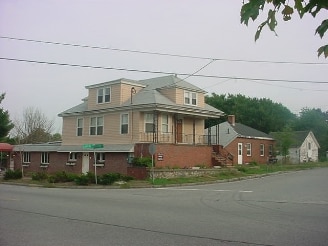
569 Winthrop St, Rehoboth, MA 02769


Property Detail
569 Winthrop St
REHO-000031-000000-000020
Bristol
Commercialofficeresidentialmixeduse
Massachusetts
B and X Area of moderate flood hazard, usually the area between the limits of the 100-year and 500-year floods.
0.91 AC
2025
Attleboro/New Bedford
2025
Boston
633200
Providence-Warwick, RI-MA
6,698 SF
NEARBY LISTINGS FOR SALE OR LEASE
DEMOGRAPHICS near 569 Winthrop St
1 mile
3 mile
5 mile
2025 Total Population
1,410
17,353
94,700
2030 Population
1,451
17,811
97,660
Pop Growth 2025-2030
+ 2.91%
+ 2.64%
+ 3.13%
Average Age
44
44
43
2025 Total Households
508
6,574
39,167
HH Growth 2025-2030
+ 2.95%
+ 2.63%
+ 3.16%
Median Household Inc
$115,870
$113,108
$88,441
Avg Household Size
2.80
2.60
2.40
2025 Avg HH Vehicles
2.00
2.00
2.00
Median Home Value
$588,353
$560,709
$415,396
Median Year Built
1970
1970
1957
Nearby Places
Map Layers
Map Styles
 Street
 Aerial
Layers
 Traffic
 Biking
Places
Listings with unknown addresses are not visible on the map
- Restaurants
- Banks
- Shops
- Fitness
- Groceries
PUBLIC TRANSPORTATION
COMMUTER RAIL
Providence (Providence/Stoughton Line - Massachusetts Bay Transportation Authority Commuter Rail (Purple Line))
Drive
Walk
Distance
Providence (Providence/Stoughton Line - Massachusetts Bay Transportation Authority Commuter Rail (Purple Line))
12 min
7.4 mi
Drive
Walk
Distance
14 min
7.6 mi
AIRPORT
Rhode Island Tf Green International
Drive
Walk
Distance
Rhode Island Tf Green International
25 min
13.8 mi
SALE & LEASE HISTORY
LISTING DATE
SALE/LEASE

Sep 25, 2016
For Lease
Sep 24, 2016
For Sale
Nov 08, 2022
For Lease
Jul 09, 2024
For Sale
Nearby Properties
Address
Land Use
TOTAL SIZE
Lot Size
Zoning
Address
Land Use
TOTAL SIZE
Lot Size
Zoning
47.75 AC
Address
Land Use
TOTAL SIZE
Lot Size
Zoning
171,290 SF
27.80 AC
R2
Address
Land Use
TOTAL SIZE
Lot Size
Zoning
126,183 SF
13.02 AC
HB
Address
Land Use
TOTAL SIZE
Lot Size
Zoning
132,452 SF
17.10 AC
HB
Address
Land Use
TOTAL SIZE
Lot Size
Zoning
101,598 SF
24.71 AC
R2
Address
Land Use
TOTAL SIZE
Lot Size
Zoning
121,346 SF
15.69 AC
LB
Address
Land Use
TOTAL SIZE
Lot Size
Zoning
71,585 SF
26.71 AC
R1
Address
Land Use
TOTAL SIZE
Lot Size
Zoning
10,296 SF
48.81 AC
R2
Address
Land Use
TOTAL SIZE
Lot Size
Zoning
30,824 SF
16.63 AC
R2MU
Address
Land Use
TOTAL SIZE
Lot Size
Zoning
46,512 SF
76.82 AC
R3
Address
Land Use
TOTAL SIZE
Lot Size
Zoning
46,512 SF
R3
Address
Land Use
TOTAL SIZE
Lot Size
Zoning
51,847 SF
9.74 AC
R2
Address
Land Use
TOTAL SIZE
Lot Size
Zoning
32,847 SF
178.99 AC
R4
Address
Land Use
TOTAL SIZE
Lot Size
Zoning
50,000 SF
3.45 AC
I3
Address
Land Use
TOTAL SIZE
Lot Size
Zoning
38,543 SF
42.84 AC
R4
Address
Land Use
TOTAL SIZE
Lot Size
Zoning
116,520 SF
7.41 AC
I3
Address
Land Use
TOTAL SIZE
Lot Size
Zoning
144,856 SF
8.87 AC
HB
Address
Land Use
TOTAL SIZE
Lot Size
Zoning
178 AC
Address
Land Use
TOTAL SIZE
Lot Size
Zoning
31,314 SF
76.82 AC
R3
Address
Land Use
TOTAL SIZE
Lot Size
Zoning
31,314 SF
76.82 AC
R3
Address
Land Use
TOTAL SIZE
Lot Size
Zoning
31,314 SF
76.82 AC
R3
Address
Land Use
TOTAL SIZE
Lot Size
Zoning
36,147 SF
2.95 AC
HB
Address
Land Use
TOTAL SIZE
Lot Size
Zoning
35,394 SF
6.21 AC
LB
Address
Land Use
TOTAL SIZE
Lot Size
Zoning
38,920 SF
30.31 AC
R2
Address
Land Use
TOTAL SIZE
Lot Size
Zoning
24,480 SF
1.44 AC
R3
Address
Land Use
TOTAL SIZE
Lot Size
Zoning
24,480 SF
76.82 AC
R3
Address
Land Use
TOTAL SIZE
Lot Size
Zoning
24,480 SF
76.82 AC
R3
Address
Land Use
TOTAL SIZE
Lot Size
Zoning
9,001 SF
158.50 AC
Address
Land Use
TOTAL SIZE
Lot Size
Zoning
19,794 SF
4.70 AC
HB
Address
Land Use
TOTAL SIZE
Lot Size
Zoning
2,926 SF
5.74 AC
R1
The World's #1 Commercial Real Estate Marketplace
Connect with us
© 2026 CoStar Group
The information above has been obtained from sources believed reliable. While we do not doubt its accuracy we have not verified it and make no guarantee, warranty or representation about it. It is your responsibility to independently confirm its accuracy and completeness. Any projections, opinions, assumptions, or estimates used are for example only and do not represent the current or future performance of the property. The value of this transaction to you depends on tax and other factors which should be evaluated by your tax, financial, and legal advisors. You and your advisors should conduct a careful, independent investigation of the property to determine to your satisfaction the suitability of the property for your needs.