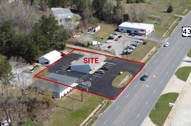
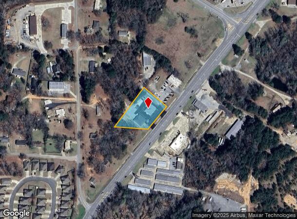
Property Record
5690 Highway 43 N, Northport, AL 35473
Current Lease Availabilities
NEARBY LISTINGS FOR SALE OR LEASE
Property Detail
5690 Highway 43 N
20-09-32-3-003-001.002
BEG 285(S) W OF SE COR NE OF SW; TH W 202.2(D)228(S); NE 126.5; NE 195; SE 195 TO RD SW ALG RD 195 TO POB; LYING IN S32 T20S R10W
Officebuilding
Tuscaloosa
X
Alabama
01125C0338G
1.26 AC
2025
Tuscaloosa
2024
Birmingham
010201
Tuscaloosa, AL
2,400 SF
DEMOGRAPHICS near 5690 Highway 43 N
1 Mile
3 Mile
5 Mile
2024 Total Population
2,557
22,274
69,980
2029 Population
2,809
24,723
77,818
Pop Growth 2024-2029
+ 9.86%
+ 10.99%
+ 11.20%
Average Age
41
41
36
2024 Total Households
1,043
8,443
24,840
HH Growth 2024-2029
+ 9.59%
+ 10.91%
+ 13.21%
Median Household Inc
$91,964
$77,470
$63,475
Avg Household Size
2.40
2.40
2.30
2024 Avg HH Vehicles
2.00
2.00
2.00
Median Home Value
$212,304
$197,452
$252,154
Median Year Built
1998
1991
1990
Nearby Places
- Restaurants
- Banks
- Shops
- Fitness
- Groceries
PUBLIC TRANSPORTATION
COMMUTER RAIL
Tuscaloosa Amtrak Station (Crescent - Amtrak)
DRIVE
WALK
Distance
Tuscaloosa Amtrak Station (Crescent - Amtrak)
10 min
5.9 mi
Freight Ports
Port of Mobile
DRIVE
WALK
Distance
Port of Mobile
246 min
204.7 mi
Nearby Properties
Address
Land Use
TOTAL SIZE
Lot Size
Zoning
Address
Land Use
TOTAL SIZE
Lot Size
Zoning
121,384 SF
21 AC
O-I
Address
Land Use
TOTAL SIZE
Lot Size
Zoning
20,224 SF
19 AC
RM2
Address
Land Use
TOTAL SIZE
Lot Size
Zoning
32,640 SF
9.80 AC
C6
Address
Land Use
TOTAL SIZE
Lot Size
Zoning
143,038 SF
36 AC
O-I
Address
Land Use
TOTAL SIZE
Lot Size
Zoning
208,996 SF
25 AC
C-6
Address
Land Use
TOTAL SIZE
Lot Size
Zoning
140,412 SF
14.35 AC
C6
Address
Land Use
TOTAL SIZE
Lot Size
Zoning
211,838 SF
11.71 AC
ML
Address
Land Use
TOTAL SIZE
Lot Size
Zoning
16,920 SF
6.84 AC
AG
Address
Land Use
TOTAL SIZE
Lot Size
Zoning
8,952 SF
5 AC
RM2
Address
Land Use
TOTAL SIZE
Lot Size
Zoning
47,657 SF
9.53 AC
C-3
Address
Land Use
TOTAL SIZE
Lot Size
Zoning
11,244 SF
5.60 AC
RM2
Address
Land Use
TOTAL SIZE
Lot Size
Zoning
17,304 SF
7.20 AC
C6
Address
Land Use
TOTAL SIZE
Lot Size
Zoning
7,208 SF
6.10 AC
RM2
Address
Land Use
TOTAL SIZE
Lot Size
Zoning
43,320 SF
5.30 AC
C-6
Address
Land Use
TOTAL SIZE
Lot Size
Zoning
41,065 SF
5.87 AC
C-6
Address
Land Use
TOTAL SIZE
Lot Size
Zoning
437 SF
117 AC
I
Address
Land Use
TOTAL SIZE
Lot Size
Zoning
19,071 SF
1.79 AC
O-I
Address
Land Use
TOTAL SIZE
Lot Size
Zoning
1,019 SF
12 AC
MHP
Address
Land Use
TOTAL SIZE
Lot Size
Zoning
17,166 SF
44 SF
O-I
Address
Land Use
TOTAL SIZE
Lot Size
Zoning
14,400 SF
5.20 AC
RS-1
Address
Land Use
TOTAL SIZE
Lot Size
Zoning
25,486 SF
44 SF
O-I
Address
Land Use
TOTAL SIZE
Lot Size
Zoning
82,656 SF
8 AC
C6
Address
Land Use
TOTAL SIZE
Lot Size
Zoning
37,553 SF
12 AC
O-I
Address
Land Use
TOTAL SIZE
Lot Size
Zoning
1,800 SF
8.10 AC
ML
Address
Land Use
TOTAL SIZE
Lot Size
Zoning
36,151 SF
5.10 AC
C-6
Address
Land Use
TOTAL SIZE
Lot Size
Zoning
4,306 SF
4.60 AC
OI
Address
Land Use
TOTAL SIZE
Lot Size
Zoning
2,000 SF
3.09 AC
C-3
Address
Land Use
TOTAL SIZE
Lot Size
Zoning
25,451 SF
4.32 AC
C-3
Address
Land Use
TOTAL SIZE
Lot Size
Zoning
46,201 SF
5.10 AC
O-I
Address
Land Use
TOTAL SIZE
Lot Size
Zoning
8,448 SF
4.50 AC
RM2
The World's #1 Commercial Real Estate Marketplace
Connect with us
© 2025 CoStar Group
The information above has been obtained from sources believed reliable. While we do not doubt its accuracy we have not verified it and make no guarantee, warranty or representation about it. It is your responsibility to independently confirm its accuracy and completeness. Any projections, opinions, assumptions, or estimates used are for example only and do not represent the current or future performance of the property. The value of this transaction to you depends on tax and other factors which should be evaluated by your tax, financial, and legal advisors. You and your advisors should conduct a careful, independent investigation of the property to determine to your satisfaction the suitability of the property for your needs.