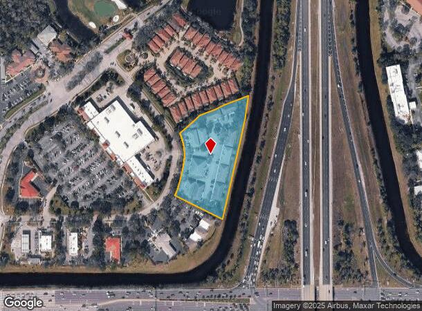
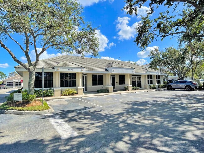
Property Record
5650 Strand Ct, Naples, FL 34110

NEARBY LISTINGS FOR SALE OR LEASE
Property Detail
5650 Strand Ct
Naples-Marco Island, FL
Strand Professional
74980000020
Collier
Condominium
Florida
X
North Naples
12021C0213H
Southwest Florida
2,939 SF
DEMOGRAPHICS near 5650 Strand Ct
1 Mile
3 Mile
5 Mile
2024 Total Population
7,643
50,002
132,282
2029 Population
8,635
56,289
151,459
Pop Growth 2024-2029
+ 12.98%
+ 12.57%
+ 14.50%
Average Age
51
50
50
2024 Total Households
3,670
21,996
58,470
HH Growth 2024-2029
+ 12.59%
+ 12.24%
+ 14.19%
Median Household Inc
$62,875
$84,347
$85,608
Avg Household Size
2.00
2.20
2.20
2024 Avg HH Vehicles
1.00
2.00
2.00
Median Home Value
$379,243
$477,438
$474,579
Median Year Built
2000
2000
1999
Nearby Places
Map Layers
Map Styles
 Street
 Aerial
- Restaurants
- Banks
- Shops
- Fitness
- Groceries
PUBLIC TRANSPORTATION
AIRPORT
Southwest Florida International
DRIVE
WALK
Distance
Southwest Florida International
23 min
20.5 mi
Freight Ports
Port Everglades
DRIVE
WALK
Distance
Port Everglades
1 min
101.0 mi
SALE & LEASE HISTORY
LISTING DATE
SALE/LEASE

Nov 18, 2022
For Lease
Feb 17, 2017
For Lease
Nearby Properties
Address
Land Use
TOTAL SIZE
Lot Size
Zoning
Address
Land Use
TOTAL SIZE
Lot Size
Zoning
377,883 SF
20.34 AC
PUD
Address
Land Use
TOTAL SIZE
Lot Size
Zoning
325,993 SF
35.92 AC
A
Address
Land Use
TOTAL SIZE
Lot Size
Zoning
463,985 SF
28.48 AC
Address
Land Use
TOTAL SIZE
Lot Size
Zoning
110,908 SF
210.45 AC
A
Address
Land Use
TOTAL SIZE
Lot Size
Zoning
413,313 SF
48.48 AC
PUD
Address
Land Use
TOTAL SIZE
Lot Size
Zoning
376,493 SF
65.03 AC
RSF-3
Address
Land Use
TOTAL SIZE
Lot Size
Zoning
353,756 SF
23.26 AC
ROAD
Address
Land Use
TOTAL SIZE
Lot Size
Zoning
292,967 SF
13.12 AC
PUD
Address
Land Use
TOTAL SIZE
Lot Size
Zoning
426,074 SF
23.25 AC
PUD
Address
Land Use
TOTAL SIZE
Lot Size
Zoning
87,499 SF
4.36 AC
Address
Land Use
TOTAL SIZE
Lot Size
Zoning
174,770 SF
3.65 AC
PUD
Address
Land Use
TOTAL SIZE
Lot Size
Zoning
192,347 SF
7.84 AC
PUD
Address
Land Use
TOTAL SIZE
Lot Size
Zoning
174,365 SF
18.56 AC
PUD
Address
Land Use
TOTAL SIZE
Lot Size
Zoning
188,741 SF
9.04 AC
A
Address
Land Use
TOTAL SIZE
Lot Size
Zoning
128,681 SF
49.55 AC
A
Address
Land Use
TOTAL SIZE
Lot Size
Zoning
223,844 SF
27.55 AC
PUD
Address
Land Use
TOTAL SIZE
Lot Size
Zoning
329,031 SF
20 AC
A
Address
Land Use
TOTAL SIZE
Lot Size
Zoning
106,929 SF
23.05 AC
A
Address
Land Use
TOTAL SIZE
Lot Size
Zoning
104,317 SF
20 AC
PUD
Address
Land Use
TOTAL SIZE
Lot Size
Zoning
145,881 SF
142.48 AC
PUD
Address
Land Use
TOTAL SIZE
Lot Size
Zoning
86,254 SF
18.57 AC
A
Address
Land Use
TOTAL SIZE
Lot Size
Zoning
209,373 SF
23.76 AC
PUD
Address
Land Use
TOTAL SIZE
Lot Size
Zoning
52,370 SF
7.82 AC
PUD
Address
Land Use
TOTAL SIZE
Lot Size
Zoning
175,337 SF
14.61 AC
MPUD
Address
Land Use
TOTAL SIZE
Lot Size
Zoning
75,307 SF
2.49 AC
Address
Land Use
TOTAL SIZE
Lot Size
Zoning
81,202 SF
183.18 AC
GC
Address
Land Use
TOTAL SIZE
Lot Size
Zoning
52,150 SF
136.13 AC
PUD
Address
Land Use
TOTAL SIZE
Lot Size
Zoning
98,809 SF
18 AC
PUD
Address
Land Use
TOTAL SIZE
Lot Size
Zoning
81,890 SF
5.14 AC
PUD
Address
Land Use
TOTAL SIZE
Lot Size
Zoning
46,282 SF
5.25 AC
The World's #1 Commercial Real Estate Marketplace
Connect with us
© 2026 CoStar Group
The information above has been obtained from sources believed reliable. While we do not doubt its accuracy we have not verified it and make no guarantee, warranty or representation about it. It is your responsibility to independently confirm its accuracy and completeness. Any projections, opinions, assumptions, or estimates used are for example only and do not represent the current or future performance of the property. The value of this transaction to you depends on tax and other factors which should be evaluated by your tax, financial, and legal advisors. You and your advisors should conduct a careful, independent investigation of the property to determine to your satisfaction the suitability of the property for your needs.