Property Record
57 Beach St, Ogunquit, ME 03907
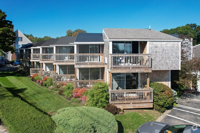

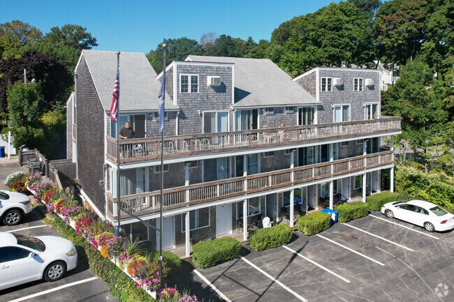
Property Detail
57 Beach St
OGUN-000007-000077-000078
York
Commercialnec
Maine
SLC
77
AE The base floodplain where base flood elevations are provided. AE Zones are now used on new format FIRMs instead of A1-A30 Zones.
1.43 AC
2025
York County
2025
Portland/South Portland
034006
Portland-South Portland, ME
NEARBY LISTINGS FOR SALE OR LEASE
-
-
View all Ogunquit listings for sale on LoopNet.com
DEMOGRAPHICS near 57 Beach St
1 mile
3 mile
5 mile
2025 Total Population
790
4,920
10,780
2030 Population
747
5,107
11,304
Pop Growth 2025-2030
(5.44%)
+ 3.80%
+ 4.86%
Average Age
58
53
51
2025 Total Households
418
2,374
4,990
HH Growth 2025-2030
(5.74%)
+ 3.62%
+ 4.83%
Median Household Inc
$121,874
$103,728
$101,795
Avg Household Size
1.90
2.10
2.10
2025 Avg HH Vehicles
2.00
2.00
2.00
Median Home Value
$830,487
$699,573
$662,530
Median Year Built
1980
1984
1984
Nearby Places
Map Layers
Map Styles
 Street
 Aerial
Layers
 Traffic
 Biking
Places
Listings with unknown addresses are not visible on the map
- Restaurants
- Banks
- Shops
- Fitness
- Groceries
PUBLIC TRANSPORTATION
COMMUTER RAIL
Wells (Downeaster - Amtrak)
Drive
Walk
Distance
Wells (Downeaster - Amtrak)
15 min
6.5 mi
AIRPORT
Portsmouth International at Pease
Drive
Walk
Distance
Portsmouth International at Pease
31 min
18.6 mi
Freight Ports
Portland, ME
Drive
Walk
Distance
Portland, ME
50 min
37.2 mi
Nearby Properties
Address
Land Use
TOTAL SIZE
Lot Size
Zoning
Address
Land Use
TOTAL SIZE
Lot Size
Zoning
64.25 AC
R2
Address
Land Use
TOTAL SIZE
Lot Size
Zoning
4.10 AC
LB/SLC
Address
Land Use
TOTAL SIZE
Lot Size
Zoning
4.64 AC
SLC/LB
Address
Land Use
TOTAL SIZE
Lot Size
Zoning
3.68 AC
SLC/GB
Address
Land Use
TOTAL SIZE
Lot Size
Zoning
2.63 AC
LBD/SL
Address
Land Use
TOTAL SIZE
Lot Size
Zoning
1,496 SF
24.66 AC
GB
Address
Land Use
TOTAL SIZE
Lot Size
Zoning
1.49 AC
SGD-1
Address
Land Use
TOTAL SIZE
Lot Size
Zoning
13.33 AC
R1-6
Address
Land Use
TOTAL SIZE
Lot Size
Zoning
4.65 AC
GBD2
Address
Land Use
TOTAL SIZE
Lot Size
Zoning
13.50 AC
SLC
Address
Land Use
TOTAL SIZE
Lot Size
Zoning
3.96 AC
GBD2
Address
Land Use
TOTAL SIZE
Lot Size
Zoning
3.78 AC
GBD2/R
Address
Land Use
TOTAL SIZE
Lot Size
Zoning
1.11 AC
LBD
Address
Land Use
TOTAL SIZE
Lot Size
Zoning
5.65 AC
GBD2
Address
Land Use
TOTAL SIZE
Lot Size
Zoning
4.66 AC
GBD2/R
Address
Land Use
TOTAL SIZE
Lot Size
Zoning
2.38 AC
SGD-2
Address
Land Use
TOTAL SIZE
Lot Size
Zoning
400 SF
0.36 AC
GB02
Address
Land Use
TOTAL SIZE
Lot Size
Zoning
31,080 SF
11.50 AC
EX
Address
Land Use
TOTAL SIZE
Lot Size
Zoning
2.07 AC
SLC
Address
Land Use
TOTAL SIZE
Lot Size
Zoning
1.79 AC
SLC
Address
Land Use
TOTAL SIZE
Lot Size
Zoning
4,718 SF
2.38 AC
SLR
Address
Land Use
TOTAL SIZE
Lot Size
Zoning
142 AC
RP
Address
Land Use
TOTAL SIZE
Lot Size
Zoning
3.53 AC
SLC/GB
Address
Land Use
TOTAL SIZE
Lot Size
Zoning
5.43 AC
GBD2/R
Address
Land Use
TOTAL SIZE
Lot Size
Zoning
24,555 SF
3.50 AC
GB
Address
Land Use
TOTAL SIZE
Lot Size
Zoning
2,264 SF
48.65 AC
GB
Address
Land Use
TOTAL SIZE
Lot Size
Zoning
1.30 AC
R2
Address
Land Use
TOTAL SIZE
Lot Size
Zoning
0.89 AC
SLR/OF
Address
Land Use
TOTAL SIZE
Lot Size
Zoning
1,763 SF
28 AC
R
The World's #1 Commercial Real Estate Marketplace
Connect with us
© 2026 CoStar Group
The information above has been obtained from sources believed reliable. While we do not doubt its accuracy we have not verified it and make no guarantee, warranty or representation about it. It is your responsibility to independently confirm its accuracy and completeness. Any projections, opinions, assumptions, or estimates used are for example only and do not represent the current or future performance of the property. The value of this transaction to you depends on tax and other factors which should be evaluated by your tax, financial, and legal advisors. You and your advisors should conduct a careful, independent investigation of the property to determine to your satisfaction the suitability of the property for your needs.