Property Record
57 Rasor Dr, Dillon, CO 80435

This Property Is For Sale
Property Detail
57 Rasor Dr
Breckenridge, CO
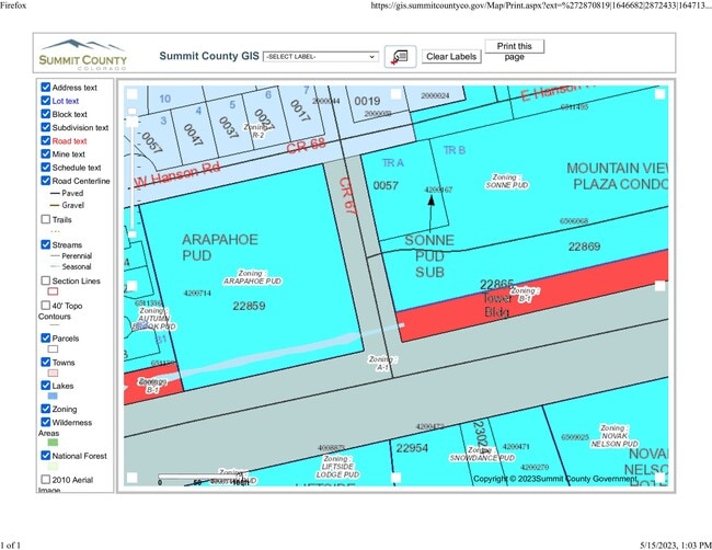
TRACT A SONNE PUD
4200167
Summit
Commercialacreage
Colorado
CPUD
a
B and X Area of moderate flood hazard, usually the area between the limits of the 100-year and 500-year floods.
0.25 AC
2023
Colorado Ski Area
2024
Other Market Areas
000201
NEARBY LISTINGS FOR SALE OR LEASE
-
-
View all Dillon listings for sale on LoopNet.com
DEMOGRAPHICS near 57 Rasor Dr
1 mile
3 mile
5 mile
2024 Total Population
943
3,402
7,198
2029 Population
1,006
3,540
7,380
Pop Growth 2024-2029
+ 6.68%
+ 4.06%
+ 2.53%
Average Age
42
41
39
2024 Total Households
429
1,464
2,902
HH Growth 2024-2029
+ 6.99%
+ 4.37%
+ 2.72%
Median Household Inc
$90,908
$119,122
$119,202
Avg Household Size
1.90
2.10
2.30
2024 Avg HH Vehicles
2.00
2.00
2.00
Median Home Value
$946,428
$891,931
$922,056
Median Year Built
1999
1998
1997
Nearby Places
Map Layers
Map Styles
 Street
 Aerial
Transit
 Traffic
 Biking
Places
Listings with unknown addresses are not visible on the map
- Restaurants
- Banks
- Shops
- Fitness
- Groceries
Nearby Properties
Address
Land Use
TOTAL SIZE
Lot Size
Zoning
Address
Land Use
TOTAL SIZE
Lot Size
Zoning
104,317 SF
20.70 AC
CPUD
Address
Land Use
TOTAL SIZE
Lot Size
Zoning
146,160 SF
4.29 AC
CPUD
Address
Land Use
TOTAL SIZE
Lot Size
Zoning
8,700 SF
73.10 AC
PUD
Address
Land Use
TOTAL SIZE
Lot Size
Zoning
8.94 AC
CPUD
Address
Land Use
TOTAL SIZE
Lot Size
Zoning
80,728 SF
2.80 AC
CPUD
Address
Land Use
TOTAL SIZE
Lot Size
Zoning
7.71 AC
CPUD
Address
Land Use
TOTAL SIZE
Lot Size
Zoning
36,401 SF
CPUD
Address
Land Use
TOTAL SIZE
Lot Size
Zoning
26,071 SF
1.47 AC
CPUD
Address
Land Use
TOTAL SIZE
Lot Size
Zoning
5.95 AC
PUD
Address
Land Use
TOTAL SIZE
Lot Size
Zoning
6,241 SF
8.73 AC
CPUD
Address
Land Use
TOTAL SIZE
Lot Size
Zoning
384 SF
10.84 AC
R-4
Address
Land Use
TOTAL SIZE
Lot Size
Zoning
9,652 SF
1.92 AC
CPUD
Address
Land Use
TOTAL SIZE
Lot Size
Zoning
4,486 SF
1.09 AC
CPUD
Address
Land Use
TOTAL SIZE
Lot Size
Zoning
868 SF
228.24 AC
PUD
Address
Land Use
TOTAL SIZE
Lot Size
Zoning
10,655 SF
1.92 AC
CPUD
Address
Land Use
TOTAL SIZE
Lot Size
Zoning
4,983 SF
1.09 AC
CPUD
Address
Land Use
TOTAL SIZE
Lot Size
Zoning
7,628 SF
0.16 AC
CPUD
Address
Land Use
TOTAL SIZE
Lot Size
Zoning
6,893 SF
1.09 AC
CPUD
Address
Land Use
TOTAL SIZE
Lot Size
Zoning
3,408 SF
5.74 AC
CPUD
Address
Land Use
TOTAL SIZE
Lot Size
Zoning
10,818 SF
0.46 AC
CPUD
Address
Land Use
TOTAL SIZE
Lot Size
Zoning
4,558 SF
0.84 AC
CPUD
Address
Land Use
TOTAL SIZE
Lot Size
Zoning
6,184 SF
1.92 AC
CPUD
Address
Land Use
TOTAL SIZE
Lot Size
Zoning
7,006 SF
1.09 AC
CB-1
Address
Land Use
TOTAL SIZE
Lot Size
Zoning
12,192 SF
CPUD
Address
Land Use
TOTAL SIZE
Lot Size
Zoning
2.69 AC
CPUD
Address
Land Use
TOTAL SIZE
Lot Size
Zoning
7,009 SF
0.78 AC
CPUD
Address
Land Use
TOTAL SIZE
Lot Size
Zoning
7,752 SF
1.61 AC
CPUD
Address
Land Use
TOTAL SIZE
Lot Size
Zoning
8,562 SF
1.32 AC
CPUD
Address
Land Use
TOTAL SIZE
Lot Size
Zoning
7,831 SF
1.61 AC
CPUD
Address
Land Use
TOTAL SIZE
Lot Size
Zoning
0.62 AC
CPUD
The World's #1 Commercial Real Estate Marketplace
Connect with us
© 2026 CoStar Group
The information above has been obtained from sources believed reliable. While we do not doubt its accuracy we have not verified it and make no guarantee, warranty or representation about it. It is your responsibility to independently confirm its accuracy and completeness. Any projections, opinions, assumptions, or estimates used are for example only and do not represent the current or future performance of the property. The value of this transaction to you depends on tax and other factors which should be evaluated by your tax, financial, and legal advisors. You and your advisors should conduct a careful, independent investigation of the property to determine to your satisfaction the suitability of the property for your needs.