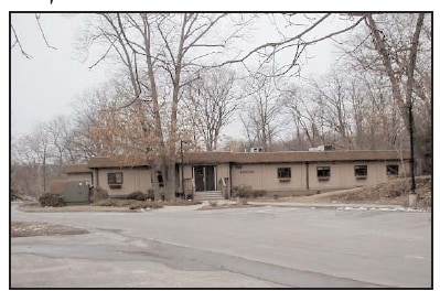
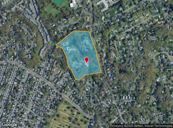
Property Record
57 W Rocks Rd, Norwalk, CT 06851

NEARBY LISTINGS FOR SALE OR LEASE
-
-
View all Norwalk listings for sale on LoopNet.com
Property Detail
57 W Rocks Rd
NORW-000005-000021-000175
Fairfield
Publicschool
Connecticut
X
175
09001C0393G
13.18 AC
2025
Norwalk
2025
Westchester/So Connecticut
042800
Bridgeport-Stamford-Norwalk, CT
DEMOGRAPHICS near 57 W Rocks Rd
1 Mile
3 Mile
5 Mile
2024 Total Population
16,570
89,481
145,427
2029 Population
16,490
89,349
145,689
Pop Growth 2024-2029
(0.48%)
(0.15%)
+ 0.18%
Average Age
41
40
40
2024 Total Households
6,629
35,188
54,676
HH Growth 2024-2029
(0.53%)
(0.11%)
+ 0.15%
Median Household Inc
$87,592
$96,466
$120,509
Avg Household Size
2.40
2.50
2.60
2024 Avg HH Vehicles
2.00
2.00
2.00
Median Home Value
$430,837
$491,029
$721,537
Median Year Built
1965
1966
1965
Nearby Places
Map Layers
Map Styles
 Street
 Aerial
- Restaurants
- Banks
- Shops
- Fitness
- Groceries
PUBLIC TRANSPORTATION
COMMUTER RAIL
East Norwalk Station (New Haven Line - Metro-North Commuter Railroad Company (Metro-North))
DRIVE
WALK
Distance
East Norwalk Station (New Haven Line - Metro-North Commuter Railroad Company (Metro-North))
3 min
2.1 mi
Merritt 7 Station (New Haven Line - Metro-North Commuter Railroad Company (Metro-North))
DRIVE
WALK
Distance
Merritt 7 Station (New Haven Line - Metro-North Commuter Railroad Company (Metro-North))
5 min
2.1 mi
AIRPORT
Westchester County
DRIVE
WALK
Distance
Westchester County
34 min
23.2 mi
Tweed/New Haven
DRIVE
WALK
Distance
Tweed/New Haven
56 min
37.4 mi
Freight Ports
Port of New Haven
DRIVE
WALK
Distance
Port of New Haven
51 min
34.6 mi
Nearby Properties
Address
Land Use
TOTAL SIZE
Lot Size
Zoning
Address
Land Use
TOTAL SIZE
Lot Size
Zoning
4.49 AC
CBDB
Address
Land Use
TOTAL SIZE
Lot Size
Zoning
749,988 SF
4.52 AC
CBDB
Address
Land Use
TOTAL SIZE
Lot Size
Zoning
339,272 SF
4.07 AC
EO
Address
Land Use
TOTAL SIZE
Lot Size
Zoning
6.80 AC
B2
Address
Land Use
TOTAL SIZE
Lot Size
Zoning
226,920 SF
24.75 AC
B
Address
Land Use
TOTAL SIZE
Lot Size
Zoning
28.64 AC
DE-10
Address
Land Use
TOTAL SIZE
Lot Size
Zoning
4.44 AC
CBDB
Address
Land Use
TOTAL SIZE
Lot Size
Zoning
248,486 SF
6.57 AC
EO
Address
Land Use
TOTAL SIZE
Lot Size
Zoning
292,852 SF
3.38 AC
EO
Address
Land Use
TOTAL SIZE
Lot Size
Zoning
254,126 SF
3.33 AC
EO
Address
Land Use
TOTAL SIZE
Lot Size
Zoning
269,100 SF
38.37 AC
RI
Address
Land Use
TOTAL SIZE
Lot Size
Zoning
320,588 SF
3.22 AC
EO
Address
Land Use
TOTAL SIZE
Lot Size
Zoning
254,126 SF
3.06 AC
EO
Address
Land Use
TOTAL SIZE
Lot Size
Zoning
252,316 SF
Address
Land Use
TOTAL SIZE
Lot Size
Zoning
271,344 SF
2.36 AC
EO
Address
Land Use
TOTAL SIZE
Lot Size
Zoning
1.44 AC
BCD/H
Address
Land Use
TOTAL SIZE
Lot Size
Zoning
124,373 SF
13.87 AC
A2
Address
Land Use
TOTAL SIZE
Lot Size
Zoning
101,688 SF
5 AC
RI
Address
Land Use
TOTAL SIZE
Lot Size
Zoning
17 AC
A2
Address
Land Use
TOTAL SIZE
Lot Size
Zoning
21.34 AC
B2
Address
Land Use
TOTAL SIZE
Lot Size
Zoning
Address
Land Use
TOTAL SIZE
Lot Size
Zoning
128,459 SF
1.49 AC
I1
Address
Land Use
TOTAL SIZE
Lot Size
Zoning
13.46 AC
RB
Address
Land Use
TOTAL SIZE
Lot Size
Zoning
13.10 AC
RBD
Address
Land Use
TOTAL SIZE
Lot Size
Zoning
108,119 SF
3.62 AC
I1
Address
Land Use
TOTAL SIZE
Lot Size
Zoning
41.63 AC
A2
Address
Land Use
TOTAL SIZE
Lot Size
Zoning
200,704 SF
Address
Land Use
TOTAL SIZE
Lot Size
Zoning
175,791 SF
1.58 AC
CBDB
Address
Land Use
TOTAL SIZE
Lot Size
Zoning
23.15 AC
A
Address
Land Use
TOTAL SIZE
Lot Size
Zoning
12.30 AC
AA
The World's #1 Commercial Real Estate Marketplace
Connect with us
© 2025 CoStar Group
The information above has been obtained from sources believed reliable. While we do not doubt its accuracy we have not verified it and make no guarantee, warranty or representation about it. It is your responsibility to independently confirm its accuracy and completeness. Any projections, opinions, assumptions, or estimates used are for example only and do not represent the current or future performance of the property. The value of this transaction to you depends on tax and other factors which should be evaluated by your tax, financial, and legal advisors. You and your advisors should conduct a careful, independent investigation of the property to determine to your satisfaction the suitability of the property for your needs.