Property Record
601 Solana Way, Mount Pleasant, SC 29464


Property Detail
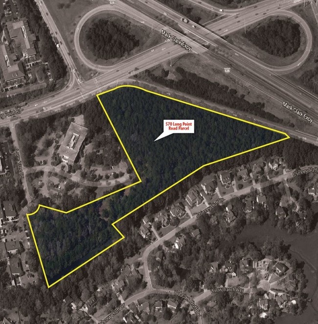
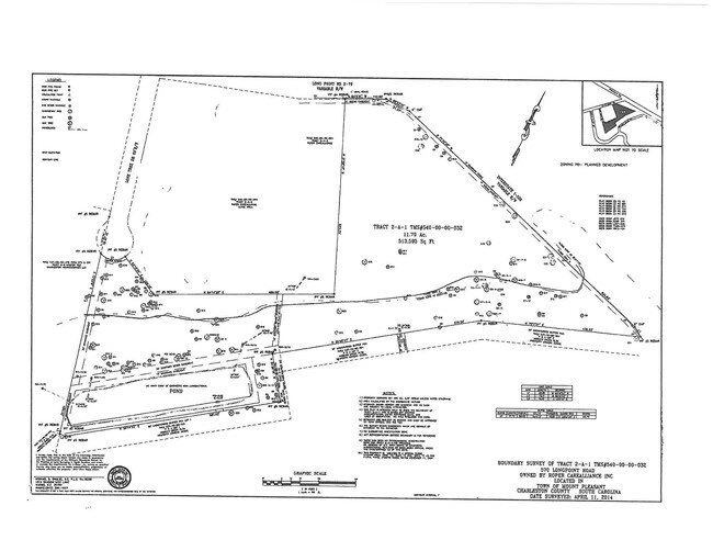
601 Solana Way
540-00-00-032
DESCRIPTION -TRACT 2-A-1
Residencehalldormitories
Charleston
AE The base floodplain where base flood elevations are provided. AE Zones are now used on new format FIRMs instead of A1-A30 Zones.
South Carolina
2025
11.80 AC
2024
East Islands/Mt Pleasant
004613
Charleston/N Charleston
1,898 SF
Charleston-North Charleston, SC
NEARBY LISTINGS FOR SALE OR LEASE
-
-
View all Mount Pleasant listings for sale on LoopNet.com
DEMOGRAPHICS near 601 Solana Way
1 mile
3 mile
5 mile
2025 Total Population
6,462
45,961
86,343
2030 Population
6,632
47,713
90,825
Pop Growth 2025-2030
+ 2.63%
+ 3.81%
+ 5.19%
Average Age
41
42
42
2025 Total Households
2,483
19,781
36,607
HH Growth 2025-2030
+ 2.58%
+ 3.95%
+ 5.44%
Median Household Inc
$133,695
$113,256
$117,724
Avg Household Size
2.50
2.20
2.30
2025 Avg HH Vehicles
2.00
2.00
2.00
Median Home Value
$743,536
$765,183
$794,958
Median Year Built
1994
1993
1998
Nearby Places
Map Layers
Map Styles
 Street
 Aerial
Transit
 Traffic
 Biking
Places
Listings with unknown addresses are not visible on the map
- Restaurants
- Banks
- Shops
- Fitness
- Groceries
PUBLIC TRANSPORTATION
AIRPORT
Charleston AFB/International
Drive
Walk
Distance
Charleston AFB/International
25 min
17.1 mi
Freight Ports
Wando Welch Terminal
Drive
Walk
Distance
Wando Welch Terminal
3 min
1.1 mi
SALE & LEASE HISTORY
LISTING DATE
SALE/LEASE

Sep 24, 2016
For Sale
Nearby Properties
Address
Land Use
TOTAL SIZE
Lot Size
Zoning
Address
Land Use
TOTAL SIZE
Lot Size
Zoning
247,883 SF
16.26 AC
Address
Land Use
TOTAL SIZE
Lot Size
Zoning
372,400 SF
5.59 AC
CHARLESTON
Address
Land Use
TOTAL SIZE
Lot Size
Zoning
Address
Land Use
TOTAL SIZE
Lot Size
Zoning
58,764 SF
25 AC
CHARLESTON
Address
Land Use
TOTAL SIZE
Lot Size
Zoning
29,614 SF
4.08 AC
CHARLESTON
Address
Land Use
TOTAL SIZE
Lot Size
Zoning
21,432 SF
1.27 AC
CHARLESTON
Address
Land Use
TOTAL SIZE
Lot Size
Zoning
9,520 SF
2.04 AC
CHARLESTON
Address
Land Use
TOTAL SIZE
Lot Size
Zoning
6.33 AC
CHARLESTON
Address
Land Use
TOTAL SIZE
Lot Size
Zoning
30,014 SF
2.24 AC
CHARLESTON
Address
Land Use
TOTAL SIZE
Lot Size
Zoning
4,128 SF
0.41 AC
CHARLESTON
Address
Land Use
TOTAL SIZE
Lot Size
Zoning
18,316 SF
14.16 AC
Address
Land Use
TOTAL SIZE
Lot Size
Zoning
15,957 SF
3.80 AC
Address
Land Use
TOTAL SIZE
Lot Size
Zoning
3,462 SF
24.85 AC
Address
Land Use
TOTAL SIZE
Lot Size
Zoning
CHARLESTON
Address
Land Use
TOTAL SIZE
Lot Size
Zoning
CHARLESTON
Address
Land Use
TOTAL SIZE
Lot Size
Zoning
6,572 SF
23.28 AC
Address
Land Use
TOTAL SIZE
Lot Size
Zoning
0.65 AC
CHARLESTON
Address
Land Use
TOTAL SIZE
Lot Size
Zoning
Address
Land Use
TOTAL SIZE
Lot Size
Zoning
4,380 SF
CHARLESTON
Address
Land Use
TOTAL SIZE
Lot Size
Zoning
3.53 AC
CHARLESTON
Address
Land Use
TOTAL SIZE
Lot Size
Zoning
1,222 SF
13.62 AC
Address
Land Use
TOTAL SIZE
Lot Size
Zoning
37,472 SF
9.04 AC
Address
Land Use
TOTAL SIZE
Lot Size
Zoning
12,000 SF
0.73 AC
CHARLESTON
Address
Land Use
TOTAL SIZE
Lot Size
Zoning
15,720 SF
3.10 AC
CHARLESTON
Address
Land Use
TOTAL SIZE
Lot Size
Zoning
3,408 SF
CHARLESTON
Address
Land Use
TOTAL SIZE
Lot Size
Zoning
19,994 SF
2.04 AC
Address
Land Use
TOTAL SIZE
Lot Size
Zoning
3,402 SF
CHARLESTON
Address
Land Use
TOTAL SIZE
Lot Size
Zoning
17,412 SF
1.25 AC
CHARLESTON
Address
Land Use
TOTAL SIZE
Lot Size
Zoning
11,252 SF
0.62 AC
CHARLESTON
Address
Land Use
TOTAL SIZE
Lot Size
Zoning
3,408 SF
CHARLESTON
The World's #1 Commercial Real Estate Marketplace
Connect with us
© 2026 CoStar Group
The information above has been obtained from sources believed reliable. While we do not doubt its accuracy we have not verified it and make no guarantee, warranty or representation about it. It is your responsibility to independently confirm its accuracy and completeness. Any projections, opinions, assumptions, or estimates used are for example only and do not represent the current or future performance of the property. The value of this transaction to you depends on tax and other factors which should be evaluated by your tax, financial, and legal advisors. You and your advisors should conduct a careful, independent investigation of the property to determine to your satisfaction the suitability of the property for your needs.