Property Record
5700 Lenore St, Fort Worth, TX 76134
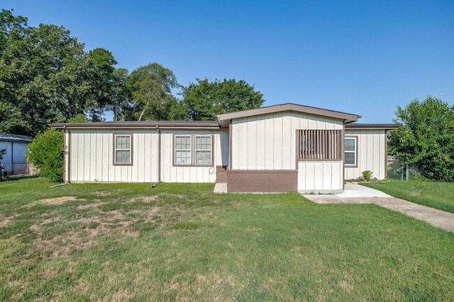


This Property Is For Sale
NEARBY LISTINGS FOR SALE OR LEASE
Property Detail
5700 Lenore St
Dallas-Fort Worth-Arlington, TX
Greenbriar Addition-Ft Worth
01104136
Tarrant
Sfr
Texas
X
0.23 AC
48439C0315L
West Southwest Ft Worth
1,422 SF
Dallas/Ft Worth
DEMOGRAPHICS near 5700 Lenore St
1 Mile
3 Mile
5 Mile
2024 Total Population
9,410
119,210
305,439
2029 Population
9,876
124,927
322,236
Pop Growth 2024-2029
+ 4.95%
+ 4.80%
+ 5.50%
Average Age
37
36
36
2024 Total Households
2,951
38,460
104,076
HH Growth 2024-2029
+ 5.15%
+ 4.90%
+ 5.70%
Median Household Inc
$62,892
$63,660
$68,081
Avg Household Size
3.10
3.00
2.80
2024 Avg HH Vehicles
2.00
2.00
2.00
Median Home Value
$219,089
$226,582
$261,323
Median Year Built
1970
1973
1980
Nearby Places
Map Layers
Map Styles
 Street
 Aerial
- Restaurants
- Banks
- Shops
- Fitness
- Groceries
PUBLIC TRANSPORTATION
COMMUTER RAIL
Texas And Pacific (T&P) (Trinity Railway Express - Dallas Area Rapid Transit (DART))
DRIVE
WALK
Distance
Texas And Pacific (T&P) (Trinity Railway Express - Dallas Area Rapid Transit (DART))
10 min
7.0 mi
DRIVE
WALK
Distance
11 min
7.2 mi
AIRPORT
Dallas-Fort Worth International
DRIVE
WALK
Distance
Dallas-Fort Worth International
41 min
31.3 mi
Dallas Love Field
DRIVE
WALK
Distance
Dallas Love Field
52 min
40.0 mi
Nearby Properties
Address
Land Use
TOTAL SIZE
Lot Size
Zoning
Address
Land Use
TOTAL SIZE
Lot Size
Zoning
661,238 SF
38.80 AC
Address
Land Use
TOTAL SIZE
Lot Size
Zoning
1,623,188 SF
84.13 AC
Address
Land Use
TOTAL SIZE
Lot Size
Zoning
555,914 SF
31.06 AC
Address
Land Use
TOTAL SIZE
Lot Size
Zoning
948,833 SF
64.37 AC
Address
Land Use
TOTAL SIZE
Lot Size
Zoning
343,416 SF
101.49 AC
Address
Land Use
TOTAL SIZE
Lot Size
Zoning
1,129,204 SF
74.34 AC
Address
Land Use
TOTAL SIZE
Lot Size
Zoning
1,402,986 SF
68.89 AC
Address
Land Use
TOTAL SIZE
Lot Size
Zoning
781,200 SF
37.80 AC
Address
Land Use
TOTAL SIZE
Lot Size
Zoning
1,126,017 SF
76.27 AC
Address
Land Use
TOTAL SIZE
Lot Size
Zoning
660,000 SF
33.91 AC
Address
Land Use
TOTAL SIZE
Lot Size
Zoning
647,228 SF
31.47 AC
Address
Land Use
TOTAL SIZE
Lot Size
Zoning
593,917 SF
45.85 AC
Address
Land Use
TOTAL SIZE
Lot Size
Zoning
319,017 SF
14.68 AC
Address
Land Use
TOTAL SIZE
Lot Size
Zoning
193,098 SF
25 AC
Address
Land Use
TOTAL SIZE
Lot Size
Zoning
462,777 SF
37.49 AC
Address
Land Use
TOTAL SIZE
Lot Size
Zoning
266,514 SF
14.06 AC
Address
Land Use
TOTAL SIZE
Lot Size
Zoning
615,054 SF
27.49 AC
Address
Land Use
TOTAL SIZE
Lot Size
Zoning
489,679 SF
27.08 AC
Address
Land Use
TOTAL SIZE
Lot Size
Zoning
488,564 SF
29.43 AC
Address
Land Use
TOTAL SIZE
Lot Size
Zoning
455,000 SF
6 AC
Address
Land Use
TOTAL SIZE
Lot Size
Zoning
562,944 SF
35.69 AC
Address
Land Use
TOTAL SIZE
Lot Size
Zoning
147,466 SF
19.19 AC
Address
Land Use
TOTAL SIZE
Lot Size
Zoning
619,649 SF
53.64 AC
Address
Land Use
TOTAL SIZE
Lot Size
Zoning
585,000 SF
28.75 AC
Address
Land Use
TOTAL SIZE
Lot Size
Zoning
224,000 SF
24.35 AC
Address
Land Use
TOTAL SIZE
Lot Size
Zoning
244,871 SF
11.88 AC
Address
Land Use
TOTAL SIZE
Lot Size
Zoning
456,500 SF
29.55 AC
Address
Land Use
TOTAL SIZE
Lot Size
Zoning
487,507 SF
145.80 AC
Address
Land Use
TOTAL SIZE
Lot Size
Zoning
865,460 SF
41.14 AC
Address
Land Use
TOTAL SIZE
Lot Size
Zoning
391,540 SF
21.17 AC
The World's #1 Commercial Real Estate Marketplace
Connect with us
© 2026 CoStar Group
The information above has been obtained from sources believed reliable. While we do not doubt its accuracy we have not verified it and make no guarantee, warranty or representation about it. It is your responsibility to independently confirm its accuracy and completeness. Any projections, opinions, assumptions, or estimates used are for example only and do not represent the current or future performance of the property. The value of this transaction to you depends on tax and other factors which should be evaluated by your tax, financial, and legal advisors. You and your advisors should conduct a careful, independent investigation of the property to determine to your satisfaction the suitability of the property for your needs.