Property Record
5700 N Expressway, Brownsville, TX 78526
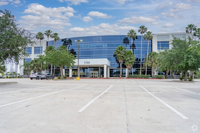

This Property Is For Sale
Current Lease Availabilities
NEARBY LISTINGS FOR SALE OR LEASE
-
-
View all Brownsville listings for lease on LoopNet.com
Property Detail
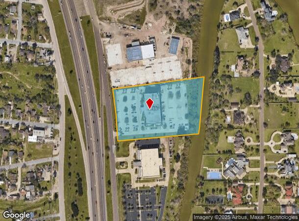
5700 N Expressway
Brownsville-Harlingen, TX
R A Lieck Subdivision
764150-0010-020300
LIECK SUBDIVISION BLK 1 & 2 5.001 AC OF 19.5 ACS TRACT III
Commercialnec
Cameron
A
Texas
48061C0560F
203
2024
5 AC
2025
Greater Brownsville
014402
Brownsville/Harlingen
72,000 SF
DEMOGRAPHICS near 5700 N Expressway
1 Mile
3 Mile
5 Mile
2024 Total Population
2,933
57,255
120,728
2029 Population
3,016
58,490
123,701
Pop Growth 2024-2029
+ 2.83%
+ 2.16%
+ 2.46%
Average Age
34
34
36
2024 Total Households
865
16,761
37,569
HH Growth 2024-2029
+ 2.77%
+ 2.17%
+ 2.51%
Median Household Inc
$109,207
$67,849
$60,011
Avg Household Size
3.40
3.30
3.10
2024 Avg HH Vehicles
2.00
2.00
2.00
Median Home Value
$200,958
$153,068
$140,187
Median Year Built
2004
2001
1997
Nearby Places
Map Layers
Map Styles
 Street
 Aerial
- Restaurants
- Banks
- Shops
- Fitness
- Groceries
PUBLIC TRANSPORTATION
AIRPORT
Brownsville/South Padre Island International
DRIVE
WALK
Distance
Brownsville/South Padre Island International
16 min
9.6 mi
Valley International
DRIVE
WALK
Distance
Valley International
28 min
21.5 mi
Freight Ports
Port of Brownsville
DRIVE
WALK
Distance
Port of Brownsville
14 min
9.0 mi
Nearby Properties
Address
Land Use
TOTAL SIZE
Lot Size
Zoning
Address
Land Use
TOTAL SIZE
Lot Size
Zoning
1,019,535 SF
83.42 AC
I
Address
Land Use
TOTAL SIZE
Lot Size
Zoning
452,559 SF
13.79 AC
C
Address
Land Use
TOTAL SIZE
Lot Size
Zoning
232,467 SF
25.82 AC
C
Address
Land Use
TOTAL SIZE
Lot Size
Zoning
112,834 SF
16.70 AC
C
Address
Land Use
TOTAL SIZE
Lot Size
Zoning
135,686 SF
19.05 AC
C
Address
Land Use
TOTAL SIZE
Lot Size
Zoning
196,847 SF
19.63 AC
Address
Land Use
TOTAL SIZE
Lot Size
Zoning
145,218 SF
23.16 AC
Address
Land Use
TOTAL SIZE
Lot Size
Zoning
100,491 SF
14 AC
C
Address
Land Use
TOTAL SIZE
Lot Size
Zoning
66,340 SF
3.85 AC
C
Address
Land Use
TOTAL SIZE
Lot Size
Zoning
56,804 SF
1.83 AC
Address
Land Use
TOTAL SIZE
Lot Size
Zoning
73,090 SF
3.08 AC
C
Address
Land Use
TOTAL SIZE
Lot Size
Zoning
60,747 SF
2.59 AC
C
Address
Land Use
TOTAL SIZE
Lot Size
Zoning
62,344 SF
2.92 AC
Address
Land Use
TOTAL SIZE
Lot Size
Zoning
204,001 SF
20.13 AC
C
Address
Land Use
TOTAL SIZE
Lot Size
Zoning
52,668 SF
2.23 AC
Address
Land Use
TOTAL SIZE
Lot Size
Zoning
102,042 SF
8.68 AC
C
Address
Land Use
TOTAL SIZE
Lot Size
Zoning
78,583 SF
5.01 AC
C
Address
Land Use
TOTAL SIZE
Lot Size
Zoning
106,836 SF
21.76 AC
Address
Land Use
TOTAL SIZE
Lot Size
Zoning
72,320 SF
27.36 AC
Address
Land Use
TOTAL SIZE
Lot Size
Zoning
65,732 SF
21.30 AC
Address
Land Use
TOTAL SIZE
Lot Size
Zoning
174,826 SF
5.82 AC
Address
Land Use
TOTAL SIZE
Lot Size
Zoning
46,381 SF
2.16 AC
Address
Land Use
TOTAL SIZE
Lot Size
Zoning
48,862 SF
1.22 AC
C
Address
Land Use
TOTAL SIZE
Lot Size
Zoning
97,077 SF
16.78 AC
Address
Land Use
TOTAL SIZE
Lot Size
Zoning
82,556 SF
36.56 AC
Address
Land Use
TOTAL SIZE
Lot Size
Zoning
48,468 SF
2.65 AC
C
Address
Land Use
TOTAL SIZE
Lot Size
Zoning
55,880 SF
5 AC
Address
Land Use
TOTAL SIZE
Lot Size
Zoning
117,600 SF
2.16 AC
Address
Land Use
TOTAL SIZE
Lot Size
Zoning
104,978 SF
20 AC
Address
Land Use
TOTAL SIZE
Lot Size
Zoning
46,656 SF
1.59 AC
C
The World's #1 Commercial Real Estate Marketplace
Connect with us
© 2026 CoStar Group
The information above has been obtained from sources believed reliable. While we do not doubt its accuracy we have not verified it and make no guarantee, warranty or representation about it. It is your responsibility to independently confirm its accuracy and completeness. Any projections, opinions, assumptions, or estimates used are for example only and do not represent the current or future performance of the property. The value of this transaction to you depends on tax and other factors which should be evaluated by your tax, financial, and legal advisors. You and your advisors should conduct a careful, independent investigation of the property to determine to your satisfaction the suitability of the property for your needs.