Property Record
5700 N Hammonds Ferry Rd, Linthicum Heights, MD 21090
NEARBY LISTINGS FOR SALE OR LEASE
-
-
View all Linthicum Heights listings for sale on LoopNet.com
Property Detail
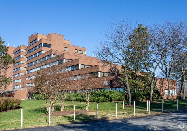
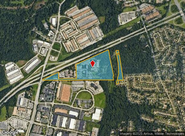
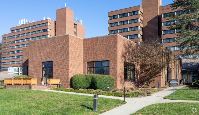
5700 N Hammonds Ferry Rd
Baltimore-Columbia-Towson, MD
M M & P Maritime
05-000-90050911
41.142 ACRES M M & P MARITIME
Commercialacreage
Anne Arundel
X
Maryland
2400100510H
41.14 AC
2024
BWI Airport
2025
Baltimore
751200
DEMOGRAPHICS near 5700 N Hammonds Ferry Rd
1 Mile
3 Mile
5 Mile
2024 Total Population
5,399
63,743
198,552
2029 Population
5,603
64,099
198,348
Pop Growth 2024-2029
+ 3.78%
+ 0.56%
(0.10%)
Average Age
41
39
38
2024 Total Households
2,283
23,361
73,161
HH Growth 2024-2029
+ 4.34%
+ 0.62%
(0.24%)
Median Household Inc
$106,075
$85,812
$71,540
Avg Household Size
2.40
2.60
2.60
2024 Avg HH Vehicles
2.00
2.00
2.00
Median Home Value
$378,880
$299,749
$278,940
Median Year Built
1966
1961
1960
Nearby Places
Map Layers
Map Styles
 Street
 Aerial
- Restaurants
- Banks
- Shops
- Fitness
- Groceries
PUBLIC TRANSPORTATION
COMMUTER RAIL
St Denis Marc Nb (CAMDEN - WASHINGTON - Maryland Transit Administration)
DRIVE
WALK
Distance
St Denis Marc Nb (CAMDEN - WASHINGTON - Maryland Transit Administration)
9 min
4.3 mi
St Denis (Camden Line - Maryland Area Regional Commuter Trains (The MARC))
DRIVE
WALK
Distance
St Denis (Camden Line - Maryland Area Regional Commuter Trains (The MARC))
9 min
4.3 mi
AIRPORT
Baltimore/Washington International Thurgood Marshall
DRIVE
WALK
Distance
Baltimore/Washington International Thurgood Marshall
9 min
3.5 mi
Freight Ports
Port of Baltimore
DRIVE
WALK
Distance
Port of Baltimore
15 min
8.0 mi
Nearby Properties
Address
Land Use
TOTAL SIZE
Lot Size
Zoning
Address
Land Use
TOTAL SIZE
Lot Size
Zoning
430,940 SF
18.81 AC
MXDT
Address
Land Use
TOTAL SIZE
Lot Size
Zoning
305,483 SF
11.38 AC
MXDT
Address
Land Use
TOTAL SIZE
Lot Size
Zoning
332,190 SF
21.80 AC
W1-BW
Address
Land Use
TOTAL SIZE
Lot Size
Zoning
454,684 SF
6.88 AC
W1B
Address
Land Use
TOTAL SIZE
Lot Size
Zoning
383,697 SF
68.35 AC
R5
Address
Land Use
TOTAL SIZE
Lot Size
Zoning
60,200 SF
778.66 AC
R1
Address
Land Use
TOTAL SIZE
Lot Size
Zoning
778.66 AC
R1
Address
Land Use
TOTAL SIZE
Lot Size
Zoning
292,269 SF
15.86 AC
W1-BW
Address
Land Use
TOTAL SIZE
Lot Size
Zoning
231,128 SF
8.30 AC
W1-BW
Address
Land Use
TOTAL SIZE
Lot Size
Zoning
19.20 AC
R15
Address
Land Use
TOTAL SIZE
Lot Size
Zoning
1,489,438 SF
74.22 AC
W2
Address
Land Use
TOTAL SIZE
Lot Size
Zoning
1,555.10 AC
R1
Address
Land Use
TOTAL SIZE
Lot Size
Zoning
263,024 SF
6.87 AC
C3
Address
Land Use
TOTAL SIZE
Lot Size
Zoning
18.86 AC
DR16
Address
Land Use
TOTAL SIZE
Lot Size
Zoning
184,317 SF
16.23 AC
MH
Address
Land Use
TOTAL SIZE
Lot Size
Zoning
185,652 SF
18.76 AC
W1
Address
Land Use
TOTAL SIZE
Lot Size
Zoning
16.26 AC
R15
Address
Land Use
TOTAL SIZE
Lot Size
Zoning
15.05 AC
R15
Address
Land Use
TOTAL SIZE
Lot Size
Zoning
187,814 SF
38.47 AC
R5
Address
Land Use
TOTAL SIZE
Lot Size
Zoning
48,300 SF
30.96 AC
ML
Address
Land Use
TOTAL SIZE
Lot Size
Zoning
109,605 SF
21.01 AC
W1
Address
Land Use
TOTAL SIZE
Lot Size
Zoning
116,600 SF
8.97 AC
C4
Address
Land Use
TOTAL SIZE
Lot Size
Zoning
101,220 SF
17.51 AC
DR5.5
Address
Land Use
TOTAL SIZE
Lot Size
Zoning
338,255 SF
42.87 AC
W1-BW
Address
Land Use
TOTAL SIZE
Lot Size
Zoning
204,000 SF
7.70 AC
W1-BW
Address
Land Use
TOTAL SIZE
Lot Size
Zoning
194,652 SF
20.49 AC
W1-BW
Address
Land Use
TOTAL SIZE
Lot Size
Zoning
19.86 AC
DR16
Address
Land Use
TOTAL SIZE
Lot Size
Zoning
145,226 SF
9.24 AC
W1
Address
Land Use
TOTAL SIZE
Lot Size
Zoning
21.46 AC
ML
The World's #1 Commercial Real Estate Marketplace
Connect with us
© 2026 CoStar Group
The information above has been obtained from sources believed reliable. While we do not doubt its accuracy we have not verified it and make no guarantee, warranty or representation about it. It is your responsibility to independently confirm its accuracy and completeness. Any projections, opinions, assumptions, or estimates used are for example only and do not represent the current or future performance of the property. The value of this transaction to you depends on tax and other factors which should be evaluated by your tax, financial, and legal advisors. You and your advisors should conduct a careful, independent investigation of the property to determine to your satisfaction the suitability of the property for your needs.