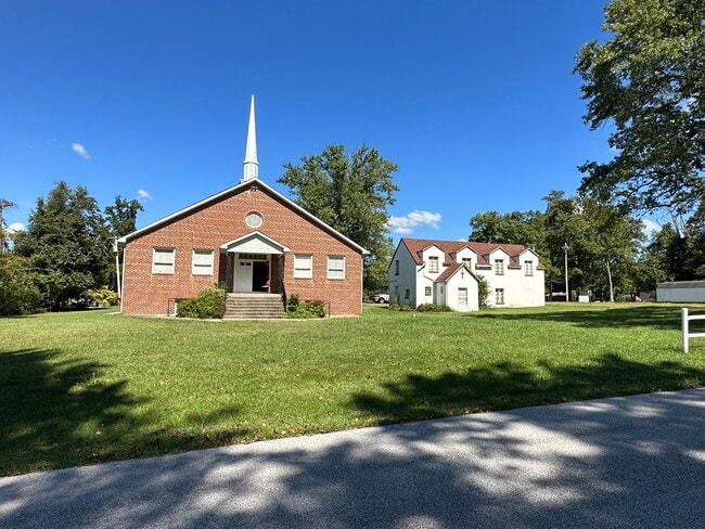
Property Record
5700 Ranelagh Rd, White Marsh, MD 21162
NEARBY LISTINGS FOR SALE OR LEASE
-
-
View all White Marsh listings for sale on LoopNet.com
Property Detail
5700 Ranelagh Rd
Baltimore-Columbia-Towson, MD
Darryl Gardens
11-1107059577
LT 1, 13 DARRYL GARDENS
Taxexempt
Baltimore
X
Maryland
2400100295H
1
2024
0.92 AC
2025
Baltimore County East
411302
Baltimore
DEMOGRAPHICS near 5700 Ranelagh Rd
1 Mile
3 Mile
5 Mile
2024 Total Population
3,105
31,177
109,687
2029 Population
3,134
31,239
109,334
Pop Growth 2024-2029
+ 0.93%
+ 0.20%
(0.32%)
Average Age
39
42
41
2024 Total Households
954
11,520
41,664
HH Growth 2024-2029
+ 0.84%
+ 0.20%
(0.39%)
Median Household Inc
$153,892
$111,033
$92,459
Avg Household Size
3.10
2.60
2.60
2024 Avg HH Vehicles
2.00
2.00
2.00
Median Home Value
$460,703
$379,533
$325,003
Median Year Built
2004
1990
1985
Nearby Places
Map Layers
Map Styles
 Street
 Aerial
- Restaurants
- Banks
- Shops
- Fitness
- Groceries
PUBLIC TRANSPORTATION
COMMUTER RAIL
Martin State Airport (PENN - WASHINGTON - Maryland Area Regional Commuter Trains (The MARC), Penn Line - Maryland Area Regional Commuter Trains (The MARC))
DRIVE
WALK
Distance
Martin State Airport (PENN - WASHINGTON - Maryland Area Regional Commuter Trains (The MARC), Penn Line - Maryland Area Regional Commuter Trains (The MARC))
13 min
7.4 mi
Edgewood (PENN - WASHINGTON - Maryland Area Regional Commuter Trains (The MARC), Penn Line - Maryland Area Regional Commuter Trains (The MARC))
DRIVE
WALK
Distance
Edgewood (PENN - WASHINGTON - Maryland Area Regional Commuter Trains (The MARC), Penn Line - Maryland Area Regional Commuter Trains (The MARC))
15 min
8.0 mi
AIRPORT
Baltimore/Washington International Thurgood Marshall
DRIVE
WALK
Distance
Baltimore/Washington International Thurgood Marshall
40 min
26.0 mi
Freight Ports
Port of Baltimore
DRIVE
WALK
Distance
Port of Baltimore
27 min
17.3 mi
SALE & LEASE HISTORY
LISTING DATE
SALE/LEASE

Oct 01, 2023
For Sale
Nearby Properties
Address
Land Use
TOTAL SIZE
Lot Size
Zoning
Address
Land Use
TOTAL SIZE
Lot Size
Zoning
253,842 SF
69.33 AC
R2
Address
Land Use
TOTAL SIZE
Lot Size
Zoning
240,121 SF
9.97 AC
Address
Land Use
TOTAL SIZE
Lot Size
Zoning
225,070 SF
20.65 AC
Address
Land Use
TOTAL SIZE
Lot Size
Zoning
239,798 SF
11.90 AC
Address
Land Use
TOTAL SIZE
Lot Size
Zoning
64,480 SF
20.43 AC
Address
Land Use
TOTAL SIZE
Lot Size
Zoning
100,725 SF
6.30 AC
BL
Address
Land Use
TOTAL SIZE
Lot Size
Zoning
10.88 AC
DR16
Address
Land Use
TOTAL SIZE
Lot Size
Zoning
89,522 SF
4.03 AC
Address
Land Use
TOTAL SIZE
Lot Size
Zoning
141,550 SF
23.81 AC
ML
Address
Land Use
TOTAL SIZE
Lot Size
Zoning
69,744 SF
9.19 AC
BL-CS
Address
Land Use
TOTAL SIZE
Lot Size
Zoning
35,170 SF
5.50 AC
BM
Address
Land Use
TOTAL SIZE
Lot Size
Zoning
49,704 SF
12.60 AC
Address
Land Use
TOTAL SIZE
Lot Size
Zoning
150 AC
R4
Address
Land Use
TOTAL SIZE
Lot Size
Zoning
150 AC
R4
Address
Land Use
TOTAL SIZE
Lot Size
Zoning
60,400 SF
6.42 AC
MHIM
Address
Land Use
TOTAL SIZE
Lot Size
Zoning
28,452 SF
6 AC
R4
Address
Land Use
TOTAL SIZE
Lot Size
Zoning
77,200 SF
13.29 AC
Address
Land Use
TOTAL SIZE
Lot Size
Zoning
5.47 AC
DR16
Address
Land Use
TOTAL SIZE
Lot Size
Zoning
1,340 SF
2.75 AC
Address
Land Use
TOTAL SIZE
Lot Size
Zoning
6.32 AC
DR16
Address
Land Use
TOTAL SIZE
Lot Size
Zoning
86,168 SF
8.89 AC
R4
Address
Land Use
TOTAL SIZE
Lot Size
Zoning
60,724 SF
327.15 AC
Address
Land Use
TOTAL SIZE
Lot Size
Zoning
25,196 SF
4.20 AC
BM
Address
Land Use
TOTAL SIZE
Lot Size
Zoning
104,000 SF
9.61 AC
ML
Address
Land Use
TOTAL SIZE
Lot Size
Zoning
3,399 SF
15.58 AC
B3
Address
Land Use
TOTAL SIZE
Lot Size
Zoning
57,520 SF
73 AC
R4
Address
Land Use
TOTAL SIZE
Lot Size
Zoning
114,969 SF
12.72 AC
Address
Land Use
TOTAL SIZE
Lot Size
Zoning
25,704 SF
6.77 AC
Address
Land Use
TOTAL SIZE
Lot Size
Zoning
52,484 SF
15.21 AC
ML
Address
Land Use
TOTAL SIZE
Lot Size
Zoning
40,035 SF
13.54 AC
The World's #1 Commercial Real Estate Marketplace
Connect with us
© 2026 CoStar Group
The information above has been obtained from sources believed reliable. While we do not doubt its accuracy we have not verified it and make no guarantee, warranty or representation about it. It is your responsibility to independently confirm its accuracy and completeness. Any projections, opinions, assumptions, or estimates used are for example only and do not represent the current or future performance of the property. The value of this transaction to you depends on tax and other factors which should be evaluated by your tax, financial, and legal advisors. You and your advisors should conduct a careful, independent investigation of the property to determine to your satisfaction the suitability of the property for your needs.