Property Record
5700 S Georgia St, Amarillo, TX 79110
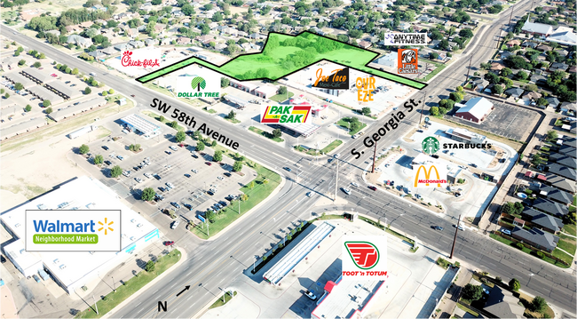

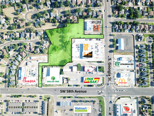
This Property Is For Sale
Property Detail
5700 S Georgia St
Amarillo, TX
THE SHORES # 20, LOT 17B, BLK 0002, 2.1500 ACRES
000000300532
RANDALL
Communitycenter
Texas
2024
17b
2025
2.15 AC
021000
Amarillo
13,975 SF
Other Market Areas
NEARBY LISTINGS FOR SALE OR LEASE
DEMOGRAPHICS near 5700 S Georgia St
1 mile
3 mile
5 mile
2025 Total Population
11,464
77,203
155,141
2030 Population
11,976
80,417
159,717
Pop Growth 2025-2030
+ 4.47%
+ 4.16%
+ 2.95%
Average Age
38
39
39
2025 Total Households
4,763
31,891
63,664
HH Growth 2025-2030
+ 4.79%
+ 4.10%
+ 2.88%
Median Household Inc
$65,548
$73,254
$67,832
Avg Household Size
2.30
2.40
2.40
2025 Avg HH Vehicles
2.00
2.00
2.00
Median Home Value
$162,324
$215,805
$217,058
Median Year Built
1978
1974
1975
Nearby Places
Map Layers
Map Styles
 Street
 Aerial
Transit
 Traffic
 Biking
Places
Listings with unknown addresses are not visible on the map
- Restaurants
- Banks
- Shops
- Fitness
- Groceries
PUBLIC TRANSPORTATION
AIRPORT
Rick Husband Amarillo International
Drive
Walk
Distance
Rick Husband Amarillo International
19 min
12.8 mi
Freight Ports
Tulsa Port Of Catoosa
Drive
Walk
Distance
Tulsa Port Of Catoosa
402 min
380.8 mi
Nearby Properties
Address
Land Use
TOTAL SIZE
Lot Size
Zoning
Address
Land Use
TOTAL SIZE
Lot Size
Zoning
362,796 SF
49.98 AC
A
Address
Land Use
TOTAL SIZE
Lot Size
Zoning
228,223 SF
20.83 AC
Address
Land Use
TOTAL SIZE
Lot Size
Zoning
431,320 SF
14.82 AC
1F2 S
Address
Land Use
TOTAL SIZE
Lot Size
Zoning
342,930 SF
34.57 AC
PD
Address
Land Use
TOTAL SIZE
Lot Size
Zoning
112,261 SF
21.82 AC
Address
Land Use
TOTAL SIZE
Lot Size
Zoning
168,978 SF
4.23 AC
1F2 S
Address
Land Use
TOTAL SIZE
Lot Size
Zoning
168,130 SF
16.32 AC
Address
Land Use
TOTAL SIZE
Lot Size
Zoning
182,242 SF
20.70 AC
Address
Land Use
TOTAL SIZE
Lot Size
Zoning
210,217 SF
10.49 AC
M11
Address
Land Use
TOTAL SIZE
Lot Size
Zoning
74,960 SF
7 AC
R2
Address
Land Use
TOTAL SIZE
Lot Size
Zoning
204,468 SF
17.56 AC
Address
Land Use
TOTAL SIZE
Lot Size
Zoning
80,298 SF
7.75 AC
Address
Land Use
TOTAL SIZE
Lot Size
Zoning
167,257 SF
12.66 AC
Address
Land Use
TOTAL SIZE
Lot Size
Zoning
161,221 SF
11.78 AC
MF1
Address
Land Use
TOTAL SIZE
Lot Size
Zoning
112,005 SF
7.70 AC
GR
Address
Land Use
TOTAL SIZE
Lot Size
Zoning
183,758 SF
16.74 AC
R2
Address
Land Use
TOTAL SIZE
Lot Size
Zoning
132,914 SF
10.20 AC
PD
Address
Land Use
TOTAL SIZE
Lot Size
Zoning
185,895 SF
9.59 AC
Address
Land Use
TOTAL SIZE
Lot Size
Zoning
172,531 SF
10.37 AC
LC
Address
Land Use
TOTAL SIZE
Lot Size
Zoning
297,246 SF
13.91 AC
MF1
Address
Land Use
TOTAL SIZE
Lot Size
Zoning
187,253 SF
9.69 AC
PD
Address
Land Use
TOTAL SIZE
Lot Size
Zoning
120,684 SF
18.94 AC
R2
Address
Land Use
TOTAL SIZE
Lot Size
Zoning
68,214 SF
9.06 AC
Address
Land Use
TOTAL SIZE
Lot Size
Zoning
131,544 SF
16.01 AC
R2
Address
Land Use
TOTAL SIZE
Lot Size
Zoning
155,721 SF
7.38 AC
GR
Address
Land Use
TOTAL SIZE
Lot Size
Zoning
217,018 SF
20.82 AC
LC
Address
Land Use
TOTAL SIZE
Lot Size
Zoning
94,851 SF
5.95 AC
R2
Address
Land Use
TOTAL SIZE
Lot Size
Zoning
92,058 SF
6.89 AC
PD
Address
Land Use
TOTAL SIZE
Lot Size
Zoning
135,251 SF
6.99 AC
MF1
Address
Land Use
TOTAL SIZE
Lot Size
Zoning
694,915 SF
27.22 AC
The World's #1 Commercial Real Estate Marketplace
Connect with us
© 2026 CoStar Group
The information above has been obtained from sources believed reliable. While we do not doubt its accuracy we have not verified it and make no guarantee, warranty or representation about it. It is your responsibility to independently confirm its accuracy and completeness. Any projections, opinions, assumptions, or estimates used are for example only and do not represent the current or future performance of the property. The value of this transaction to you depends on tax and other factors which should be evaluated by your tax, financial, and legal advisors. You and your advisors should conduct a careful, independent investigation of the property to determine to your satisfaction the suitability of the property for your needs.