Property Record
5700 Sky Pointe Dr, Las Vegas, NV 89130
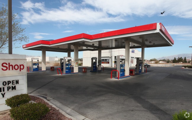


This Property Is For Sale
NEARBY LISTINGS FOR SALE OR LEASE
Property Detail
5700 Sky Pointe Dr
Las Vegas-Henderson-Paradise, NV
Ann Tenaya
125-27-410-007
ANN TENAYA PLAT BOOK 88 PAGE 55 PT LOT 1 BLOCK 1
Storebuilding
Clark
X
Nevada
32003C1745E
1
2025
0.92 AC
2025
Northwest Las Vegas
003303
Las Vegas
4,193 SF
DEMOGRAPHICS near 5700 Sky Pointe Dr
1 Mile
3 Mile
5 Mile
2024 Total Population
13,457
119,932
379,946
2029 Population
14,433
128,526
408,500
Pop Growth 2024-2029
+ 7.25%
+ 7.17%
+ 7.52%
Average Age
41
41
40
2024 Total Households
5,201
44,163
137,142
HH Growth 2024-2029
+ 7.27%
+ 7.20%
+ 7.49%
Median Household Inc
$70,449
$84,142
$79,500
Avg Household Size
2.60
2.70
2.70
2024 Avg HH Vehicles
2.00
2.00
2.00
Median Home Value
$374,105
$396,519
$380,066
Median Year Built
1995
1997
1999
Nearby Places
Map Layers
Map Styles
 Street
 Aerial
- Restaurants
- Banks
- Shops
- Fitness
- Groceries
PUBLIC TRANSPORTATION
AIRPORT
Harry Reid International
DRIVE
WALK
Distance
Harry Reid International
29 min
18.4 mi
Boulder City Municipal
DRIVE
WALK
Distance
Boulder City Municipal
49 min
38.4 mi
Nearby Properties
Address
Land Use
TOTAL SIZE
Lot Size
Zoning
Address
Land Use
TOTAL SIZE
Lot Size
Zoning
647,754 SF
38.57 AC
C2
Address
Land Use
TOTAL SIZE
Lot Size
Zoning
358,316 SF
35.74 AC
TC
Address
Land Use
TOTAL SIZE
Lot Size
Zoning
195,916 SF
5.91 AC
L:T-C
Address
Land Use
TOTAL SIZE
Lot Size
Zoning
6,386 SF
15.82 AC
Address
Land Use
TOTAL SIZE
Lot Size
Zoning
140,690 SF
37.50 AC
CV
Address
Land Use
TOTAL SIZE
Lot Size
Zoning
Address
Land Use
TOTAL SIZE
Lot Size
Zoning
19.10 AC
PF
Address
Land Use
TOTAL SIZE
Lot Size
Zoning
263,881 SF
7.49 AC
R-4
Address
Land Use
TOTAL SIZE
Lot Size
Zoning
201,255 SF
20.95 AC
C1
Address
Land Use
TOTAL SIZE
Lot Size
Zoning
20 AC
CV
Address
Land Use
TOTAL SIZE
Lot Size
Zoning
21.12 AC
RE
Address
Land Use
TOTAL SIZE
Lot Size
Zoning
43,952 SF
7.96 AC
Address
Land Use
TOTAL SIZE
Lot Size
Zoning
178,800 SF
16.79 AC
TC
Address
Land Use
TOTAL SIZE
Lot Size
Zoning
172,927 SF
20.78 AC
TC
Address
Land Use
TOTAL SIZE
Lot Size
Zoning
132,309 SF
12.45 AC
L:T-C
Address
Land Use
TOTAL SIZE
Lot Size
Zoning
3,618 SF
10 AC
L:R-3
Address
Land Use
TOTAL SIZE
Lot Size
Zoning
14.18 AC
MPCPSP
Address
Land Use
TOTAL SIZE
Lot Size
Zoning
3,315 SF
13.23 AC
TC
Address
Land Use
TOTAL SIZE
Lot Size
Zoning
7,103 SF
14.27 AC
L:R-3
Address
Land Use
TOTAL SIZE
Lot Size
Zoning
105,205 SF
18.86 AC
TC
Address
Land Use
TOTAL SIZE
Lot Size
Zoning
196,873 SF
5.25 AC
C2
Address
Land Use
TOTAL SIZE
Lot Size
Zoning
4,273 SF
16.04 AC
Address
Land Use
TOTAL SIZE
Lot Size
Zoning
4,273 SF
15.06 AC
Address
Land Use
TOTAL SIZE
Lot Size
Zoning
129,339 SF
13.43 AC
C2
Address
Land Use
TOTAL SIZE
Lot Size
Zoning
18.02 AC
PF
Address
Land Use
TOTAL SIZE
Lot Size
Zoning
18.93 AC
CV
Address
Land Use
TOTAL SIZE
Lot Size
Zoning
267,271 SF
22.36 AC
C1
Address
Land Use
TOTAL SIZE
Lot Size
Zoning
90,599 SF
12.14 AC
Address
Land Use
TOTAL SIZE
Lot Size
Zoning
117,088 SF
5.49 AC
Address
Land Use
TOTAL SIZE
Lot Size
Zoning
2,224 SF
8.66 AC
TC
The World's #1 Commercial Real Estate Marketplace
Connect with us
© 2025 CoStar Group
The information above has been obtained from sources believed reliable. While we do not doubt its accuracy we have not verified it and make no guarantee, warranty or representation about it. It is your responsibility to independently confirm its accuracy and completeness. Any projections, opinions, assumptions, or estimates used are for example only and do not represent the current or future performance of the property. The value of this transaction to you depends on tax and other factors which should be evaluated by your tax, financial, and legal advisors. You and your advisors should conduct a careful, independent investigation of the property to determine to your satisfaction the suitability of the property for your needs.