Property Record
5701 Environment Dr, Fort Pierce, FL 34981


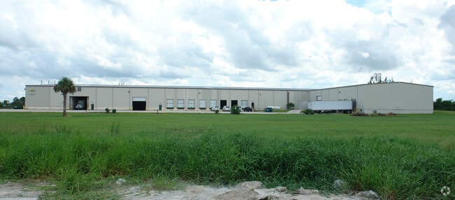

Property Detail
5701 Environment Dr
33-01-500-0002-0002
THE PACKERS OF INDIAN RIVER PLAT ONE LOT 1 (19.47 AC)
Warehouse
ST LUCIE
INDUST HEA
Florida
B and X Area of moderate flood hazard, usually the area between the limits of the 100-year and 500-year floods.
1
2024
19.47 AC
2025
Fort Pierce
381402
Port St Lucie/Fort Pierce
98,067 SF
Port St. Lucie, FL
NEARBY LISTINGS FOR SALE OR LEASE
DEMOGRAPHICS near 5701 Environment Dr
1 mile
3 mile
5 mile
2025 Total Population
3,585
29,911
106,584
2030 Population
4,123
34,507
122,256
Pop Growth 2025-2030
+ 15.01%
+ 15.37%
+ 14.70%
Average Age
39
41
42
2025 Total Households
1,193
10,621
41,459
HH Growth 2025-2030
+ 14.84%
+ 15.16%
+ 14.58%
Median Household Inc
$90,036
$82,584
$65,866
Avg Household Size
2.90
2.70
2.50
2025 Avg HH Vehicles
2.00
2.00
2.00
Median Home Value
$425,000
$421,690
$369,451
Median Year Built
2006
2004
1998
Nearby Places
Map Layers
Map Styles
 Street
 Aerial
Layers
 Traffic
 Biking
Places
Listings with unknown addresses are not visible on the map
- Restaurants
- Banks
- Shops
- Fitness
- Groceries
SALE & LEASE HISTORY
LISTING DATE
SALE/LEASE

Nov 06, 2018
For Sale
Nearby Properties
Address
Land Use
TOTAL SIZE
Lot Size
Zoning
Address
Land Use
TOTAL SIZE
Lot Size
Zoning
1,079,868 SF
123.50 AC
Address
Land Use
TOTAL SIZE
Lot Size
Zoning
1,011,160 SF
129.52 AC
COMM PARKW
Address
Land Use
TOTAL SIZE
Lot Size
Zoning
1,124,770 SF
201.84 AC
LIGHT INDU
Address
Land Use
TOTAL SIZE
Lot Size
Zoning
230,294 SF
40.59 AC
Address
Land Use
TOTAL SIZE
Lot Size
Zoning
221,304 SF
12.71 AC
COMM PARKW
Address
Land Use
TOTAL SIZE
Lot Size
Zoning
114,420 SF
22.25 AC
PUD
Address
Land Use
TOTAL SIZE
Lot Size
Zoning
101,210 SF
25.17 AC
RM-11 - PS
Address
Land Use
TOTAL SIZE
Lot Size
Zoning
425,404 SF
189.99 AC
INDUST HEA
Address
Land Use
TOTAL SIZE
Lot Size
Zoning
48,189 SF
10.47 AC
LIMITED MI
Address
Land Use
TOTAL SIZE
Lot Size
Zoning
106,711 SF
16.73 AC
PUD
Address
Land Use
TOTAL SIZE
Lot Size
Zoning
129,800 SF
6.90 AC
Address
Land Use
TOTAL SIZE
Lot Size
Zoning
426,444 SF
180.62 AC
INDUST HEA
Address
Land Use
TOTAL SIZE
Lot Size
Zoning
143.81 AC
INDUST HEA
Address
Land Use
TOTAL SIZE
Lot Size
Zoning
66,333 SF
9.88 AC
PUD
Address
Land Use
TOTAL SIZE
Lot Size
Zoning
79,484 SF
26.63 AC
Address
Land Use
TOTAL SIZE
Lot Size
Zoning
155,994 SF
25.13 AC
Address
Land Use
TOTAL SIZE
Lot Size
Zoning
115,443 SF
23.83 AC
SF INTERME
Address
Land Use
TOTAL SIZE
Lot Size
Zoning
158,300 SF
18.61 AC
GENERAL CO
Address
Land Use
TOTAL SIZE
Lot Size
Zoning
193,096 SF
17.41 AC
Address
Land Use
TOTAL SIZE
Lot Size
Zoning
13,309 SF
8.22 AC
GENERAL CO
Address
Land Use
TOTAL SIZE
Lot Size
Zoning
126,754 SF
24.94 AC
GENERAL &
Address
Land Use
TOTAL SIZE
Lot Size
Zoning
98,280 SF
14.22 AC
GENERAL CO
Address
Land Use
TOTAL SIZE
Lot Size
Zoning
131,207 SF
325.14 AC
LIGHT INDU
Address
Land Use
TOTAL SIZE
Lot Size
Zoning
161,700 SF
7.34 AC
Address
Land Use
TOTAL SIZE
Lot Size
Zoning
79,536 SF
38 AC
PLANNED NO
Address
Land Use
TOTAL SIZE
Lot Size
Zoning
100 SF
855.57 AC
RESIDENTIA
Address
Land Use
TOTAL SIZE
Lot Size
Zoning
13,820 SF
2.08 AC
GENERAL CO
Address
Land Use
TOTAL SIZE
Lot Size
Zoning
53,635 SF
33.50 AC
PUD
Address
Land Use
TOTAL SIZE
Lot Size
Zoning
65,275 SF
23.56 AC
AR-1 COUNT
Address
Land Use
TOTAL SIZE
Lot Size
Zoning
13,836 SF
1.99 AC
GENERAL CO
The World's #1 Commercial Real Estate Marketplace
Connect with us
© 2026 CoStar Group
The information above has been obtained from sources believed reliable. While we do not doubt its accuracy we have not verified it and make no guarantee, warranty or representation about it. It is your responsibility to independently confirm its accuracy and completeness. Any projections, opinions, assumptions, or estimates used are for example only and do not represent the current or future performance of the property. The value of this transaction to you depends on tax and other factors which should be evaluated by your tax, financial, and legal advisors. You and your advisors should conduct a careful, independent investigation of the property to determine to your satisfaction the suitability of the property for your needs.