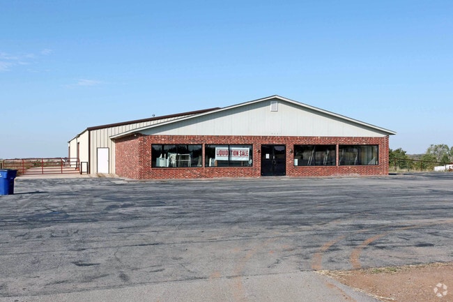
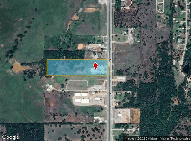
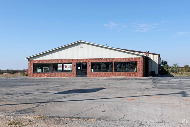
Property Record
5701 N Highway 81, Duncan, OK 73533
NEARBY LISTINGS FOR SALE OR LEASE
Property Detail
5701 N Highway 81
1999-18-01N-07W-1-013-00
N/A
Autorepair
18-1N-7W N1/2 N1/2 SENE LESS E62.6 FOR HWY
X
Stephens
40137C0215F
Oklahoma
2024
7w
2025
9.51 AC
000800
Other Market Areas
10,080 SF
Duncan, OK
DEMOGRAPHICS near 5701 N Highway 81
1 Mile
3 Mile
5 Mile
2024 Total Population
698
7,748
24,564
2029 Population
704
7,946
25,536
Pop Growth 2024-2029
+ 0.86%
+ 2.56%
+ 3.96%
Average Age
46
45
42
2024 Total Households
301
3,309
10,009
HH Growth 2024-2029
+ 0.33%
+ 2.45%
+ 3.81%
Median Household Inc
$73,845
$73,594
$52,380
Avg Household Size
2.30
2.30
2.40
2024 Avg HH Vehicles
2.00
2.00
2.00
Median Home Value
$187,499
$185,663
$136,328
Median Year Built
1983
1978
1971
Nearby Places
Map Layers
Map Styles
 Street
 Aerial
- Restaurants
- Banks
- Shops
- Fitness
- Groceries
PUBLIC TRANSPORTATION
AIRPORT
Lawton-Fort Sill Regional
DRIVE
WALK
Distance
Lawton-Fort Sill Regional
43 min
31.2 mi
Freight Ports
Tulsa Port Of Catoosa
DRIVE
WALK
Distance
Tulsa Port Of Catoosa
219 min
200.1 mi
Nearby Properties
Address
Land Use
TOTAL SIZE
Lot Size
Zoning
Address
Land Use
TOTAL SIZE
Lot Size
Zoning
61,546 SF
22.70 AC
Address
Land Use
TOTAL SIZE
Lot Size
Zoning
82,956 SF
11.54 AC
C1
Address
Land Use
TOTAL SIZE
Lot Size
Zoning
32,998 SF
2.64 AC
C2
Address
Land Use
TOTAL SIZE
Lot Size
Zoning
154 SF
14 AC
Address
Land Use
TOTAL SIZE
Lot Size
Zoning
160 SF
43.16 AC
Address
Land Use
TOTAL SIZE
Lot Size
Zoning
1,500 SF
5 AC
C2
Address
Land Use
TOTAL SIZE
Lot Size
Zoning
9,014 SF
1.77 AC
C1
Address
Land Use
TOTAL SIZE
Lot Size
Zoning
33,953 SF
5.94 AC
R1
Address
Land Use
TOTAL SIZE
Lot Size
Zoning
5,037 SF
13.41 AC
Address
Land Use
TOTAL SIZE
Lot Size
Zoning
14,352 SF
10 AC
R1
Address
Land Use
TOTAL SIZE
Lot Size
Zoning
2,989 SF
13.49 AC
C2
Address
Land Use
TOTAL SIZE
Lot Size
Zoning
20,966 SF
5 AC
R1
Address
Land Use
TOTAL SIZE
Lot Size
Zoning
4,000 SF
76.61 AC
C1
Address
Land Use
TOTAL SIZE
Lot Size
Zoning
1,099 SF
6 AC
R1
Address
Land Use
TOTAL SIZE
Lot Size
Zoning
8,137 SF
7.57 AC
R1
Address
Land Use
TOTAL SIZE
Lot Size
Zoning
28,165 SF
2.68 AC
C2
Address
Land Use
TOTAL SIZE
Lot Size
Zoning
10,418 SF
3.39 AC
R1
Address
Land Use
TOTAL SIZE
Lot Size
Zoning
160 SF
6.70 AC
C2
Address
Land Use
TOTAL SIZE
Lot Size
Zoning
3,016 SF
1.64 AC
C1
Address
Land Use
TOTAL SIZE
Lot Size
Zoning
8,218 SF
0.94 AC
R1
Address
Land Use
TOTAL SIZE
Lot Size
Zoning
4,141 SF
1.29 AC
Address
Land Use
TOTAL SIZE
Lot Size
Zoning
50,376 SF
2.16 AC
Address
Land Use
TOTAL SIZE
Lot Size
Zoning
532 SF
40.47 AC
C1
Address
Land Use
TOTAL SIZE
Lot Size
Zoning
3,766 SF
1.70 AC
R1
Address
Land Use
TOTAL SIZE
Lot Size
Zoning
5,250 SF
4.17 AC
C1
Address
Land Use
TOTAL SIZE
Lot Size
Zoning
890 SF
3.76 AC
R1
Address
Land Use
TOTAL SIZE
Lot Size
Zoning
3,395 SF
2.54 AC
Address
Land Use
TOTAL SIZE
Lot Size
Zoning
7,279 SF
2.16 AC
R1
Address
Land Use
TOTAL SIZE
Lot Size
Zoning
15,444 SF
5.01 AC
C1
The World's #1 Commercial Real Estate Marketplace
Connect with us
© 2026 CoStar Group
The information above has been obtained from sources believed reliable. While we do not doubt its accuracy we have not verified it and make no guarantee, warranty or representation about it. It is your responsibility to independently confirm its accuracy and completeness. Any projections, opinions, assumptions, or estimates used are for example only and do not represent the current or future performance of the property. The value of this transaction to you depends on tax and other factors which should be evaluated by your tax, financial, and legal advisors. You and your advisors should conduct a careful, independent investigation of the property to determine to your satisfaction the suitability of the property for your needs.