Property Record
Various, Milwaukee, WI 53217

NEARBY LISTINGS FOR SALE OR LEASE
Property Detail
Various
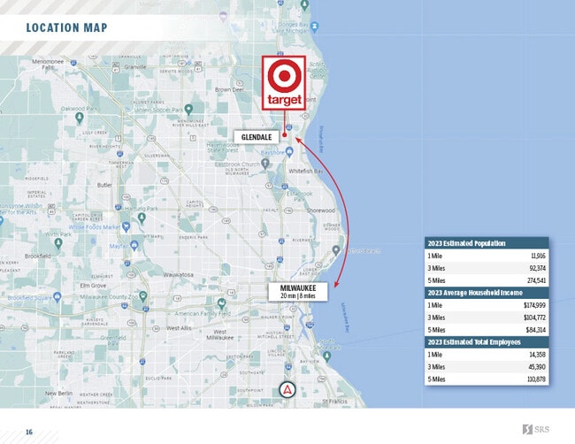
Milwaukee/Madison
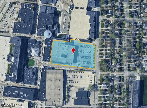
Certifield Survey Map No 9254
Milwaukee-Waukesha, WI
CERTIFIED SURVEY MAP NO 9254 SW PTS OF SE 1/4 SEC 29-8-22 LOT 8 OLD: PT GOV LTS 3 & 4 SE1/4 29-8-22 COM SW COR SD SE1/4 TH NLY ALG W LI OF SD SE1/4 828.12FT TO S LI OF N 15 AC OF GOV LT 4 TH ELY ALG SD LI 390.12FT TO POB TH NELY 319.50FT TH NWLY 346.
166-8021-000
Milwaukee
Commercialnec
Wisconsin
2024
8,3,4
2024
3.57 AC
060200
North Shore
128,512 SF
DEMOGRAPHICS near Various
1 Mile
3 Mile
5 Mile
2024 Total Population
10,288
92,845
279,417
2029 Population
9,979
91,255
275,200
Pop Growth 2024-2029
(3.00%)
(1.71%)
(1.51%)
Average Age
40
38
37
2024 Total Households
4,030
38,464
115,566
HH Growth 2024-2029
(2.95%)
(1.85%)
(1.66%)
Median Household Inc
$111,991
$54,461
$47,542
Avg Household Size
2.50
2.40
2.30
2024 Avg HH Vehicles
2.00
1.00
1.00
Median Home Value
$369,791
$256,861
$186,639
Median Year Built
1950
1949
1950
Nearby Places
Map Layers
Map Styles
 Street
 Aerial
- Restaurants
- Banks
- Shops
- Fitness
- Groceries
PUBLIC TRANSPORTATION
COMMUTER RAIL
Milwaukee (Empire Builder - Amtrak)
DRIVE
WALK
Distance
Milwaukee (Empire Builder - Amtrak)
13 min
6.9 mi
AIRPORT
General Mitchell International
DRIVE
WALK
Distance
General Mitchell International
23 min
13.5 mi
Freight Ports
Port Milwaukee
DRIVE
WALK
Distance
Port Milwaukee
16 min
9.4 mi
SALE & LEASE HISTORY
LISTING DATE
SALE/LEASE

Feb 26, 2024
For Sale
Nearby Properties
Address
Land Use
TOTAL SIZE
Lot Size
Zoning
Address
Land Use
TOTAL SIZE
Lot Size
Zoning
305,573 SF
3.20 AC
Address
Land Use
TOTAL SIZE
Lot Size
Zoning
66,245 SF
10.21 AC
Address
Land Use
TOTAL SIZE
Lot Size
Zoning
527,776 SF
33.23 AC
Address
Land Use
TOTAL SIZE
Lot Size
Zoning
85,000 SF
1.13 AC
Address
Land Use
TOTAL SIZE
Lot Size
Zoning
19.64 AC
Address
Land Use
TOTAL SIZE
Lot Size
Zoning
685,390 SF
26.20 AC
Address
Land Use
TOTAL SIZE
Lot Size
Zoning
152,640 SF
10.50 AC
Address
Land Use
TOTAL SIZE
Lot Size
Zoning
171,170 SF
25.88 AC
Address
Land Use
TOTAL SIZE
Lot Size
Zoning
224,756 SF
12 AC
RESIDENTIA
Address
Land Use
TOTAL SIZE
Lot Size
Zoning
145,218 SF
10.23 AC
Address
Land Use
TOTAL SIZE
Lot Size
Zoning
145,605 SF
2.64 AC
Address
Land Use
TOTAL SIZE
Lot Size
Zoning
241,520 SF
6.60 AC
Address
Land Use
TOTAL SIZE
Lot Size
Zoning
Address
Land Use
TOTAL SIZE
Lot Size
Zoning
165,296 SF
1.04 AC
Address
Land Use
TOTAL SIZE
Lot Size
Zoning
294,553 SF
6.19 AC
Address
Land Use
TOTAL SIZE
Lot Size
Zoning
113,542 SF
2.31 AC
Address
Land Use
TOTAL SIZE
Lot Size
Zoning
213,218 SF
11 AC
Address
Land Use
TOTAL SIZE
Lot Size
Zoning
235,364 SF
7.20 AC
Address
Land Use
TOTAL SIZE
Lot Size
Zoning
90,714 SF
4.18 AC
Address
Land Use
TOTAL SIZE
Lot Size
Zoning
195,507 SF
1.92 AC
Address
Land Use
TOTAL SIZE
Lot Size
Zoning
2.15 AC
RT4
Address
Land Use
TOTAL SIZE
Lot Size
Zoning
72,676 SF
6.22 AC
Address
Land Use
TOTAL SIZE
Lot Size
Zoning
66.42 AC
IL1
Address
Land Use
TOTAL SIZE
Lot Size
Zoning
74,526 SF
5.42 AC
Address
Land Use
TOTAL SIZE
Lot Size
Zoning
194,400 SF
8.09 AC
Address
Land Use
TOTAL SIZE
Lot Size
Zoning
140,418 SF
1.25 AC
Address
Land Use
TOTAL SIZE
Lot Size
Zoning
137,100 SF
6.69 AC
IL2
Address
Land Use
TOTAL SIZE
Lot Size
Zoning
48,540 SF
4.28 AC
Address
Land Use
TOTAL SIZE
Lot Size
Zoning
127,584 SF
3.28 AC
Address
Land Use
TOTAL SIZE
Lot Size
Zoning
18.54 AC
RS6
The World's #1 Commercial Real Estate Marketplace
Connect with us
© 2026 CoStar Group
The information above has been obtained from sources believed reliable. While we do not doubt its accuracy we have not verified it and make no guarantee, warranty or representation about it. It is your responsibility to independently confirm its accuracy and completeness. Any projections, opinions, assumptions, or estimates used are for example only and do not represent the current or future performance of the property. The value of this transaction to you depends on tax and other factors which should be evaluated by your tax, financial, and legal advisors. You and your advisors should conduct a careful, independent investigation of the property to determine to your satisfaction the suitability of the property for your needs.