Property Record
5701 Park Ave, Des Moines, IA 50321
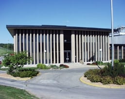

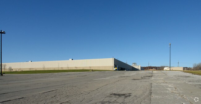
Property Detail
5701 Park Ave
010-06956001000
PARCEL 2022-1142 BK 19419 PG 399 SE 1/4 SEC 14-78-25
Warehouse
Polk
M-1
Iowa
B and X Area of moderate flood hazard, usually the area between the limits of the 100-year and 500-year floods.
26.06 AC
2023
South
2025
Des Moines
004001
Des Moines-West Des Moines, IA
526,295 SF
NEARBY LISTINGS FOR SALE OR LEASE
DEMOGRAPHICS near 5701 Park Ave
1 mile
3 mile
5 mile
2025 Total Population
1,344
42,741
185,796
2030 Population
1,405
44,527
194,212
Pop Growth 2025-2030
+ 4.54%
+ 4.18%
+ 4.53%
Average Age
37
41
39
2025 Total Households
575
19,368
81,587
HH Growth 2025-2030
+ 4.70%
+ 4.27%
+ 4.82%
Median Household Inc
$60,227
$77,344
$70,511
Avg Household Size
2.30
2.10
2.20
2025 Avg HH Vehicles
2.00
2.00
2.00
Median Home Value
$306,667
$296,864
$251,020
Median Year Built
1989
1970
1971
Nearby Places
Map Layers
Map Styles
 Street
 Aerial
Layers
 Traffic
 Biking
Places
Listings with unknown addresses are not visible on the map
- Restaurants
- Banks
- Shops
- Fitness
- Groceries
PUBLIC TRANSPORTATION
AIRPORT
Des Moines International
Drive
Walk
Distance
Des Moines International
7 min
3.2 mi
Freight Ports
Port Milwaukee
Drive
Walk
Distance
Port Milwaukee
425 min
380.5 mi
SALE & LEASE HISTORY
LISTING DATE
SALE/LEASE

Sep 25, 2016
For Lease
Nearby Properties
Address
Land Use
TOTAL SIZE
Lot Size
Zoning
Address
Land Use
TOTAL SIZE
Lot Size
Zoning
351,427 SF
57.41 AC
Address
Land Use
TOTAL SIZE
Lot Size
Zoning
283,760 SF
27.19 AC
Address
Land Use
TOTAL SIZE
Lot Size
Zoning
283,760 SF
14.96 AC
Address
Land Use
TOTAL SIZE
Lot Size
Zoning
227,640 SF
19.48 AC
Address
Land Use
TOTAL SIZE
Lot Size
Zoning
594,010 SF
24.40 AC
R1-80
Address
Land Use
TOTAL SIZE
Lot Size
Zoning
289,527 SF
11.23 AC
PUD
Address
Land Use
TOTAL SIZE
Lot Size
Zoning
302,800 SF
20.85 AC
Address
Land Use
TOTAL SIZE
Lot Size
Zoning
444,073 SF
28.05 AC
RH
Address
Land Use
TOTAL SIZE
Lot Size
Zoning
203,710 SF
26.88 AC
Address
Land Use
TOTAL SIZE
Lot Size
Zoning
150,640 SF
2.46 AC
PUD
Address
Land Use
TOTAL SIZE
Lot Size
Zoning
235,620 SF
13.18 AC
RH
Address
Land Use
TOTAL SIZE
Lot Size
Zoning
175,021 SF
6.76 AC
Address
Land Use
TOTAL SIZE
Lot Size
Zoning
298,528 SF
3.79 AC
R-4
Address
Land Use
TOTAL SIZE
Lot Size
Zoning
247,414 SF
15.83 AC
RH
Address
Land Use
TOTAL SIZE
Lot Size
Zoning
122,676 SF
1.16 AC
Address
Land Use
TOTAL SIZE
Lot Size
Zoning
192,222 SF
9.27 AC
Address
Land Use
TOTAL SIZE
Lot Size
Zoning
189,506 SF
11.78 AC
PUD HD
Address
Land Use
TOTAL SIZE
Lot Size
Zoning
168,556 SF
10.92 AC
RH
Address
Land Use
TOTAL SIZE
Lot Size
Zoning
61,320 SF
8.13 AC
Address
Land Use
TOTAL SIZE
Lot Size
Zoning
264,656 SF
9.38 AC
RH
Address
Land Use
TOTAL SIZE
Lot Size
Zoning
260,420 SF
18.17 AC
R-3
Address
Land Use
TOTAL SIZE
Lot Size
Zoning
96,860 SF
7.98 AC
R-1
Address
Land Use
TOTAL SIZE
Lot Size
Zoning
658,855 SF
47.73 AC
M-1
Address
Land Use
TOTAL SIZE
Lot Size
Zoning
191,668 SF
8.27 AC
R-6
Address
Land Use
TOTAL SIZE
Lot Size
Zoning
75,075 SF
6.09 AC
PUD
Address
Land Use
TOTAL SIZE
Lot Size
Zoning
78,390 SF
3.04 AC
R1-80
Address
Land Use
TOTAL SIZE
Lot Size
Zoning
149,564 SF
22.29 AC
PUD
Address
Land Use
TOTAL SIZE
Lot Size
Zoning
202,212 SF
19.03 AC
CC
Address
Land Use
TOTAL SIZE
Lot Size
Zoning
107,810 SF
9.63 AC
PUD MD
The World's #1 Commercial Real Estate Marketplace
Connect with us
© 2026 CoStar Group
The information above has been obtained from sources believed reliable. While we do not doubt its accuracy we have not verified it and make no guarantee, warranty or representation about it. It is your responsibility to independently confirm its accuracy and completeness. Any projections, opinions, assumptions, or estimates used are for example only and do not represent the current or future performance of the property. The value of this transaction to you depends on tax and other factors which should be evaluated by your tax, financial, and legal advisors. You and your advisors should conduct a careful, independent investigation of the property to determine to your satisfaction the suitability of the property for your needs.