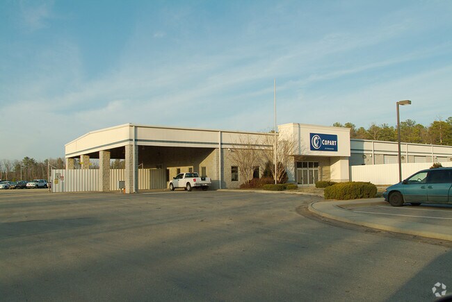
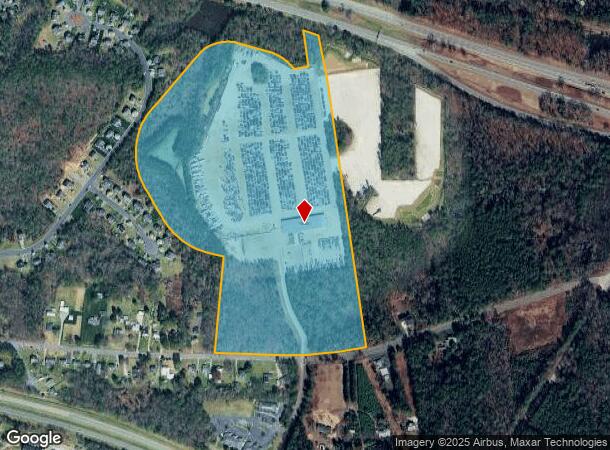
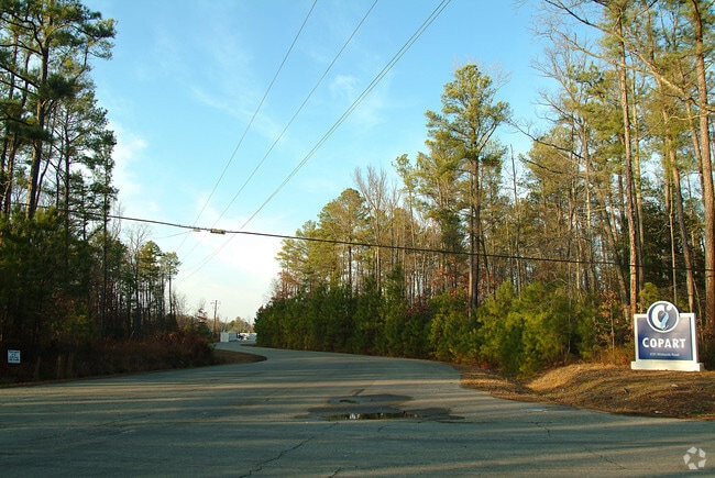
Property Record
5701 Whiteside Rd, Sandston, VA 23150
NEARBY LISTINGS FOR SALE OR LEASE
Property Detail
5701 Whiteside Rd
833-716-9203
01650A0000 0012B; N L WILLIAMSBURG RD AC 45.207 15 B2 44
Multipleuses
Henrico
X
Virginia
51085C0445C
45.21 AC
2025
East End
2025
Richmond VA
201701
Richmond, VA
19,280 SF
DEMOGRAPHICS near 5701 Whiteside Rd
1 Mile
3 Mile
5 Mile
2024 Total Population
3,729
17,144
45,342
2029 Population
3,698
17,054
45,506
Pop Growth 2024-2029
(0.83%)
(0.52%)
+ 0.36%
Average Age
40
40
41
2024 Total Households
1,545
6,947
18,331
HH Growth 2024-2029
(0.84%)
(0.55%)
+ 0.33%
Median Household Inc
$62,160
$59,080
$60,187
Avg Household Size
2.40
2.40
2.40
2024 Avg HH Vehicles
2.00
2.00
2.00
Median Home Value
$193,967
$175,466
$196,684
Median Year Built
1968
1974
1979
Nearby Places
Map Layers
Map Styles
 Street
 Aerial
- Restaurants
- Banks
- Shops
- Fitness
- Groceries
PUBLIC TRANSPORTATION
AIRPORT
Richmond International
DRIVE
WALK
Distance
Richmond International
7 min
2.6 mi
Freight Ports
Virginia Port Authority - Richmond
DRIVE
WALK
Distance
Virginia Port Authority - Richmond
22 min
14.6 mi
Nearby Properties
Address
Land Use
TOTAL SIZE
Lot Size
Zoning
Address
Land Use
TOTAL SIZE
Lot Size
Zoning
548,680 SF
2,298.89 AC
MIXE
Address
Land Use
TOTAL SIZE
Lot Size
Zoning
143,287 SF
56.39 AC
MIXE
Address
Land Use
TOTAL SIZE
Lot Size
Zoning
716,824 SF
60.89 AC
M-2C
Address
Land Use
TOTAL SIZE
Lot Size
Zoning
522,399 SF
58.07 AC
M-1
Address
Land Use
TOTAL SIZE
Lot Size
Zoning
322,000 SF
15.94 AC
M-1
Address
Land Use
TOTAL SIZE
Lot Size
Zoning
181,200 SF
14.74 AC
R-5
Address
Land Use
TOTAL SIZE
Lot Size
Zoning
142,379 SF
17.69 AC
M-1
Address
Land Use
TOTAL SIZE
Lot Size
Zoning
212,576 SF
94.90 AC
MIXE
Address
Land Use
TOTAL SIZE
Lot Size
Zoning
53,530 SF
4.50 AC
M-1C
Address
Land Use
TOTAL SIZE
Lot Size
Zoning
144,135 SF
9.72 AC
M-1
Address
Land Use
TOTAL SIZE
Lot Size
Zoning
63,700 SF
19.50 AC
A-1
Address
Land Use
TOTAL SIZE
Lot Size
Zoning
130,638 SF
11.06 AC
R-5
Address
Land Use
TOTAL SIZE
Lot Size
Zoning
1,546 SF
43.18 AC
MIXE
Address
Land Use
TOTAL SIZE
Lot Size
Zoning
87,384 SF
8.05 AC
R-5
Address
Land Use
TOTAL SIZE
Lot Size
Zoning
80,815 SF
3.25 AC
M-1
Address
Land Use
TOTAL SIZE
Lot Size
Zoning
120,860 SF
15.03 AC
M1-C
Address
Land Use
TOTAL SIZE
Lot Size
Zoning
42,755 SF
103.73 AC
M-1
Address
Land Use
TOTAL SIZE
Lot Size
Zoning
100,240 SF
7.81 AC
R-5
Address
Land Use
TOTAL SIZE
Lot Size
Zoning
123,668 SF
125.60 AC
A-1
Address
Land Use
TOTAL SIZE
Lot Size
Zoning
74,710 SF
3.23 AC
B-3
Address
Land Use
TOTAL SIZE
Lot Size
Zoning
182,864 SF
16.95 AC
M-2
Address
Land Use
TOTAL SIZE
Lot Size
Zoning
230,978 SF
23.37 AC
M-1C
Address
Land Use
TOTAL SIZE
Lot Size
Zoning
88,367 SF
4.01 AC
M-1
Address
Land Use
TOTAL SIZE
Lot Size
Zoning
108,900 SF
7.58 AC
R-5
Address
Land Use
TOTAL SIZE
Lot Size
Zoning
141,588 SF
12.66 AC
M-1
Address
Land Use
TOTAL SIZE
Lot Size
Zoning
50,190 SF
14.43 AC
R-3
Address
Land Use
TOTAL SIZE
Lot Size
Zoning
94,939 SF
4.45 AC
MIXE
Address
Land Use
TOTAL SIZE
Lot Size
Zoning
55,272 SF
3.07 AC
M-1C
Address
Land Use
TOTAL SIZE
Lot Size
Zoning
56,797 SF
1.91 AC
B-3
Address
Land Use
TOTAL SIZE
Lot Size
Zoning
99,398 SF
6.97 AC
M-1
The World's #1 Commercial Real Estate Marketplace
Connect with us
© 2026 CoStar Group
The information above has been obtained from sources believed reliable. While we do not doubt its accuracy we have not verified it and make no guarantee, warranty or representation about it. It is your responsibility to independently confirm its accuracy and completeness. Any projections, opinions, assumptions, or estimates used are for example only and do not represent the current or future performance of the property. The value of this transaction to you depends on tax and other factors which should be evaluated by your tax, financial, and legal advisors. You and your advisors should conduct a careful, independent investigation of the property to determine to your satisfaction the suitability of the property for your needs.