Property Record
5704 Millstream Rd, Whitsett, NC 27377
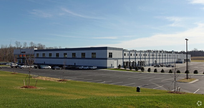


Property Detail
5704 Millstream Rd
0108813
PRECOR/ROCK CREEK INDUSTRIAL PARK PL:176-68
Industrialgeneral
GUILFORD
LI
North Carolina
AE The base floodplain where base flood elevations are provided. AE Zones are now used on new format FIRMs instead of A1-A30 Zones.
19
2024
38.75 AC
2025
SE Guilford County
017200
Greensboro/Winston-Salem
235,503 SF
Greensboro-High Point, NC
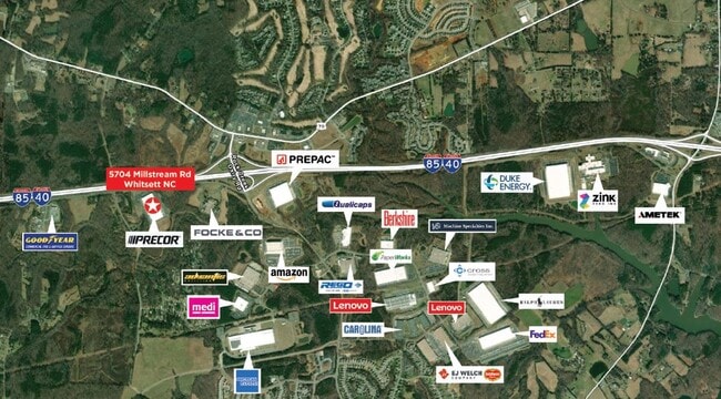
NEARBY LISTINGS FOR SALE OR LEASE
DEMOGRAPHICS near 5704 Millstream Rd
1 mile
3 mile
5 mile
2025 Total Population
1,498
12,068
31,866
2030 Population
1,558
12,519
33,168
Pop Growth 2025-2030
+ 4.01%
+ 3.74%
+ 4.09%
Average Age
43
41
40
2025 Total Households
620
4,815
12,463
HH Growth 2025-2030
+ 4.35%
+ 3.90%
+ 4.26%
Median Household Inc
$92,694
$78,462
$78,685
Avg Household Size
2.40
2.50
2.50
2025 Avg HH Vehicles
2.00
2.00
2.00
Median Home Value
$299,366
$287,884
$285,829
Median Year Built
1999
2000
2001
Nearby Places
Map Layers
Map Styles
 Street
 Aerial
Layers
 Traffic
 Biking
Places
Listings with unknown addresses are not visible on the map
- Restaurants
- Banks
- Shops
- Fitness
- Groceries
PUBLIC TRANSPORTATION
AIRPORT
Piedmont Triad International
Drive
Walk
Distance
Piedmont Triad International
38 min
22.8 mi
SALE & LEASE HISTORY
LISTING DATE
SALE/LEASE

Mar 31, 2023
For Lease
Mar 30, 2023
For Lease
Nearby Properties
Address
Land Use
TOTAL SIZE
Lot Size
Zoning
Address
Land Use
TOTAL SIZE
Lot Size
Zoning
495,280 SF
105.18 AC
LI
Address
Land Use
TOTAL SIZE
Lot Size
Zoning
414,500 SF
103.57 AC
PI
Address
Land Use
TOTAL SIZE
Lot Size
Zoning
531,300 SF
29.40 AC
LI
Address
Land Use
TOTAL SIZE
Lot Size
Zoning
297,670 SF
37.41 AC
LI
Address
Land Use
TOTAL SIZE
Lot Size
Zoning
475,200 SF
46.54 AC
LI
Address
Land Use
TOTAL SIZE
Lot Size
Zoning
93,763 SF
33.51 AC
LI
Address
Land Use
TOTAL SIZE
Lot Size
Zoning
300,464 SF
19.67 AC
LI
Address
Land Use
TOTAL SIZE
Lot Size
Zoning
177,717 SF
20.81 AC
BP
Address
Land Use
TOTAL SIZE
Lot Size
Zoning
246,317 SF
18.72 AC
PD-R
Address
Land Use
TOTAL SIZE
Lot Size
Zoning
260,000 SF
20.35 AC
LI
Address
Land Use
TOTAL SIZE
Lot Size
Zoning
240,155 SF
21.72 AC
LI
Address
Land Use
TOTAL SIZE
Lot Size
Zoning
162,161 SF
19.18 AC
RM-8
Address
Land Use
TOTAL SIZE
Lot Size
Zoning
652,985 SF
104.62 AC
BP
Address
Land Use
TOTAL SIZE
Lot Size
Zoning
271,850 SF
25.24 AC
LI
Address
Land Use
TOTAL SIZE
Lot Size
Zoning
85,715 SF
15.34 AC
PUD
Address
Land Use
TOTAL SIZE
Lot Size
Zoning
215,233 SF
18.98 AC
LI
Address
Land Use
TOTAL SIZE
Lot Size
Zoning
92,497 SF
22.35 AC
LI
Address
Land Use
TOTAL SIZE
Lot Size
Zoning
146,028 SF
11.36 AC
BP
Address
Land Use
TOTAL SIZE
Lot Size
Zoning
86,400 SF
7.11 AC
BP
Address
Land Use
TOTAL SIZE
Lot Size
Zoning
57,829 SF
2.65 AC
LI
Address
Land Use
TOTAL SIZE
Lot Size
Zoning
158,080 SF
16.35 AC
LI
Address
Land Use
TOTAL SIZE
Lot Size
Zoning
90,000 SF
8.95 AC
LI
Address
Land Use
TOTAL SIZE
Lot Size
Zoning
37,100 SF
3.53 AC
HB
Address
Land Use
TOTAL SIZE
Lot Size
Zoning
218,126 SF
22.41 AC
LI
Address
Land Use
TOTAL SIZE
Lot Size
Zoning
136,934 SF
14.80 AC
LI
Address
Land Use
TOTAL SIZE
Lot Size
Zoning
112,837 SF
15.22 AC
LI
Address
Land Use
TOTAL SIZE
Lot Size
Zoning
109,962 SF
15 AC
LI
Address
Land Use
TOTAL SIZE
Lot Size
Zoning
58,144 SF
10.84 AC
CD-SC
Address
Land Use
TOTAL SIZE
Lot Size
Zoning
45,878 SF
1.68 AC
LI
The World's #1 Commercial Real Estate Marketplace
Connect with us
© 2026 CoStar Group
The information above has been obtained from sources believed reliable. While we do not doubt its accuracy we have not verified it and make no guarantee, warranty or representation about it. It is your responsibility to independently confirm its accuracy and completeness. Any projections, opinions, assumptions, or estimates used are for example only and do not represent the current or future performance of the property. The value of this transaction to you depends on tax and other factors which should be evaluated by your tax, financial, and legal advisors. You and your advisors should conduct a careful, independent investigation of the property to determine to your satisfaction the suitability of the property for your needs.