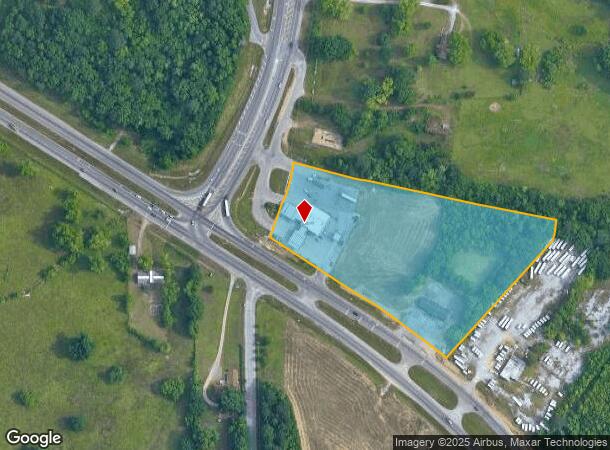
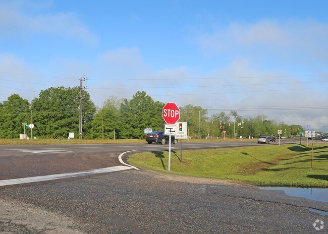
Property Record
5705 Taylor Rd, Montgomery, AL 36116

NEARBY LISTINGS FOR SALE OR LEASE
Property Detail
5705 Taylor Rd
Montgomery, AL
Racetrac Inc 2
16-03-07-1-000-004.000
SEC 7 T15N R19E 2.94 AC IN W1/2 OF NE1/4 1603071000004000
Conveniencestore
Montgomery
X
Alabama
01101C0237H
1
2025
7.21 AC
2025
North Montgomery
005614
Montgomery
DEMOGRAPHICS near 5705 Taylor Rd
1 Mile
3 Mile
5 Mile
2024 Total Population
1,302
21,923
70,359
2029 Population
1,312
21,329
67,918
Pop Growth 2024-2029
+ 0.77%
(2.71%)
(3.47%)
Average Age
37
35
37
2024 Total Households
542
8,872
29,598
HH Growth 2024-2029
+ 0.92%
(2.80%)
(3.60%)
Median Household Inc
$80,555
$57,144
$55,779
Avg Household Size
2.40
2.40
2.30
2024 Avg HH Vehicles
2.00
2.00
2.00
Median Home Value
$341,156
$178,161
$179,307
Median Year Built
2008
1994
1989
Nearby Places
Map Layers
Map Styles
 Street
 Aerial
- Restaurants
- Banks
- Shops
- Fitness
- Groceries
PUBLIC TRANSPORTATION
AIRPORT
Montgomery Regional (Dannelly Field)
DRIVE
WALK
Distance
Montgomery Regional (Dannelly Field)
18 min
13.8 mi
Freight Ports
Port of Panama City
DRIVE
WALK
Distance
Port of Panama City
224 min
178.6 mi
Nearby Properties
Address
Land Use
TOTAL SIZE
Lot Size
Zoning
Address
Land Use
TOTAL SIZE
Lot Size
Zoning
4,998 SF
27.50 AC
R-65-M
Address
Land Use
TOTAL SIZE
Lot Size
Zoning
47,292 SF
63.99 AC
Address
Land Use
TOTAL SIZE
Lot Size
Zoning
23,642 SF
13.70 AC
PUD
Address
Land Use
TOTAL SIZE
Lot Size
Zoning
10,317 SF
16.70 AC
AGR-1
Address
Land Use
TOTAL SIZE
Lot Size
Zoning
30,536 SF
18.06 AC
AGR-1
Address
Land Use
TOTAL SIZE
Lot Size
Zoning
56,446 SF
18.67 AC
PUD
Address
Land Use
TOTAL SIZE
Lot Size
Zoning
208,584 SF
21.10 AC
B-3
Address
Land Use
TOTAL SIZE
Lot Size
Zoning
21,634 SF
6.64 AC
Address
Land Use
TOTAL SIZE
Lot Size
Zoning
3,312 SF
15.73 AC
R-65-M
Address
Land Use
TOTAL SIZE
Lot Size
Zoning
7,683 SF
8.11 AC
PUD
Address
Land Use
TOTAL SIZE
Lot Size
Zoning
49,810 SF
12.40 AC
B-2
Address
Land Use
TOTAL SIZE
Lot Size
Zoning
2,164 SF
7.50 AC
R-60-A
Address
Land Use
TOTAL SIZE
Lot Size
Zoning
44,082 SF
5.95 AC
Address
Land Use
TOTAL SIZE
Lot Size
Zoning
1,747 SF
7 AC
R-65-M
Address
Land Use
TOTAL SIZE
Lot Size
Zoning
918 SF
8.86 AC
R-65-M
Address
Land Use
TOTAL SIZE
Lot Size
Zoning
10,314 SF
6.92 AC
PUD
Address
Land Use
TOTAL SIZE
Lot Size
Zoning
13,369 SF
14 AC
B-3
Address
Land Use
TOTAL SIZE
Lot Size
Zoning
5,400 SF
12.61 AC
M-1
Address
Land Use
TOTAL SIZE
Lot Size
Zoning
8,580 SF
6.80 AC
R-65-M
Address
Land Use
TOTAL SIZE
Lot Size
Zoning
6,866 SF
5.39 AC
PUD
Address
Land Use
TOTAL SIZE
Lot Size
Zoning
3,358 SF
123.85 AC
AGR-1
Address
Land Use
TOTAL SIZE
Lot Size
Zoning
962 SF
4 AC
M-1
Address
Land Use
TOTAL SIZE
Lot Size
Zoning
6,330 SF
7.20 AC
R-65-M
Address
Land Use
TOTAL SIZE
Lot Size
Zoning
84,279 SF
14.27 AC
Address
Land Use
TOTAL SIZE
Lot Size
Zoning
68,187 SF
8.10 AC
AGR-1
Address
Land Use
TOTAL SIZE
Lot Size
Zoning
1,483 SF
5.55 AC
R-75-S
Address
Land Use
TOTAL SIZE
Lot Size
Zoning
7,992 SF
4.27 AC
R-65-S
Address
Land Use
TOTAL SIZE
Lot Size
Zoning
18,892 SF
9 AC
B-4
Address
Land Use
TOTAL SIZE
Lot Size
Zoning
1,585 SF
13.86 AC
PUD
Address
Land Use
TOTAL SIZE
Lot Size
Zoning
1,397 SF
3.30 AC
B-4
The World's #1 Commercial Real Estate Marketplace
Connect with us
© 2026 CoStar Group
The information above has been obtained from sources believed reliable. While we do not doubt its accuracy we have not verified it and make no guarantee, warranty or representation about it. It is your responsibility to independently confirm its accuracy and completeness. Any projections, opinions, assumptions, or estimates used are for example only and do not represent the current or future performance of the property. The value of this transaction to you depends on tax and other factors which should be evaluated by your tax, financial, and legal advisors. You and your advisors should conduct a careful, independent investigation of the property to determine to your satisfaction the suitability of the property for your needs.