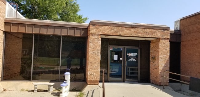
Property Record
5705 W 65Th St, Little Rock, AR 72209

NEARBY LISTINGS FOR SALE OR LEASE
Property Detail
5705 W 65Th St
34L-384-01-002-00
Victory Lots 1 & 2
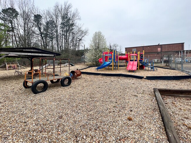
Daycare
Pulaski
X
Arkansas
05119C0454J
2
2025
3.16 AC
2025
Southwest
002002
Little Rock/N Little Rock
27,034 SF
Little Rock-North Little Rock-Conway, AR
DEMOGRAPHICS near 5705 W 65Th St
1 Mile
3 Mile
5 Mile
2024 Total Population
9,449
48,318
113,729
2029 Population
9,511
48,752
114,805
Pop Growth 2024-2029
+ 0.66%
+ 0.90%
+ 0.95%
Average Age
34
35
38
2024 Total Households
3,506
18,415
47,093
HH Growth 2024-2029
+ 0.60%
+ 1.13%
+ 1.02%
Median Household Inc
$36,303
$39,980
$43,043
Avg Household Size
2.60
2.50
2.20
2024 Avg HH Vehicles
2.00
2.00
2.00
Median Home Value
$63,970
$87,889
$132,437
Median Year Built
1969
1972
1971
Nearby Places
Map Layers
Map Styles
 Street
 Aerial
- Restaurants
- Banks
- Shops
- Fitness
- Groceries
PUBLIC TRANSPORTATION
COMMUTER RAIL
Little Rock Union Station (Texas Eagle - Amtrak)
DRIVE
WALK
Distance
Little Rock Union Station (Texas Eagle - Amtrak)
13 min
8.6 mi
AIRPORT
Bill and Hillary Clinton Ntl/Adams Field
DRIVE
WALK
Distance
Bill and Hillary Clinton Ntl/Adams Field
13 min
8.5 mi
Freight Ports
Port of Shreveport
DRIVE
WALK
Distance
Port of Shreveport
243 min
227.0 mi
SALE & LEASE HISTORY
LISTING DATE
SALE/LEASE

Mar 06, 2023
For Sale
Jul 31, 2020
For Sale
Jan 30, 2024
For Sale
Aug 21, 2018
For Sale
Nearby Properties
Address
Land Use
TOTAL SIZE
Lot Size
Zoning
Address
Land Use
TOTAL SIZE
Lot Size
Zoning
10 SF
29.02 AC
Address
Land Use
TOTAL SIZE
Lot Size
Zoning
88,687 SF
1.67 AC
Address
Land Use
TOTAL SIZE
Lot Size
Zoning
79,751 SF
28.57 AC
Address
Land Use
TOTAL SIZE
Lot Size
Zoning
239,345 SF
19.70 AC
Address
Land Use
TOTAL SIZE
Lot Size
Zoning
34,925 SF
12.59 AC
Address
Land Use
TOTAL SIZE
Lot Size
Zoning
83,466 SF
5.46 AC
Address
Land Use
TOTAL SIZE
Lot Size
Zoning
41,652 SF
10.86 AC
Address
Land Use
TOTAL SIZE
Lot Size
Zoning
50,433 SF
22.23 AC
Address
Land Use
TOTAL SIZE
Lot Size
Zoning
24,492 SF
8.92 AC
Address
Land Use
TOTAL SIZE
Lot Size
Zoning
201,499 SF
21.70 AC
Address
Land Use
TOTAL SIZE
Lot Size
Zoning
131,278 SF
6.37 AC
Address
Land Use
TOTAL SIZE
Lot Size
Zoning
139,410 SF
8.35 AC
Address
Land Use
TOTAL SIZE
Lot Size
Zoning
24,520 SF
10.92 AC
Address
Land Use
TOTAL SIZE
Lot Size
Zoning
6,161 SF
40.08 AC
Address
Land Use
TOTAL SIZE
Lot Size
Zoning
182,636 SF
16.86 AC
Address
Land Use
TOTAL SIZE
Lot Size
Zoning
152,350 SF
13.57 AC
Address
Land Use
TOTAL SIZE
Lot Size
Zoning
75,900 SF
20.18 AC
Address
Land Use
TOTAL SIZE
Lot Size
Zoning
35,069 SF
43.11 AC
Address
Land Use
TOTAL SIZE
Lot Size
Zoning
64,182 SF
17.80 AC
Address
Land Use
TOTAL SIZE
Lot Size
Zoning
59,076 SF
22.27 AC
Address
Land Use
TOTAL SIZE
Lot Size
Zoning
345,000 SF
13.21 AC
Address
Land Use
TOTAL SIZE
Lot Size
Zoning
33,216 SF
12.59 AC
Address
Land Use
TOTAL SIZE
Lot Size
Zoning
85,458 SF
9.86 AC
Address
Land Use
TOTAL SIZE
Lot Size
Zoning
10,629 SF
12 AC
Address
Land Use
TOTAL SIZE
Lot Size
Zoning
81,021 SF
10.28 AC
Address
Land Use
TOTAL SIZE
Lot Size
Zoning
62,326 SF
5.84 AC
Address
Land Use
TOTAL SIZE
Lot Size
Zoning
573,416 SF
57.83 AC
Address
Land Use
TOTAL SIZE
Lot Size
Zoning
16,200 SF
6.90 AC
Address
Land Use
TOTAL SIZE
Lot Size
Zoning
2,881 SF
14.04 AC
Address
Land Use
TOTAL SIZE
Lot Size
Zoning
16,032 SF
11.71 AC
The World's #1 Commercial Real Estate Marketplace
Connect with us
© 2026 CoStar Group
The information above has been obtained from sources believed reliable. While we do not doubt its accuracy we have not verified it and make no guarantee, warranty or representation about it. It is your responsibility to independently confirm its accuracy and completeness. Any projections, opinions, assumptions, or estimates used are for example only and do not represent the current or future performance of the property. The value of this transaction to you depends on tax and other factors which should be evaluated by your tax, financial, and legal advisors. You and your advisors should conduct a careful, independent investigation of the property to determine to your satisfaction the suitability of the property for your needs.