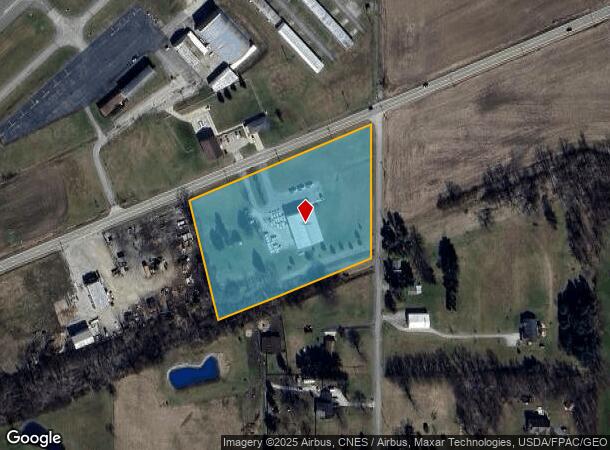
Property Record
5707 State Route 30, Galion, OH 44833
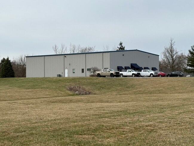

This Property Is For Sale
NEARBY LISTINGS FOR SALE OR LEASE
Property Detail
5707 State Route 30
040-29-184-16-000
NW A 5.096 LT 6 PT 5.096 ACRES SUBJ HWY EASE
Industrialgeneral
Richland
X
Ohio
39139C0115E
6
2024
5.10 AC
2024
Richland County
975100
Cleveland
11,680 SF
Mansfield, OH
DEMOGRAPHICS near 5707 State Route 30
1 Mile
3 Mile
5 Mile
2024 Total Population
169
7,470
23,242
2029 Population
171
7,472
23,197
Pop Growth 2024-2029
+ 1.18%
+ 0.03%
(0.19%)
Average Age
44
42
42
2024 Total Households
68
3,225
9,848
HH Growth 2024-2029
0.00%
(0.03%)
(0.23%)
Median Household Inc
$62,045
$52,567
$52,822
Avg Household Size
2.40
2.30
2.30
2024 Avg HH Vehicles
2.00
2.00
2.00
Median Home Value
$189,999
$113,097
$121,875
Median Year Built
1965
1963
1961
Nearby Places
Map Layers
Map Styles
 Street
 Aerial
- Restaurants
- Banks
- Shops
- Fitness
- Groceries
Nearby Properties
Address
Land Use
TOTAL SIZE
Lot Size
Zoning
Address
Land Use
TOTAL SIZE
Lot Size
Zoning
49.80 AC
Address
Land Use
TOTAL SIZE
Lot Size
Zoning
37,834 SF
2.09 AC
Address
Land Use
TOTAL SIZE
Lot Size
Zoning
20,502 SF
0.14 AC
Address
Land Use
TOTAL SIZE
Lot Size
Zoning
0.18 AC
Address
Land Use
TOTAL SIZE
Lot Size
Zoning
23,668 SF
0.32 AC
Address
Land Use
TOTAL SIZE
Lot Size
Zoning
12,137 SF
0.17 AC
Address
Land Use
TOTAL SIZE
Lot Size
Zoning
4.90 AC
Address
Land Use
TOTAL SIZE
Lot Size
Zoning
23,441 SF
0.17 AC
Address
Land Use
TOTAL SIZE
Lot Size
Zoning
16,665 SF
1.29 AC
Address
Land Use
TOTAL SIZE
Lot Size
Zoning
28.34 AC
Address
Land Use
TOTAL SIZE
Lot Size
Zoning
5.71 AC
Address
Land Use
TOTAL SIZE
Lot Size
Zoning
5,755 SF
0.23 AC
Address
Land Use
TOTAL SIZE
Lot Size
Zoning
696 SF
11.72 AC
Address
Land Use
TOTAL SIZE
Lot Size
Zoning
8,748 SF
1.91 AC
Address
Land Use
TOTAL SIZE
Lot Size
Zoning
1,764 SF
3.71 AC
Address
Land Use
TOTAL SIZE
Lot Size
Zoning
11,500 SF
2.32 AC
Address
Land Use
TOTAL SIZE
Lot Size
Zoning
21,014 SF
0.55 AC
Address
Land Use
TOTAL SIZE
Lot Size
Zoning
16,386 SF
0.22 AC
Address
Land Use
TOTAL SIZE
Lot Size
Zoning
3.74 AC
Address
Land Use
TOTAL SIZE
Lot Size
Zoning
2,688 SF
0.13 AC
Address
Land Use
TOTAL SIZE
Lot Size
Zoning
0.60 AC
Address
Land Use
TOTAL SIZE
Lot Size
Zoning
10,473 SF
0.18 AC
Address
Land Use
TOTAL SIZE
Lot Size
Zoning
10.20 AC
Address
Land Use
TOTAL SIZE
Lot Size
Zoning
1,288 SF
146 AC
Address
Land Use
TOTAL SIZE
Lot Size
Zoning
4.03 AC
Address
Land Use
TOTAL SIZE
Lot Size
Zoning
7,040 SF
0.17 AC
Address
Land Use
TOTAL SIZE
Lot Size
Zoning
11,150 SF
4.77 AC
Address
Land Use
TOTAL SIZE
Lot Size
Zoning
3.11 AC
Address
Land Use
TOTAL SIZE
Lot Size
Zoning
128.64 AC
Address
Land Use
TOTAL SIZE
Lot Size
Zoning
0.30 AC
The World's #1 Commercial Real Estate Marketplace
Connect with us
© 2025 CoStar Group
The information above has been obtained from sources believed reliable. While we do not doubt its accuracy we have not verified it and make no guarantee, warranty or representation about it. It is your responsibility to independently confirm its accuracy and completeness. Any projections, opinions, assumptions, or estimates used are for example only and do not represent the current or future performance of the property. The value of this transaction to you depends on tax and other factors which should be evaluated by your tax, financial, and legal advisors. You and your advisors should conduct a careful, independent investigation of the property to determine to your satisfaction the suitability of the property for your needs.