Property Record
5707 Taberg Rd, Rome, NY 13440

Save to a Folder
{{folder.Name}}
{{folder.ListingIds.length}} Properties
{{folder.ListingIds.length}} Property
Create a New Folder
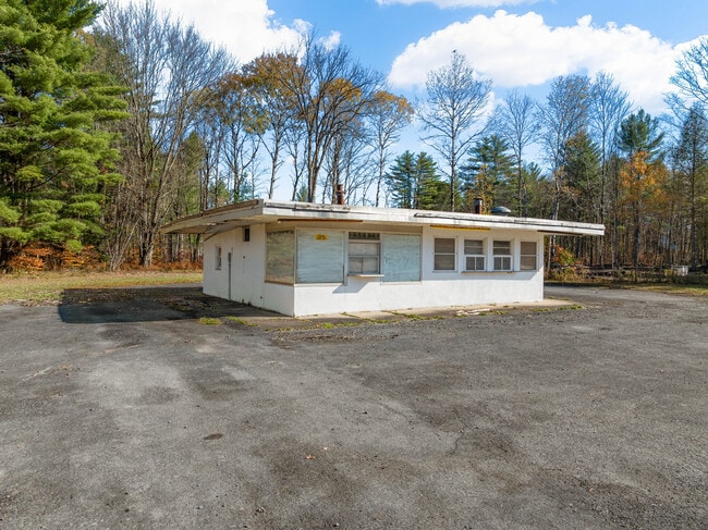
This Property Is For Sale
Property Detail
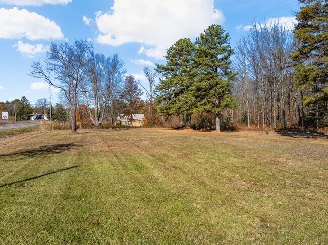
5707 Taberg Rd
222-000-0001-038-000-0000
ONEIDA
Restaurantdrivein
New York
C-2
38.000
B and X Area of moderate flood hazard, usually the area between the limits of the 100-year and 500-year floods.
1.57 AC
0
Greater Rome
2025
Utica/Rome
026300
Utica-Rome, NY
1,088 SF
NEARBY LISTINGS FOR SALE OR LEASE
DEMOGRAPHICS near 5707 Taberg Rd
1 mile
3 mile
5 mile
2025 Total Population
119
11,734
36,525
2030 Population
117
11,652
36,492
Pop Growth 2025-2030
(1.68%)
(0.70%)
(0.09%)
Average Age
46
42
42
2025 Total Households
51
5,030
15,198
HH Growth 2025-2030
(1.96%)
(0.66%)
(0.26%)
Median Household Inc
$83,333
$53,033
$55,840
Avg Household Size
2.30
2.30
2.20
2025 Avg HH Vehicles
2.00
1.00
2.00
Median Home Value
$173,333
$143,568
$162,528
Median Year Built
1965
1954
1956
Nearby Places
Map Layers
Map Styles
 Street
 Aerial
Layers
 Traffic
 Biking
Places
Listings with unknown addresses are not visible on the map
- Restaurants
- Banks
- Shops
- Fitness
- Groceries
PUBLIC TRANSPORTATION
COMMUTER RAIL
Drive
Walk
Distance
10 min
4.5 mi
AIRPORT
Syracuse Hancock International
Drive
Walk
Distance
Syracuse Hancock International
64 min
39.9 mi
Nearby Properties
Address
Land Use
TOTAL SIZE
Lot Size
Zoning
Address
Land Use
TOTAL SIZE
Lot Size
Zoning
112,259 SF
2.59 AC
C-3
Address
Land Use
TOTAL SIZE
Lot Size
Zoning
214,891 SF
22.90 AC
C-2
Address
Land Use
TOTAL SIZE
Lot Size
Zoning
131,001 SF
14.70 AC
R-2
Address
Land Use
TOTAL SIZE
Lot Size
Zoning
173,579 SF
14.46 AC
R-1-8
Address
Land Use
TOTAL SIZE
Lot Size
Zoning
41,262 SF
16.30 AC
R-1-8
Address
Land Use
TOTAL SIZE
Lot Size
Zoning
25,002 SF
6.53 AC
R-3
Address
Land Use
TOTAL SIZE
Lot Size
Zoning
49,643 SF
8 AC
C-1
Address
Land Use
TOTAL SIZE
Lot Size
Zoning
133,723 SF
9.28 AC
C-2
Address
Land Use
TOTAL SIZE
Lot Size
Zoning
287,725 SF
15.43 AC
I-G
Address
Land Use
TOTAL SIZE
Lot Size
Zoning
12,216 SF
15 AC
R-3
Address
Land Use
TOTAL SIZE
Lot Size
Zoning
66,876 SF
13 AC
R-1-8
Address
Land Use
TOTAL SIZE
Lot Size
Zoning
29,574 SF
49.10 AC
I
Address
Land Use
TOTAL SIZE
Lot Size
Zoning
30,056 SF
11.82 AC
C-2
Address
Land Use
TOTAL SIZE
Lot Size
Zoning
53,424 SF
4.38 AC
I-G
Address
Land Use
TOTAL SIZE
Lot Size
Zoning
6,422 SF
1.50 AC
C-2
Address
Land Use
TOTAL SIZE
Lot Size
Zoning
37,119 SF
7.40 AC
OS
Address
Land Use
TOTAL SIZE
Lot Size
Zoning
56,247 SF
2.06 AC
C-1
Address
Land Use
TOTAL SIZE
Lot Size
Zoning
74,075 SF
14.46 AC
C-2
Address
Land Use
TOTAL SIZE
Lot Size
Zoning
8,756 SF
2.50 AC
C-1
Address
Land Use
TOTAL SIZE
Lot Size
Zoning
7,056 SF
3.39 AC
R-2
Address
Land Use
TOTAL SIZE
Lot Size
Zoning
33,450 SF
6.99 AC
R-1-8
Address
Land Use
TOTAL SIZE
Lot Size
Zoning
16.65 AC
R-1-8
Address
Land Use
TOTAL SIZE
Lot Size
Zoning
132,400 SF
14.41 AC
C-2
Address
Land Use
TOTAL SIZE
Lot Size
Zoning
243,872 SF
5.40 AC
I-G
Address
Land Use
TOTAL SIZE
Lot Size
Zoning
15,102 SF
1.87 AC
C-2
Address
Land Use
TOTAL SIZE
Lot Size
Zoning
123,764 SF
16.73 AC
I-G
Address
Land Use
TOTAL SIZE
Lot Size
Zoning
40,938 SF
17.71 AC
R-1-8
Address
Land Use
TOTAL SIZE
Lot Size
Zoning
22,396 SF
3.11 AC
C-2
Address
Land Use
TOTAL SIZE
Lot Size
Zoning
6,786 SF
1.07 AC
C-1
Address
Land Use
TOTAL SIZE
Lot Size
Zoning
29,125 SF
8.18 AC
R-1-8
The World's #1 Commercial Real Estate Marketplace
Connect with us
© 2026 CoStar Group
The information above has been obtained from sources believed reliable. While we do not doubt its accuracy we have not verified it and make no guarantee, warranty or representation about it. It is your responsibility to independently confirm its accuracy and completeness. Any projections, opinions, assumptions, or estimates used are for example only and do not represent the current or future performance of the property. The value of this transaction to you depends on tax and other factors which should be evaluated by your tax, financial, and legal advisors. You and your advisors should conduct a careful, independent investigation of the property to determine to your satisfaction the suitability of the property for your needs.