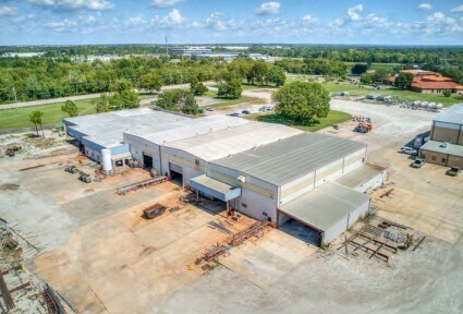
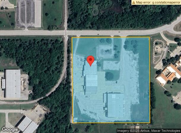
Property Record
5708 E 66Th St N, Tulsa, OK 74117

NEARBY LISTINGS FOR SALE OR LEASE
Property Detail
5708 E 66Th St N
Tulsa, OK
Cherokee Expressway Ind District
61049-03-03-41110
LT 4 LESS BEG 50S & 50W NEC TH S1202.84 W50 S100 E100 S604.64 W1984.14 N369.16 TH ON CRV LF 897.33 E858.15 N914.03 E530 POB BLK 5
Lightindustrial
Tulsa
X
Oklahoma
40143C0231L
4
2025
17.99 AC
2025
Northeast Tulsa
005808
Tulsa
85,489 SF
DEMOGRAPHICS near 5708 E 66Th St N
1 mile
3 mile
5 mile
2024 Total Population
26
5,143
50,721
2029 Population
27
5,428
53,061
Pop Growth 2024-2029
+ 3.85%
+ 5.54%
+ 4.61%
Average Age
37
39
37
2024 Total Households
9
1,832
18,593
HH Growth 2024-2029
0.00%
+ 5.62%
+ 4.63%
Median Household Inc
$137,500
$72,590
$46,999
Avg Household Size
2.90
2.70
2.60
2024 Avg HH Vehicles
3.00
2.00
2.00
Median Home Value
$325,000
$263,778
$135,861
Median Year Built
2011
1998
1974
Nearby Places
Map Layers
Map Styles
 Street
 Aerial
Transit
 Traffic
 Biking
Places
Listings with unknown addresses are not visible on the map
- Restaurants
- Banks
- Shops
- Fitness
- Groceries
PUBLIC TRANSPORTATION
AIRPORT
Tulsa International
Drive
Walk
Distance
Tulsa International
15 min
8.6 mi
Freight Ports
Tulsa Port Of Catoosa
Drive
Walk
Distance
Tulsa Port Of Catoosa
21 min
13.9 mi
SALE & LEASE HISTORY
LISTING DATE
SALE/LEASE

Oct 20, 2025
For Sale
Nearby Properties
Address
Land Use
TOTAL SIZE
Lot Size
Zoning
Address
Land Use
TOTAL SIZE
Lot Size
Zoning
3,235,512 SF
71.56 AC
IM
Address
Land Use
TOTAL SIZE
Lot Size
Zoning
873,896 SF
50 AC
IM
Address
Land Use
TOTAL SIZE
Lot Size
Zoning
209,620 SF
19.59 AC
IM
Address
Land Use
TOTAL SIZE
Lot Size
Zoning
429,912 SF
59.57 AC
IM
Address
Land Use
TOTAL SIZE
Lot Size
Zoning
65,354 SF
41.54 AC
AG
Address
Land Use
TOTAL SIZE
Lot Size
Zoning
63,108 SF
33.82 AC
AG
Address
Land Use
TOTAL SIZE
Lot Size
Zoning
42,665 SF
493.63 AC
RS3
Address
Land Use
TOTAL SIZE
Lot Size
Zoning
457,823 SF
25.72 AC
IM
Address
Land Use
TOTAL SIZE
Lot Size
Zoning
67,909 SF
48.73 AC
IM
Address
Land Use
TOTAL SIZE
Lot Size
Zoning
16,196 SF
9.73 AC
IL
Address
Land Use
TOTAL SIZE
Lot Size
Zoning
36,450 SF
30.52 AC
RS3
Address
Land Use
TOTAL SIZE
Lot Size
Zoning
513.99 AC
RS3
Address
Land Use
TOTAL SIZE
Lot Size
Zoning
859,108 SF
86.24 AC
IM
Address
Land Use
TOTAL SIZE
Lot Size
Zoning
53.24 AC
IM
Address
Land Use
TOTAL SIZE
Lot Size
Zoning
24,679 SF
46.96 AC
IM
Address
Land Use
TOTAL SIZE
Lot Size
Zoning
229,485 SF
16.77 AC
IM
Address
Land Use
TOTAL SIZE
Lot Size
Zoning
32,300 SF
20.88 AC
NCU
Address
Land Use
TOTAL SIZE
Lot Size
Zoning
133,467 SF
11.37 AC
CS
Address
Land Use
TOTAL SIZE
Lot Size
Zoning
5,670 SF
96.05 AC
AG
Address
Land Use
TOTAL SIZE
Lot Size
Zoning
473,599 SF
56.42 AC
IM
Address
Land Use
TOTAL SIZE
Lot Size
Zoning
419,821 SF
38.38 AC
IM
Address
Land Use
TOTAL SIZE
Lot Size
Zoning
29,065 SF
111.30 AC
RS
Address
Land Use
TOTAL SIZE
Lot Size
Zoning
61.50 AC
Address
Land Use
TOTAL SIZE
Lot Size
Zoning
6,800 SF
347.73 AC
RS3
Address
Land Use
TOTAL SIZE
Lot Size
Zoning
9,566 SF
8.26 AC
IL
Address
Land Use
TOTAL SIZE
Lot Size
Zoning
137,320 SF
40.12 AC
IM
Address
Land Use
TOTAL SIZE
Lot Size
Zoning
83,000 SF
10.51 AC
IM
Address
Land Use
TOTAL SIZE
Lot Size
Zoning
175,614 SF
33.58 AC
IM
Address
Land Use
TOTAL SIZE
Lot Size
Zoning
1 SF
228.69 AC
AG
Address
Land Use
TOTAL SIZE
Lot Size
Zoning
224,354 SF
39.13 AC
IM
The World's #1 Commercial Real Estate Marketplace
Connect with us
© 2026 CoStar Group
The information above has been obtained from sources believed reliable. While we do not doubt its accuracy we have not verified it and make no guarantee, warranty or representation about it. It is your responsibility to independently confirm its accuracy and completeness. Any projections, opinions, assumptions, or estimates used are for example only and do not represent the current or future performance of the property. The value of this transaction to you depends on tax and other factors which should be evaluated by your tax, financial, and legal advisors. You and your advisors should conduct a careful, independent investigation of the property to determine to your satisfaction the suitability of the property for your needs.