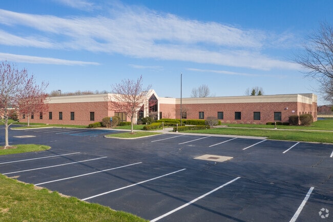
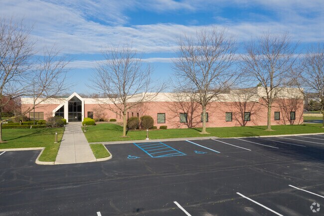
Property Record
571 Longbow Dr, Maumee, OH 43537


Property Detail
571 Longbow Dr
36-41213
ARROWHEAD PLAT 7 LOT 119 S 430 FT W 360 FT(SEE 36-41212 FOR EX
Officebuilding
Lucas
16-CM
Ohio
B and X Area of moderate flood hazard, usually the area between the limits of the 100-year and 500-year floods.
119
0
3.55 AC
2025
South/Southwest
007104
Toledo
22,594 SF
Toledo, OH
NEARBY LISTINGS FOR SALE OR LEASE
DEMOGRAPHICS near 571 Longbow Dr
1 mile
3 mile
5 mile
2025 Total Population
485
47,206
121,130
2030 Population
484
46,557
120,044
Pop Growth 2025-2030
(0.21%)
(1.37%)
(0.90%)
Average Age
46
43
41
2025 Total Households
193
20,683
52,113
HH Growth 2025-2030
(0.52%)
(1.38%)
(0.91%)
Median Household Inc
$112,037
$83,776
$76,388
Avg Household Size
2.30
2.20
2.30
2025 Avg HH Vehicles
2.00
2.00
2.00
Median Home Value
$318,310
$264,365
$249,210
Median Year Built
1983
1978
1978
Nearby Places
Map Layers
Map Styles
 Street
 Aerial
Transit
 Traffic
 Biking
Places
Listings with unknown addresses are not visible on the map
- Restaurants
- Banks
- Shops
- Fitness
- Groceries
PUBLIC TRANSPORTATION
COMMUTER RAIL
Toledo (Capitol Limited - Amtrak, Lake Shore Limited - Amtrak)
Drive
Walk
Distance
Toledo (Capitol Limited - Amtrak, Lake Shore Limited - Amtrak)
15 min
10.0 mi
AIRPORT
Eugene F Kranz Toledo Express
Drive
Walk
Distance
Eugene F Kranz Toledo Express
22 min
9.7 mi
Freight Ports
Port of Toledo
Drive
Walk
Distance
Port of Toledo
28 min
16.1 mi
SALE & LEASE HISTORY
LISTING DATE
SALE/LEASE

Feb 17, 2021
For Lease
Nearby Properties
Address
Land Use
TOTAL SIZE
Lot Size
Zoning
Address
Land Use
TOTAL SIZE
Lot Size
Zoning
541,518 SF
21.30 AC
16-R1
Address
Land Use
TOTAL SIZE
Lot Size
Zoning
275,990 SF
49.65 AC
16-CM
Address
Land Use
TOTAL SIZE
Lot Size
Zoning
67,264 SF
6.95 AC
16-CM
Address
Land Use
TOTAL SIZE
Lot Size
Zoning
186,190 SF
14 AC
19-C2
Address
Land Use
TOTAL SIZE
Lot Size
Zoning
196,149 SF
18.69 AC
10-RD6
Address
Land Use
TOTAL SIZE
Lot Size
Zoning
35.94 AC
17-C3
Address
Land Use
TOTAL SIZE
Lot Size
Zoning
211,140 SF
28.92 AC
10-IC
Address
Land Use
TOTAL SIZE
Lot Size
Zoning
231,756 SF
31.37 AC
16-M1
Address
Land Use
TOTAL SIZE
Lot Size
Zoning
269,263 SF
55.93 AC
16-R2
Address
Land Use
TOTAL SIZE
Lot Size
Zoning
138,607 SF
21.30 AC
10-RS12
Address
Land Use
TOTAL SIZE
Lot Size
Zoning
178,915 SF
13 AC
19-R3
Address
Land Use
TOTAL SIZE
Lot Size
Zoning
606,883 SF
119.87 AC
16-M2
Address
Land Use
TOTAL SIZE
Lot Size
Zoning
352,382 SF
62.93 AC
16-M1
Address
Land Use
TOTAL SIZE
Lot Size
Zoning
337,990 SF
17.75 AC
16-M1
Address
Land Use
TOTAL SIZE
Lot Size
Zoning
8.57 AC
16-M1
Address
Land Use
TOTAL SIZE
Lot Size
Zoning
608,280 SF
48.86 AC
16-M2
Address
Land Use
TOTAL SIZE
Lot Size
Zoning
212,664 SF
21.43 AC
24-B3
Address
Land Use
TOTAL SIZE
Lot Size
Zoning
139,741 SF
30.48 AC
19-RA3
Address
Land Use
TOTAL SIZE
Lot Size
Zoning
203,839 SF
16.39 AC
24-SUP
Address
Land Use
TOTAL SIZE
Lot Size
Zoning
212,672 SF
15.98 AC
17-R1
Address
Land Use
TOTAL SIZE
Lot Size
Zoning
350,408 SF
20.83 AC
17-M2
Address
Land Use
TOTAL SIZE
Lot Size
Zoning
156,420 SF
12 AC
19-R3
Address
Land Use
TOTAL SIZE
Lot Size
Zoning
238,148 SF
18.20 AC
24-B3
Address
Land Use
TOTAL SIZE
Lot Size
Zoning
214,986 SF
17.55 AC
19-R1
Address
Land Use
TOTAL SIZE
Lot Size
Zoning
119.87 AC
16-M2
Address
Land Use
TOTAL SIZE
Lot Size
Zoning
111,195 SF
13.64 AC
19-C2
Address
Land Use
TOTAL SIZE
Lot Size
Zoning
78,166 SF
2.08 AC
16-CM
Address
Land Use
TOTAL SIZE
Lot Size
Zoning
120,077 SF
9.53 AC
24-B3
Address
Land Use
TOTAL SIZE
Lot Size
Zoning
104,314 SF
15.43 AC
16-M2
Address
Land Use
TOTAL SIZE
Lot Size
Zoning
32.75 AC
16-M2
The World's #1 Commercial Real Estate Marketplace
Connect with us
© 2026 CoStar Group
The information above has been obtained from sources believed reliable. While we do not doubt its accuracy we have not verified it and make no guarantee, warranty or representation about it. It is your responsibility to independently confirm its accuracy and completeness. Any projections, opinions, assumptions, or estimates used are for example only and do not represent the current or future performance of the property. The value of this transaction to you depends on tax and other factors which should be evaluated by your tax, financial, and legal advisors. You and your advisors should conduct a careful, independent investigation of the property to determine to your satisfaction the suitability of the property for your needs.