Property Record
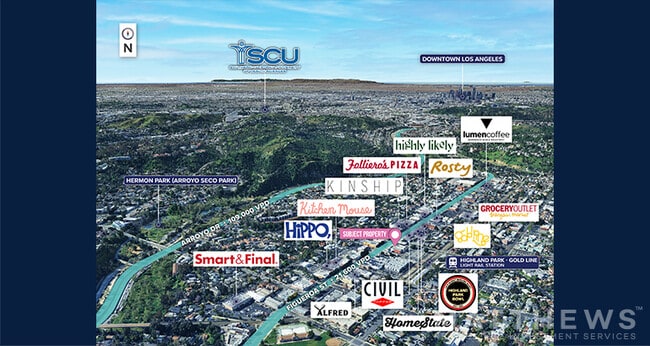
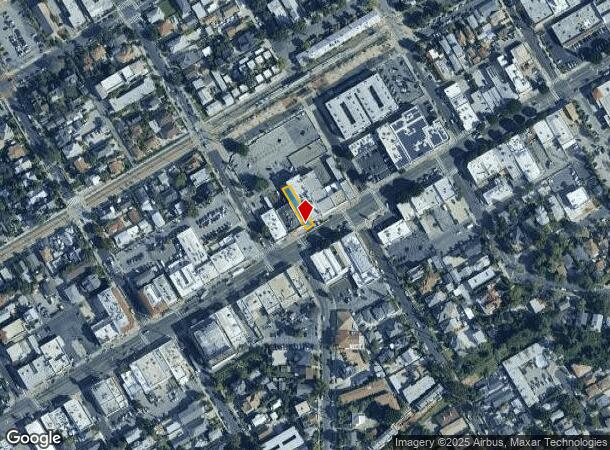
5711 N Figueroa St, Los Angeles, CA 90042
Current Lease Availabilities
NEARBY LISTINGS FOR SALE OR LEASE
-
-
-
-
-
-
-
-
-
No Photo
-
-
-
-
-
-
-
-
-
-
-
-
-
-
-
-
-
-
-
View all Los Angeles listings for lease on LoopNet.com
Property Detail
5711 N Figueroa St
Los Angeles-Long Beach-Glendale, CA
Highland Park
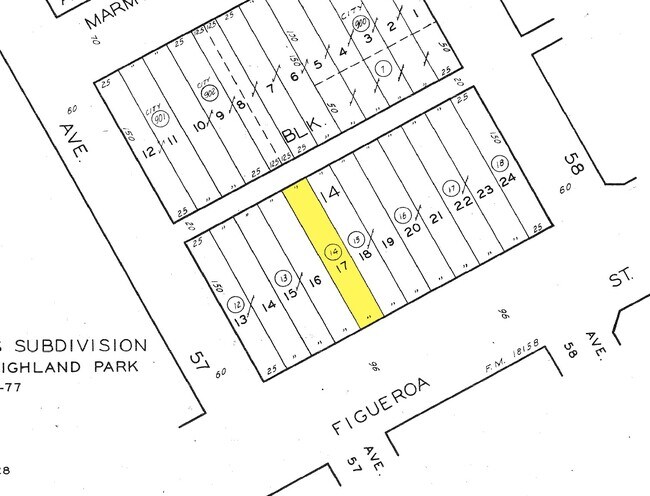
5492-001-014
RALPH ROGERS SUB OF BLK 14 HIGHLAND PARK LOT 17
Storemultistory
Los Angeles
X
California
06037C1627F
17
2024
0.09 AC
2025
Glendale
183610
Los Angeles
2,225 SF
DEMOGRAPHICS near 5711 N Figueroa St
1 Mile
3 Mile
5 Mile
2024 Total Population
38,434
231,448
682,340
2029 Population
36,937
223,530
659,676
Pop Growth 2024-2029
(3.89%)
(3.42%)
(3.32%)
Average Age
39
41
41
2024 Total Households
13,869
81,210
249,907
HH Growth 2024-2029
(4.12%)
(3.67%)
(3.53%)
Median Household Inc
$84,389
$89,749
$78,925
Avg Household Size
2.70
2.70
2.60
2024 Avg HH Vehicles
2.00
2.00
2.00
Median Home Value
$800,891
$882,571
$874,087
Median Year Built
1954
1952
1958
Nearby Places
Map Layers
Map Styles
 Street
 Aerial
- Restaurants
- Banks
- Shops
- Fitness
- Groceries
PUBLIC TRANSPORTATION
COMMUTER RAIL
DRIVE
WALK
Distance
10 min
5.2 mi
Union Station (91 Line - Southern California Regional Rail Authority (Metrolink), Antelope Valley Line - Southern California Regional Rail Authority (Metrolink), Orange County Line - Southern California Regional Rail Authority (Metrolink), Riverside Line - Southern California Regional Rail Authority (Metrolink), San Bernardino Line - Southern California Regional Rail Authority (Metrolink), Ventura County Line - Southern California Regional Rail Authority (Metrolink))
DRIVE
WALK
Distance
Union Station (91 Line - Southern California Regional Rail Authority (Metrolink), Antelope Valley Line - Southern California Regional Rail Authority (Metrolink), Orange County Line - Southern California Regional Rail Authority (Metrolink), Riverside Line - Southern California Regional Rail Authority (Metrolink), San Bernardino Line - Southern California Regional Rail Authority (Metrolink), Ventura County Line - Southern California Regional Rail Authority (Metrolink))
11 min
5.3 mi
AIRPORT
Bob Hope
DRIVE
WALK
Distance
Bob Hope
24 min
17.3 mi
Los Angeles International
DRIVE
WALK
Distance
Los Angeles International
32 min
20.3 mi
Long Beach (Daugherty Field)
DRIVE
WALK
Distance
Long Beach (Daugherty Field)
38 min
25.7 mi
Freight Ports
Port of Long Beach
DRIVE
WALK
Distance
Port of Long Beach
40 min
28.5 mi
Nearby Properties
Address
Land Use
TOTAL SIZE
Lot Size
Zoning
Address
Land Use
TOTAL SIZE
Lot Size
Zoning
874,871 SF
25.01 AC
PSC*
Address
Land Use
TOTAL SIZE
Lot Size
Zoning
534,225 SF
Address
Land Use
TOTAL SIZE
Lot Size
Zoning
251,317 SF
114.56 AC
LAR1
Address
Land Use
TOTAL SIZE
Lot Size
Zoning
372,451 SF
3.24 AC
PSC*
Address
Land Use
TOTAL SIZE
Lot Size
Zoning
119,455 SF
5.04 AC
LACM
Address
Land Use
TOTAL SIZE
Lot Size
Zoning
53,760 SF
4.60 AC
LAM1
Address
Land Use
TOTAL SIZE
Lot Size
Zoning
1,119,154 SF
LAC4
Address
Land Use
TOTAL SIZE
Lot Size
Zoning
130,553 SF
1.93 AC
PSR*
Address
Land Use
TOTAL SIZE
Lot Size
Zoning
75,577 SF
1.92 AC
PSC-
Address
Land Use
TOTAL SIZE
Lot Size
Zoning
118,320 SF
8.01 AC
LAM2
Address
Land Use
TOTAL SIZE
Lot Size
Zoning
63,406 SF
5 AC
LAC4
Address
Land Use
TOTAL SIZE
Lot Size
Zoning
188,634 SF
1.07 AC
LAUI(CA)
Address
Land Use
TOTAL SIZE
Lot Size
Zoning
87,236 SF
2.62 AC
SPP*
Address
Land Use
TOTAL SIZE
Lot Size
Zoning
165,246 SF
1.10 AC
PSR*
Address
Land Use
TOTAL SIZE
Lot Size
Zoning
131,209 SF
1.51 AC
PSC-
Address
Land Use
TOTAL SIZE
Lot Size
Zoning
23.44 AC
LAM2
Address
Land Use
TOTAL SIZE
Lot Size
Zoning
146,264 SF
1.87 AC
LAMR1
Address
Land Use
TOTAL SIZE
Lot Size
Zoning
64,497 SF
0.80 AC
LAC2
Address
Land Use
TOTAL SIZE
Lot Size
Zoning
155,339 SF
3.99 AC
LAMR1
Address
Land Use
TOTAL SIZE
Lot Size
Zoning
92,530 SF
3.16 AC
LARD1.5
Address
Land Use
TOTAL SIZE
Lot Size
Zoning
180,384 SF
2.03 AC
PSC*
Address
Land Use
TOTAL SIZE
Lot Size
Zoning
182,254 SF
2.14 AC
LAUV(CA)
Address
Land Use
TOTAL SIZE
Lot Size
Zoning
121,733 SF
5.59 AC
ALMPD*
Address
Land Use
TOTAL SIZE
Lot Size
Zoning
45,327 SF
9.50 AC
PSP*
Address
Land Use
TOTAL SIZE
Lot Size
Zoning
355,944 SF
7.48 AC
LAM1
Address
Land Use
TOTAL SIZE
Lot Size
Zoning
87,980 SF
3.62 AC
LACM
Address
Land Use
TOTAL SIZE
Lot Size
Zoning
107,880 SF
7.95 AC
LAUC(CA)
Address
Land Use
TOTAL SIZE
Lot Size
Zoning
96,575 SF
9.18 AC
LAMR1
Address
Land Use
TOTAL SIZE
Lot Size
Zoning
322,596 SF
5.65 AC
ALMPD*
Address
Land Use
TOTAL SIZE
Lot Size
Zoning
52,153 SF
0.40 AC
LAUV(CA)
The World's #1 Commercial Real Estate Marketplace
Connect with us
© 2025 CoStar Group
The information above has been obtained from sources believed reliable. While we do not doubt its accuracy we have not verified it and make no guarantee, warranty or representation about it. It is your responsibility to independently confirm its accuracy and completeness. Any projections, opinions, assumptions, or estimates used are for example only and do not represent the current or future performance of the property. The value of this transaction to you depends on tax and other factors which should be evaluated by your tax, financial, and legal advisors. You and your advisors should conduct a careful, independent investigation of the property to determine to your satisfaction the suitability of the property for your needs.