Property Record
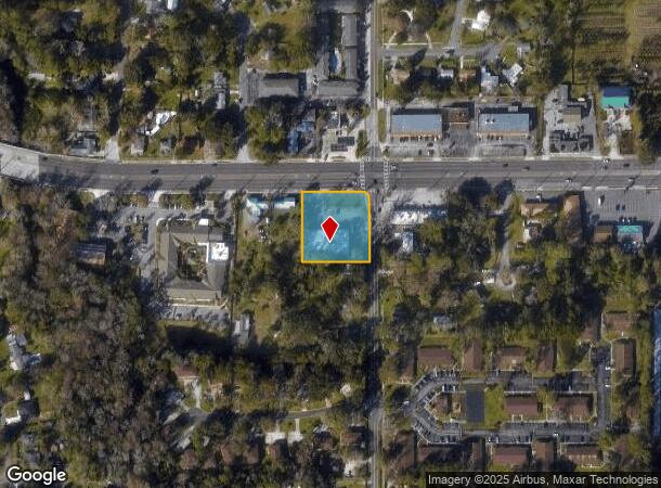
5506 Seaboard Ave, Jacksonville, FL 32244
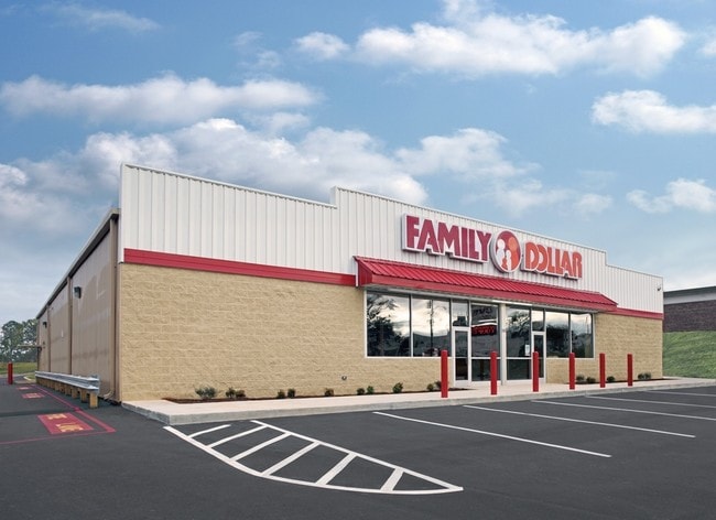

This Property Is For Sale
NEARBY LISTINGS FOR SALE OR LEASE
Property Detail
5506 Seaboard Ave
Jacksonville, FL
Seaboard Homes R/P Pt Ort
103751-0100
19-49 18-3S-26E .928 SEABOARD HOMES R/P PT ORTEGA FARMS LOTS 3, 4 (EX PT IN ST RD) BLK 1
Storebuilding
Duval
X
Florida
12031C0526J
3,4
2024
1.04 AC
2025
Riverside
013526
Jacksonville (Florida)
9,374 SF
DEMOGRAPHICS near 5506 Seaboard Ave
1 Mile
3 Mile
5 Mile
2024 Total Population
9,996
74,309
175,629
2029 Population
10,595
77,968
184,768
Pop Growth 2024-2029
+ 5.99%
+ 4.92%
+ 5.20%
Average Age
40
38
38
2024 Total Households
4,141
29,223
70,388
HH Growth 2024-2029
+ 6.16%
+ 5.06%
+ 5.34%
Median Household Inc
$48,035
$53,019
$54,616
Avg Household Size
2.30
2.50
2.40
2024 Avg HH Vehicles
2.00
2.00
2.00
Median Home Value
$187,988
$185,902
$193,492
Median Year Built
1977
1975
1978
Nearby Places
Map Layers
Map Styles
 Street
 Aerial
- Restaurants
- Banks
- Shops
- Fitness
- Groceries
PUBLIC TRANSPORTATION
AIRPORT
Jacksonville International
DRIVE
WALK
Distance
Jacksonville International
34 min
23.5 mi
Freight Ports
Jacksonville Port
DRIVE
WALK
Distance
Jacksonville Port
24 min
13.6 mi
Nearby Properties
Address
Land Use
TOTAL SIZE
Lot Size
Zoning
Address
Land Use
TOTAL SIZE
Lot Size
Zoning
402,240 SF
20.66 AC
PUD
Address
Land Use
TOTAL SIZE
Lot Size
Zoning
184,092 SF
21.69 AC
CCG-1
Address
Land Use
TOTAL SIZE
Lot Size
Zoning
179,916 SF
12.19 AC
RMD-D
Address
Land Use
TOTAL SIZE
Lot Size
Zoning
416,674 SF
18.38 AC
RMD-D
Address
Land Use
TOTAL SIZE
Lot Size
Zoning
309,461 SF
20.09 AC
RMD-D
Address
Land Use
TOTAL SIZE
Lot Size
Zoning
203,724 SF
14.71 AC
RMD-D
Address
Land Use
TOTAL SIZE
Lot Size
Zoning
220,288 SF
13.51 AC
RMD-D
Address
Land Use
TOTAL SIZE
Lot Size
Zoning
109,253 SF
21.68 AC
CCG-2
Address
Land Use
TOTAL SIZE
Lot Size
Zoning
228,290 SF
12.65 AC
RMD-D
Address
Land Use
TOTAL SIZE
Lot Size
Zoning
188,578 SF
13.44 AC
RMD-D
Address
Land Use
TOTAL SIZE
Lot Size
Zoning
376,882 SF
54.84 AC
PUD
Address
Land Use
TOTAL SIZE
Lot Size
Zoning
277,225 SF
11.72 AC
RMD-D
Address
Land Use
TOTAL SIZE
Lot Size
Zoning
137,636 SF
9.73 AC
RMD-D
Address
Land Use
TOTAL SIZE
Lot Size
Zoning
96,314 SF
21.05 AC
CCG-1
Address
Land Use
TOTAL SIZE
Lot Size
Zoning
230,837 SF
10.94 AC
RMD-D
Address
Land Use
TOTAL SIZE
Lot Size
Zoning
206,513 SF
9.83 AC
RMD-D
Address
Land Use
TOTAL SIZE
Lot Size
Zoning
171,412 SF
16.44 AC
RMD-D
Address
Land Use
TOTAL SIZE
Lot Size
Zoning
229,441 SF
17.48 AC
PUD
Address
Land Use
TOTAL SIZE
Lot Size
Zoning
67,581 SF
24.24 AC
PUD
Address
Land Use
TOTAL SIZE
Lot Size
Zoning
152,768 SF
9.66 AC
RMD-D
Address
Land Use
TOTAL SIZE
Lot Size
Zoning
159,337 SF
11.09 AC
RMD-D
Address
Land Use
TOTAL SIZE
Lot Size
Zoning
169,084 SF
13 AC
CCG-1
Address
Land Use
TOTAL SIZE
Lot Size
Zoning
187,612 SF
20.16 AC
PUD
Address
Land Use
TOTAL SIZE
Lot Size
Zoning
103,833 SF
19.32 AC
PUD
Address
Land Use
TOTAL SIZE
Lot Size
Zoning
57,762 SF
11.90 AC
CCG-2
Address
Land Use
TOTAL SIZE
Lot Size
Zoning
136,029 SF
4.96 AC
RMD-D
Address
Land Use
TOTAL SIZE
Lot Size
Zoning
160,634 SF
16.36 AC
RMD-D
Address
Land Use
TOTAL SIZE
Lot Size
Zoning
73,769 SF
8.87 AC
CCG-1
Address
Land Use
TOTAL SIZE
Lot Size
Zoning
85,238 SF
3.90 AC
CCG-2
Address
Land Use
TOTAL SIZE
Lot Size
Zoning
107,045 SF
9 AC
RMD-D
The World's #1 Commercial Real Estate Marketplace
Connect with us
© 2025 CoStar Group
The information above has been obtained from sources believed reliable. While we do not doubt its accuracy we have not verified it and make no guarantee, warranty or representation about it. It is your responsibility to independently confirm its accuracy and completeness. Any projections, opinions, assumptions, or estimates used are for example only and do not represent the current or future performance of the property. The value of this transaction to you depends on tax and other factors which should be evaluated by your tax, financial, and legal advisors. You and your advisors should conduct a careful, independent investigation of the property to determine to your satisfaction the suitability of the property for your needs.