Property Record
5715 34Th Ave, Gig Harbor, WA 98335

NEARBY LISTINGS FOR SALE OR LEASE
-
-
View all Gig Harbor listings for sale on LoopNet.com
Property Detail
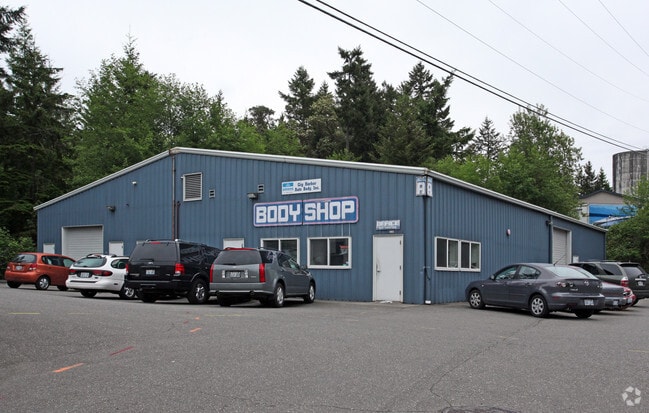
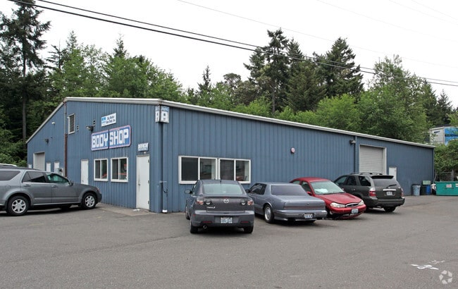
5715 34Th Ave
Seattle-Tacoma-Bellevue, WA
Pierce County Short Plat 9708150427
022117-6022
SECTION 17 TOWNSHIP 21 RANGE 02 QUARTER 24 : L 3 OF SP 97-08-15-0427 AMEND OF SP 83-10-21-0291 TOG/W EASE & RESTRICTIONS OF REC OUT OF 2-044 &2-045 SEG T-1318 SG ES (DC 4-5-96 CK) DC10/10/97CL DC/BL 10-25-06BL 4277685DC 3/29/19 KG
Autorepair
Pierce
X
Washington
53033C1200G
3
2024
1.04 AC
2025
Gig Harbor/W Pierce
072407
Seattle/Puget Sound
2,808 SF
DEMOGRAPHICS near 5715 34Th Ave
1 Mile
3 Mile
5 Mile
2024 Total Population
7,467
27,274
82,629
2029 Population
7,776
28,261
85,608
Pop Growth 2024-2029
+ 4.14%
+ 3.62%
+ 3.61%
Average Age
46
46
45
2024 Total Households
3,155
11,025
34,372
HH Growth 2024-2029
+ 4.09%
+ 3.63%
+ 3.74%
Median Household Inc
$109,117
$119,182
$111,717
Avg Household Size
2.30
2.40
2.30
2024 Avg HH Vehicles
2.00
2.00
2.00
Median Home Value
$682,922
$710,154
$686,433
Median Year Built
1988
1989
1983
Nearby Places
- Restaurants
- Banks
- Shops
- Fitness
- Groceries
PUBLIC TRANSPORTATION
AIRPORT
Seattle-Tacoma International
DRIVE
WALK
Distance
Seattle-Tacoma International
47 min
31.6 mi
Freight Ports
Port of Tacoma
DRIVE
WALK
Distance
Port of Tacoma
19 min
13.2 mi
Nearby Properties
Address
Land Use
TOTAL SIZE
Lot Size
Zoning
Address
Land Use
TOTAL SIZE
Lot Size
Zoning
189,797 SF
18.06 AC
RB-2
Address
Land Use
TOTAL SIZE
Lot Size
Zoning
318,450 SF
36.63 AC
ED
Address
Land Use
TOTAL SIZE
Lot Size
Zoning
132,295 SF
100.76 AC
UML
Address
Land Use
TOTAL SIZE
Lot Size
Zoning
184,782 SF
23.38 AC
B-2
Address
Land Use
TOTAL SIZE
Lot Size
Zoning
228,761 SF
4 AC
R10
Address
Land Use
TOTAL SIZE
Lot Size
Zoning
321,717 SF
75.30 AC
PI
Address
Land Use
TOTAL SIZE
Lot Size
Zoning
297,754 SF
59.70 AC
PI
Address
Land Use
TOTAL SIZE
Lot Size
Zoning
166,830 SF
7.36 AC
Address
Land Use
TOTAL SIZE
Lot Size
Zoning
91,277 SF
5.08 AC
GIGH
Address
Land Use
TOTAL SIZE
Lot Size
Zoning
115,222 SF
27.53 AC
Address
Land Use
TOTAL SIZE
Lot Size
Zoning
123,138 SF
14.89 AC
RB-2
Address
Land Use
TOTAL SIZE
Lot Size
Zoning
106,293 SF
7.60 AC
Address
Land Use
TOTAL SIZE
Lot Size
Zoning
117,424 SF
24.84 AC
R-1
Address
Land Use
TOTAL SIZE
Lot Size
Zoning
129,455 SF
9.44 AC
RB-2
Address
Land Use
TOTAL SIZE
Lot Size
Zoning
110,156 SF
9.54 AC
B-2
Address
Land Use
TOTAL SIZE
Lot Size
Zoning
104,043 SF
1.92 AC
B-2
Address
Land Use
TOTAL SIZE
Lot Size
Zoning
114,306 SF
6.54 AC
R-3
Address
Land Use
TOTAL SIZE
Lot Size
Zoning
83,169 SF
6.66 AC
B-2
Address
Land Use
TOTAL SIZE
Lot Size
Zoning
149,856 SF
19.34 AC
R2
Address
Land Use
TOTAL SIZE
Lot Size
Zoning
116,103 SF
4.14 AC
R10
Address
Land Use
TOTAL SIZE
Lot Size
Zoning
132,257 SF
359.08 AC
EFRAS
Address
Land Use
TOTAL SIZE
Lot Size
Zoning
62,960 SF
5.41 AC
C-1
Address
Land Use
TOTAL SIZE
Lot Size
Zoning
77,350 SF
9.07 AC
R10
Address
Land Use
TOTAL SIZE
Lot Size
Zoning
77,906 SF
5 AC
R-1
Address
Land Use
TOTAL SIZE
Lot Size
Zoning
78,124 SF
4.65 AC
R-3
Address
Land Use
TOTAL SIZE
Lot Size
Zoning
80,000 SF
9.17 AC
R10
Address
Land Use
TOTAL SIZE
Lot Size
Zoning
105,563 SF
5.09 AC
B-2
Address
Land Use
TOTAL SIZE
Lot Size
Zoning
63,700 SF
4.73 AC
B-2
Address
Land Use
TOTAL SIZE
Lot Size
Zoning
76,925 SF
11.63 AC
PI
Address
Land Use
TOTAL SIZE
Lot Size
Zoning
57,801 SF
5.42 AC
B-2
The World's #1 Commercial Real Estate Marketplace
Connect with us
© 2025 CoStar Group
The information above has been obtained from sources believed reliable. While we do not doubt its accuracy we have not verified it and make no guarantee, warranty or representation about it. It is your responsibility to independently confirm its accuracy and completeness. Any projections, opinions, assumptions, or estimates used are for example only and do not represent the current or future performance of the property. The value of this transaction to you depends on tax and other factors which should be evaluated by your tax, financial, and legal advisors. You and your advisors should conduct a careful, independent investigation of the property to determine to your satisfaction the suitability of the property for your needs.