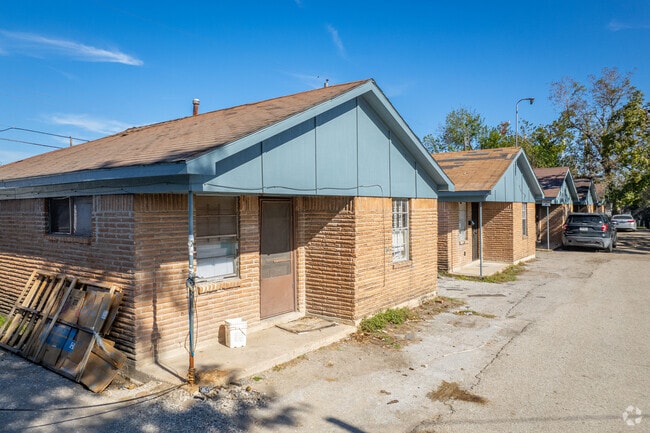
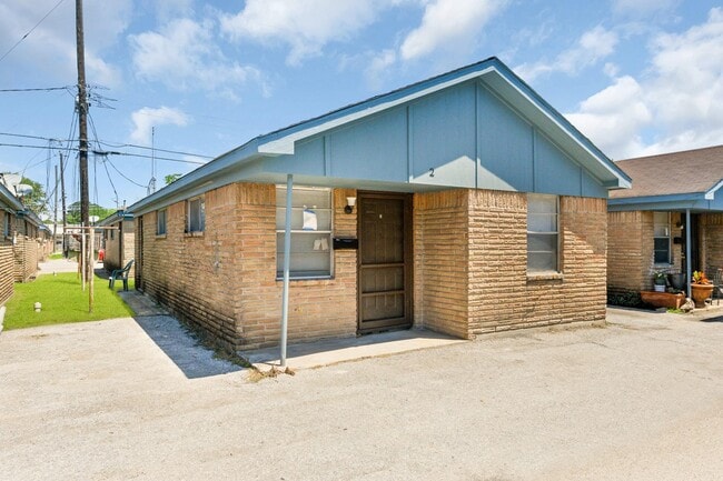
Property Record
5716 Pickfair St, Houston, TX 77026

NEARBY LISTINGS FOR SALE OR LEASE
Property Detail
5716 Pickfair St
Houston-Pasadena-The Woodlands, TX
Ashwood At 610 Condo
0651290720680
UNIT 7 .0227 INT COMMON LAND & ELE ASHWOOD AT 610 CONDO
Condominium
Harris
AE
Texas
48201C0690N
1680
2024
0.34 AC
2025
Trinity-Houston Gardens
230200
Houston
779 SF
DEMOGRAPHICS near 5716 Pickfair St
1 mile
3 mile
5 mile
2024 Total Population
10,252
105,081
295,533
2029 Population
10,711
108,800
305,259
Pop Growth 2024-2029
+ 4.48%
+ 3.54%
+ 3.29%
Average Age
37
37
37
2024 Total Households
3,735
36,245
104,476
HH Growth 2024-2029
+ 4.47%
+ 3.54%
+ 3.65%
Median Household Inc
$33,554
$33,651
$44,418
Avg Household Size
2.70
2.80
2.70
2024 Avg HH Vehicles
1.00
2.00
2.00
Median Home Value
$93,875
$119,809
$173,698
Median Year Built
1963
1960
1963
Nearby Places
Map Layers
Map Styles
 Street
 Aerial
Transit
 Traffic
 Biking
Places
Listings with unknown addresses are not visible on the map
- Restaurants
- Banks
- Shops
- Fitness
- Groceries
PUBLIC TRANSPORTATION
COMMUTER RAIL
Houston (Sunset Limited - Amtrak)
Drive
Walk
Distance
Houston (Sunset Limited - Amtrak)
12 min
6.4 mi
AIRPORT
George Bush Intcntl/Houston
Drive
Walk
Distance
George Bush Intcntl/Houston
22 min
16.1 mi
William P Hobby
Drive
Walk
Distance
William P Hobby
29 min
16.8 mi
Freight Ports
Port of Houston
Drive
Walk
Distance
Port of Houston
15 min
8.8 mi
SALE & LEASE HISTORY
LISTING DATE
SALE/LEASE

Nov 30, 2023
For Sale
Mar 17, 2025
For Sale
Mar 14, 2025
For Sale
Mar 14, 2025
For Sale
Nearby Properties
Address
Land Use
TOTAL SIZE
Lot Size
Zoning
Address
Land Use
TOTAL SIZE
Lot Size
Zoning
12,206,592 SF
212.18 AC
Address
Land Use
TOTAL SIZE
Lot Size
Zoning
663,147 SF
40.63 AC
Address
Land Use
TOTAL SIZE
Lot Size
Zoning
Address
Land Use
TOTAL SIZE
Lot Size
Zoning
433,639 SF
19.89 AC
Address
Land Use
TOTAL SIZE
Lot Size
Zoning
304,925 SF
10.91 AC
Address
Land Use
TOTAL SIZE
Lot Size
Zoning
254,904 SF
9.27 AC
Address
Land Use
TOTAL SIZE
Lot Size
Zoning
177,720 SF
14.96 AC
Address
Land Use
TOTAL SIZE
Lot Size
Zoning
229,050 SF
8.13 AC
Address
Land Use
TOTAL SIZE
Lot Size
Zoning
306,886 SF
45.06 AC
Address
Land Use
TOTAL SIZE
Lot Size
Zoning
234,016 SF
7.75 AC
Address
Land Use
TOTAL SIZE
Lot Size
Zoning
205,000 SF
9.49 AC
Address
Land Use
TOTAL SIZE
Lot Size
Zoning
219,230 SF
9.92 AC
Address
Land Use
TOTAL SIZE
Lot Size
Zoning
189,018 SF
17 AC
Address
Land Use
TOTAL SIZE
Lot Size
Zoning
196,666 SF
9.38 AC
Address
Land Use
TOTAL SIZE
Lot Size
Zoning
191,567 SF
7.06 AC
Address
Land Use
TOTAL SIZE
Lot Size
Zoning
55,517 SF
13 AC
Address
Land Use
TOTAL SIZE
Lot Size
Zoning
107,450 SF
12.14 AC
Address
Land Use
TOTAL SIZE
Lot Size
Zoning
241,435 SF
13.47 AC
Address
Land Use
TOTAL SIZE
Lot Size
Zoning
108,783 SF
8.83 AC
Address
Land Use
TOTAL SIZE
Lot Size
Zoning
385,950 SF
28.31 AC
Address
Land Use
TOTAL SIZE
Lot Size
Zoning
168,525 SF
6.06 AC
Address
Land Use
TOTAL SIZE
Lot Size
Zoning
186,629 SF
9.75 AC
Address
Land Use
TOTAL SIZE
Lot Size
Zoning
212.26 AC
Address
Land Use
TOTAL SIZE
Lot Size
Zoning
622,385 SF
6.68 AC
Address
Land Use
TOTAL SIZE
Lot Size
Zoning
197,976 SF
24.32 AC
Address
Land Use
TOTAL SIZE
Lot Size
Zoning
67,380 SF
1.81 AC
Address
Land Use
TOTAL SIZE
Lot Size
Zoning
66,452 SF
6 AC
Address
Land Use
TOTAL SIZE
Lot Size
Zoning
129,204 SF
7.03 AC
Address
Land Use
TOTAL SIZE
Lot Size
Zoning
122,305 SF
16.08 AC
Address
Land Use
TOTAL SIZE
Lot Size
Zoning
65,347 SF
8.45 AC
The World's #1 Commercial Real Estate Marketplace
Connect with us
© 2026 CoStar Group
The information above has been obtained from sources believed reliable. While we do not doubt its accuracy we have not verified it and make no guarantee, warranty or representation about it. It is your responsibility to independently confirm its accuracy and completeness. Any projections, opinions, assumptions, or estimates used are for example only and do not represent the current or future performance of the property. The value of this transaction to you depends on tax and other factors which should be evaluated by your tax, financial, and legal advisors. You and your advisors should conduct a careful, independent investigation of the property to determine to your satisfaction the suitability of the property for your needs.