Property Record
5718 W 3500 S, West Valley City, UT 84128
NEARBY LISTINGS FOR SALE OR LEASE
Property Detail
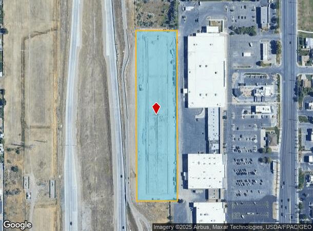
5718 W 3500 S
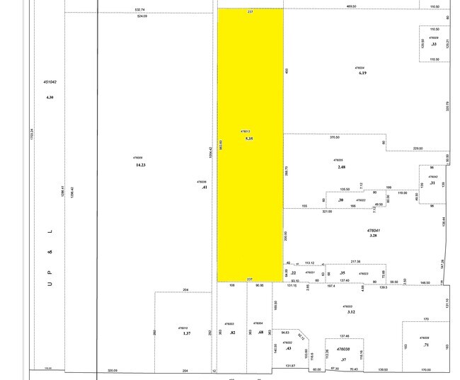
14-26-476-013-0000
Mountain View Business Plaza
Multipleuses
BEG N 0^0950 W 1346.6 FT & S 89^5910 W 653 FT FR SE COR OF SEC 26, T 1S, R 2W, S L M; S 89^5910 W 237 FT; S 0^09 50 E 983.6 FT; N 89^5847 E 237 FT; N 0^0950 W 983.6 FT TO BEG. 5.35 AC M OR L. 5478-2424 5612-0436 5768-1416 6566-2238 7346-1408 10269-61
X
Salt Lake
49035C0275G
Utah
2024
5.35 AC
2025
West Valley/Lake Park
113414
Salt Lake City
103,056 SF
Salt Lake City, UT
DEMOGRAPHICS near 5718 W 3500 S
1 Mile
3 Mile
5 Mile
2024 Total Population
16,617
105,822
231,096
2029 Population
16,681
106,314
233,273
Pop Growth 2024-2029
+ 0.39%
+ 0.46%
+ 0.94%
Average Age
35
35
35
2024 Total Households
4,497
29,042
66,788
HH Growth 2024-2029
+ 0.27%
+ 0.34%
+ 0.91%
Median Household Inc
$86,300
$80,254
$76,213
Avg Household Size
3.60
3.50
3.30
2024 Avg HH Vehicles
3.00
2.00
2.00
Median Home Value
$359,470
$341,699
$334,731
Median Year Built
1991
1979
1982
Nearby Places
- Restaurants
- Banks
- Shops
- Fitness
- Groceries
PUBLIC TRANSPORTATION
AIRPORT
Salt Lake City International
DRIVE
WALK
Distance
Salt Lake City International
13 min
8.3 mi
Freight Ports
Port of Stockton
DRIVE
WALK
Distance
Port of Stockton
708 min
690.8 mi
Nearby Properties
Address
Land Use
TOTAL SIZE
Lot Size
Zoning
Address
Land Use
TOTAL SIZE
Lot Size
Zoning
906,418 SF
46.97 AC
IP-M-1
Address
Land Use
TOTAL SIZE
Lot Size
Zoning
329,306 SF
14.67 AC
5005
Address
Land Use
TOTAL SIZE
Lot Size
Zoning
690,542 SF
35.75 AC
M-1
Address
Land Use
TOTAL SIZE
Lot Size
Zoning
432,730 SF
13.03 AC
R-M
Address
Land Use
TOTAL SIZE
Lot Size
Zoning
634,402 SF
32.29 AC
IP-M
Address
Land Use
TOTAL SIZE
Lot Size
Zoning
505,079 SF
30.07 AC
M-1
Address
Land Use
TOTAL SIZE
Lot Size
Zoning
529,870 SF
13.35 AC
R-M
Address
Land Use
TOTAL SIZE
Lot Size
Zoning
482,870 SF
31.13 AC
M-1
Address
Land Use
TOTAL SIZE
Lot Size
Zoning
475,592 SF
24.09 AC
M-1
Address
Land Use
TOTAL SIZE
Lot Size
Zoning
505,079 SF
25.87 AC
M-1
Address
Land Use
TOTAL SIZE
Lot Size
Zoning
832,383 SF
19.61 AC
IP-M
Address
Land Use
TOTAL SIZE
Lot Size
Zoning
491,507 SF
28.48 AC
M-1
Address
Land Use
TOTAL SIZE
Lot Size
Zoning
289,725 SF
8.42 AC
1108
Address
Land Use
TOTAL SIZE
Lot Size
Zoning
491,507 SF
28.28 AC
M-1
Address
Land Use
TOTAL SIZE
Lot Size
Zoning
480,159 SF
56.52 AC
M-1
Address
Land Use
TOTAL SIZE
Lot Size
Zoning
482,768 SF
22.90 AC
M-1
Address
Land Use
TOTAL SIZE
Lot Size
Zoning
387,633 SF
24 AC
M-1
Address
Land Use
TOTAL SIZE
Lot Size
Zoning
404,800 SF
24.62 AC
M
Address
Land Use
TOTAL SIZE
Lot Size
Zoning
348,300 SF
18.50 AC
M-1
Address
Land Use
TOTAL SIZE
Lot Size
Zoning
496,431 SF
23.89 AC
IP-M
Address
Land Use
TOTAL SIZE
Lot Size
Zoning
449,868 SF
22.27 AC
M
Address
Land Use
TOTAL SIZE
Lot Size
Zoning
229,578 SF
27.42 AC
M--1
Address
Land Use
TOTAL SIZE
Lot Size
Zoning
198,063 SF
12.90 AC
M
Address
Land Use
TOTAL SIZE
Lot Size
Zoning
418,984 SF
21.65 AC
IP-M
Address
Land Use
TOTAL SIZE
Lot Size
Zoning
297,972 SF
45.67 AC
M
Address
Land Use
TOTAL SIZE
Lot Size
Zoning
159,381 SF
18.82 AC
1106
Address
Land Use
TOTAL SIZE
Lot Size
Zoning
131,500 SF
75.92 AC
R-1-10
Address
Land Use
TOTAL SIZE
Lot Size
Zoning
307,935 SF
17.90 AC
M
Address
Land Use
TOTAL SIZE
Lot Size
Zoning
374,120 SF
22.16 AC
IP-M
Address
Land Use
TOTAL SIZE
Lot Size
Zoning
74,439 SF
27.33 AC
M
The World's #1 Commercial Real Estate Marketplace
Connect with us
© 2025 CoStar Group
The information above has been obtained from sources believed reliable. While we do not doubt its accuracy we have not verified it and make no guarantee, warranty or representation about it. It is your responsibility to independently confirm its accuracy and completeness. Any projections, opinions, assumptions, or estimates used are for example only and do not represent the current or future performance of the property. The value of this transaction to you depends on tax and other factors which should be evaluated by your tax, financial, and legal advisors. You and your advisors should conduct a careful, independent investigation of the property to determine to your satisfaction the suitability of the property for your needs.