Property Record
572 Route 6, Mahopac, NY 10541

Current Lease Availabilities
NEARBY LISTINGS FOR SALE OR LEASE
Property Detail
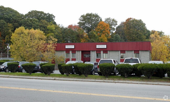
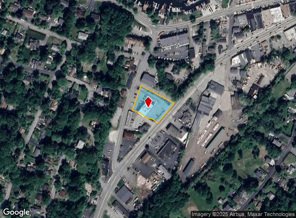
572 Route 6
372000-075-044-0001-054-000-0000
Resubdivision Plat Of A Portion
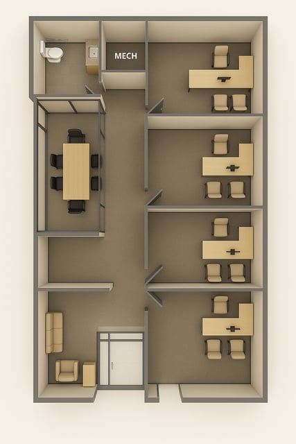
Commercialbuilding
Putnam
X
New York
36079C0226E
54.00
2024
0.68 AC
2024
Carmel
011202
Westchester/So Connecticut
9,926 SF
Dutchess County-Putnam County, NY
DEMOGRAPHICS near 572 Route 6
1 Mile
3 Mile
5 Mile
2024 Total Population
4,781
30,335
60,409
2029 Population
4,776
30,203
59,961
Pop Growth 2024-2029
(0.10%)
(0.44%)
(0.74%)
Average Age
43
44
45
2024 Total Households
1,830
11,242
22,752
HH Growth 2024-2029
(0.11%)
(0.36%)
(0.82%)
Median Household Inc
$99,573
$114,420
$120,784
Avg Household Size
2.50
2.70
2.60
2024 Avg HH Vehicles
2.00
2.00
2.00
Median Home Value
$398,997
$436,810
$459,636
Median Year Built
1963
1971
1973
Nearby Places
Map Layers
Map Styles
 Street
 Aerial
- Restaurants
- Banks
- Shops
- Fitness
- Groceries
PUBLIC TRANSPORTATION
COMMUTER RAIL
Croton Falls Station (Harlem Line - Metro-North Commuter Railroad Company (Metro-North))
DRIVE
WALK
Distance
Croton Falls Station (Harlem Line - Metro-North Commuter Railroad Company (Metro-North))
12 min
5.4 mi
Purdy's Station (Harlem Line - Metro-North Commuter Railroad Company (Metro-North))
DRIVE
WALK
Distance
Purdy's Station (Harlem Line - Metro-North Commuter Railroad Company (Metro-North))
17 min
7.6 mi
AIRPORT
Westchester County
DRIVE
WALK
Distance
Westchester County
39 min
26.4 mi
New York Stewart International
DRIVE
WALK
Distance
New York Stewart International
60 min
40.0 mi
Nearby Properties
Address
Land Use
TOTAL SIZE
Lot Size
Zoning
Address
Land Use
TOTAL SIZE
Lot Size
Zoning
28,797 SF
146.83 AC
NW
Address
Land Use
TOTAL SIZE
Lot Size
Zoning
10,438 SF
261.04 AC
NW
Address
Land Use
TOTAL SIZE
Lot Size
Zoning
232,607 SF
61.47 AC
R
Address
Land Use
TOTAL SIZE
Lot Size
Zoning
108,614 SF
4.77 AC
R
Address
Land Use
TOTAL SIZE
Lot Size
Zoning
147,668 SF
18.15 AC
C
Address
Land Use
TOTAL SIZE
Lot Size
Zoning
162,634 SF
23.76 AC
R
Address
Land Use
TOTAL SIZE
Lot Size
Zoning
400 SF
6.29 AC
C
Address
Land Use
TOTAL SIZE
Lot Size
Zoning
160,274 SF
20.73 AC
C
Address
Land Use
TOTAL SIZE
Lot Size
Zoning
64,966 SF
20.82 AC
R
Address
Land Use
TOTAL SIZE
Lot Size
Zoning
14,817 SF
15.25 AC
NW
Address
Land Use
TOTAL SIZE
Lot Size
Zoning
72,125 SF
20.35 AC
R
Address
Land Use
TOTAL SIZE
Lot Size
Zoning
7,843 SF
1.07 AC
C
Address
Land Use
TOTAL SIZE
Lot Size
Zoning
72,482 SF
2.37 AC
C
Address
Land Use
TOTAL SIZE
Lot Size
Zoning
24,319 SF
133.03 AC
R
Address
Land Use
TOTAL SIZE
Lot Size
Zoning
9,768 SF
7.21 AC
R
Address
Land Use
TOTAL SIZE
Lot Size
Zoning
40,194 SF
6.60 AC
C
Address
Land Use
TOTAL SIZE
Lot Size
Zoning
87,153 SF
12 AC
R
Address
Land Use
TOTAL SIZE
Lot Size
Zoning
15,943 SF
154.84 AC
R
Address
Land Use
TOTAL SIZE
Lot Size
Zoning
593.73 AC
W
Address
Land Use
TOTAL SIZE
Lot Size
Zoning
54,918 SF
3.16 AC
C
Address
Land Use
TOTAL SIZE
Lot Size
Zoning
69,743 SF
3.67 AC
C
Address
Land Use
TOTAL SIZE
Lot Size
Zoning
47,099 SF
2.04 AC
R
Address
Land Use
TOTAL SIZE
Lot Size
Zoning
60,000 SF
2.05 AC
C
Address
Land Use
TOTAL SIZE
Lot Size
Zoning
8,697 SF
1.31 AC
R
Address
Land Use
TOTAL SIZE
Lot Size
Zoning
19,300 SF
1.50 AC
C
Address
Land Use
TOTAL SIZE
Lot Size
Zoning
1,650 SF
19.08 AC
R
Address
Land Use
TOTAL SIZE
Lot Size
Zoning
15,500 SF
1.21 AC
C
Address
Land Use
TOTAL SIZE
Lot Size
Zoning
15,196 SF
1.67 AC
R
Address
Land Use
TOTAL SIZE
Lot Size
Zoning
19,310 SF
107.91 AC
R
Address
Land Use
TOTAL SIZE
Lot Size
Zoning
27.32 AC
The World's #1 Commercial Real Estate Marketplace
Connect with us
© 2026 CoStar Group
The information above has been obtained from sources believed reliable. While we do not doubt its accuracy we have not verified it and make no guarantee, warranty or representation about it. It is your responsibility to independently confirm its accuracy and completeness. Any projections, opinions, assumptions, or estimates used are for example only and do not represent the current or future performance of the property. The value of this transaction to you depends on tax and other factors which should be evaluated by your tax, financial, and legal advisors. You and your advisors should conduct a careful, independent investigation of the property to determine to your satisfaction the suitability of the property for your needs.