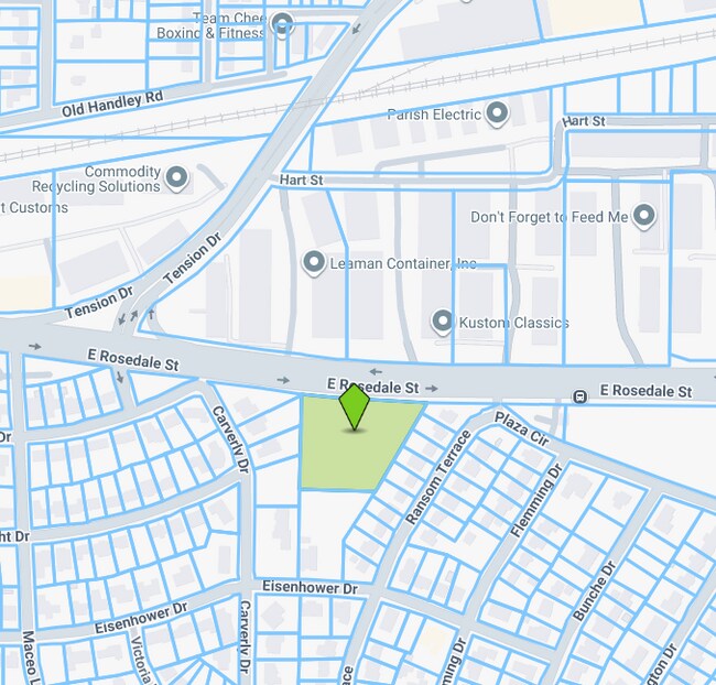
Property Record
5720 E Rosedale St, Fort Worth, TX 76112
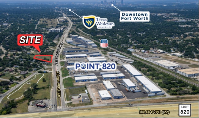

This Property Is For Sale
Current Lease Availabilities
Property Detail
5720 E Rosedale St
Dallas-Fort Worth-Arlington, TX
CARVER HEIGHTS BLOCK Z LOT 13R LESS ROW
00440191
TARRANT
Residentialacreage
Texas
B and X Area of moderate flood hazard, usually the area between the limits of the 100-year and 500-year floods.
13r
2025
2 AC
2025
Southeast Ft Worth
106502
Dallas/Ft Worth
NEARBY LISTINGS FOR SALE OR LEASE
DEMOGRAPHICS near 5720 E Rosedale St
1 mile
3 mile
5 mile
2025 Total Population
11,200
99,137
241,715
2030 Population
11,878
104,974
255,261
Pop Growth 2025-2030
+ 6.05%
+ 5.89%
+ 5.60%
Average Age
36
37
37
2025 Total Households
3,708
35,081
86,015
HH Growth 2025-2030
+ 6.18%
+ 6.10%
+ 5.75%
Median Household Inc
$55,854
$54,247
$62,416
Avg Household Size
2.90
2.70
2.70
2025 Avg HH Vehicles
2.00
2.00
2.00
Median Home Value
$143,908
$206,105
$257,227
Median Year Built
1961
1972
1977
Nearby Places
Map Layers
Map Styles
 Street
 Aerial
Layers
 Traffic
 Biking
Places
Listings with unknown addresses are not visible on the map
- Restaurants
- Banks
- Shops
- Fitness
- Groceries
PUBLIC TRANSPORTATION
COMMUTER RAIL
Trinity Lakes Station (TRINITY RAILWAY - Dallas Area Rapid Transit (DART))
Drive
Walk
Distance
Trinity Lakes Station (TRINITY RAILWAY - Dallas Area Rapid Transit (DART))
10 min
6.5 mi
Fort Worth Intermodal Transit Center (TRINITY RAILWAY - Dallas Area Rapid Transit (DART))
Drive
Walk
Distance
Fort Worth Intermodal Transit Center (TRINITY RAILWAY - Dallas Area Rapid Transit (DART))
12 min
6.7 mi
AIRPORT
Dallas-Fort Worth International
Drive
Walk
Distance
Dallas-Fort Worth International
30 min
22.4 mi
Dallas Love Field
Drive
Walk
Distance
Dallas Love Field
41 min
31.1 mi
Freight Ports
Port of Shreveport
Drive
Walk
Distance
Port of Shreveport
243 min
226.7 mi
Nearby Properties
Address
Land Use
TOTAL SIZE
Lot Size
Zoning
Address
Land Use
TOTAL SIZE
Lot Size
Zoning
221,946 SF
31.17 AC
Address
Land Use
TOTAL SIZE
Lot Size
Zoning
578,886 SF
23.05 AC
Address
Land Use
TOTAL SIZE
Lot Size
Zoning
163,000 SF
12.36 AC
Address
Land Use
TOTAL SIZE
Lot Size
Zoning
171,769 SF
4.96 AC
Address
Land Use
TOTAL SIZE
Lot Size
Zoning
388,905 SF
27.61 AC
Address
Land Use
TOTAL SIZE
Lot Size
Zoning
306,524 SF
24.92 AC
Address
Land Use
TOTAL SIZE
Lot Size
Zoning
131,582 SF
10.61 AC
Address
Land Use
TOTAL SIZE
Lot Size
Zoning
228,667 SF
12.17 AC
Address
Land Use
TOTAL SIZE
Lot Size
Zoning
239,360 SF
17.55 AC
Address
Land Use
TOTAL SIZE
Lot Size
Zoning
197,881 SF
9.98 AC
Address
Land Use
TOTAL SIZE
Lot Size
Zoning
190,755 SF
33.09 AC
Address
Land Use
TOTAL SIZE
Lot Size
Zoning
222,978 SF
12.46 AC
Address
Land Use
TOTAL SIZE
Lot Size
Zoning
220,922 SF
15.32 AC
Address
Land Use
TOTAL SIZE
Lot Size
Zoning
133,193 SF
14.56 AC
Address
Land Use
TOTAL SIZE
Lot Size
Zoning
204,636 SF
9.98 AC
Address
Land Use
TOTAL SIZE
Lot Size
Zoning
198,256 SF
7.96 AC
Address
Land Use
TOTAL SIZE
Lot Size
Zoning
196,098 SF
7.95 AC
Address
Land Use
TOTAL SIZE
Lot Size
Zoning
185,804 SF
9.73 AC
Address
Land Use
TOTAL SIZE
Lot Size
Zoning
91,912 SF
10.10 AC
Address
Land Use
TOTAL SIZE
Lot Size
Zoning
178,923 SF
10.67 AC
Address
Land Use
TOTAL SIZE
Lot Size
Zoning
178,773 SF
10 AC
Address
Land Use
TOTAL SIZE
Lot Size
Zoning
208,085 SF
12 AC
Address
Land Use
TOTAL SIZE
Lot Size
Zoning
161,934 SF
9.89 AC
Address
Land Use
TOTAL SIZE
Lot Size
Zoning
167,976 SF
10 AC
Address
Land Use
TOTAL SIZE
Lot Size
Zoning
194,637 SF
13.75 AC
Address
Land Use
TOTAL SIZE
Lot Size
Zoning
209,784 SF
48.86 AC
Address
Land Use
TOTAL SIZE
Lot Size
Zoning
182,272 SF
7.86 AC
Address
Land Use
TOTAL SIZE
Lot Size
Zoning
147,089 SF
7.46 AC
Address
Land Use
TOTAL SIZE
Lot Size
Zoning
85,001 SF
29.35 AC
Address
Land Use
TOTAL SIZE
Lot Size
Zoning
206,220 SF
14.27 AC
The World's #1 Commercial Real Estate Marketplace
Connect with us
© 2026 CoStar Group
The information above has been obtained from sources believed reliable. While we do not doubt its accuracy we have not verified it and make no guarantee, warranty or representation about it. It is your responsibility to independently confirm its accuracy and completeness. Any projections, opinions, assumptions, or estimates used are for example only and do not represent the current or future performance of the property. The value of this transaction to you depends on tax and other factors which should be evaluated by your tax, financial, and legal advisors. You and your advisors should conduct a careful, independent investigation of the property to determine to your satisfaction the suitability of the property for your needs.