Property Record
5720 State Route 19A, Castile, NY 14427
NEARBY LISTINGS FOR SALE OR LEASE
-
-
View all Castile listings for sale on LoopNet.com
Property Detail
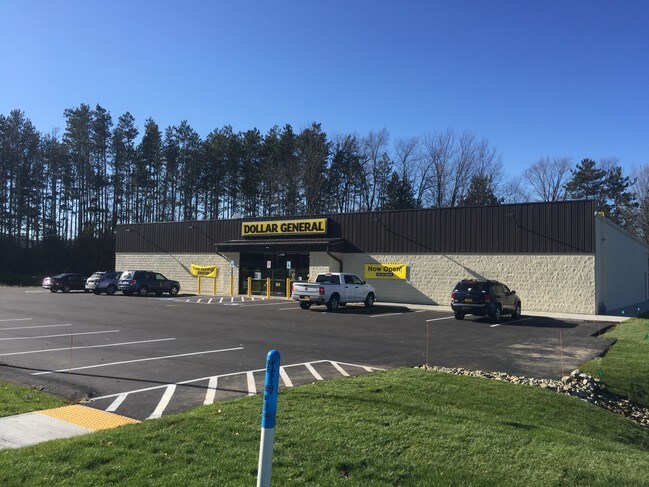
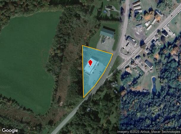
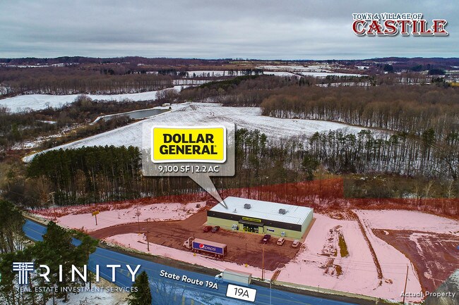
5720 State Route 19A
562601 147.10-1-28.2
Wyoming
Storebuilding
New York
2025
28.002
2024
1.92 AC
970700
New York West Area
9,100 SF
Other Market Areas
DEMOGRAPHICS near 5720 State Route 19A
1 Mile
3 Mile
5 Mile
2024 Total Population
686
2,199
4,023
2029 Population
678
2,164
3,982
Pop Growth 2024-2029
(1.17%)
(1.59%)
(1.02%)
Average Age
40
41
43
2024 Total Households
283
929
1,709
HH Growth 2024-2029
(1.41%)
(1.72%)
(1.11%)
Median Household Inc
$63,446
$61,040
$57,657
Avg Household Size
2.40
2.30
2.30
2024 Avg HH Vehicles
2.00
2.00
2.00
Median Home Value
$112,644
$100,973
$103,040
Median Year Built
1948
1949
1951
Nearby Places
Map Layers
Map Styles
 Street
 Aerial
- Restaurants
- Banks
- Shops
- Fitness
- Groceries
SALE & LEASE HISTORY
LISTING DATE
SALE/LEASE

Jun 25, 2018
For Sale
Dec 10, 2018
For Sale
Nearby Properties
Address
Land Use
TOTAL SIZE
Lot Size
Zoning
Address
Land Use
TOTAL SIZE
Lot Size
Zoning
174,866 SF
165.94 AC
07 - MIXED
Address
Land Use
TOTAL SIZE
Lot Size
Zoning
93.58 AC
05 - COMME
Address
Land Use
TOTAL SIZE
Lot Size
Zoning
5.58 AC
06 - INDUS
Address
Land Use
TOTAL SIZE
Lot Size
Zoning
3.93 AC
02 - SINGL
Address
Land Use
TOTAL SIZE
Lot Size
Zoning
30,000 SF
0.01 AC
05 - COMME
Address
Land Use
TOTAL SIZE
Lot Size
Zoning
2,104 SF
1,639.70 AC
0100
Address
Land Use
TOTAL SIZE
Lot Size
Zoning
477.90 AC
04 - FARM
Address
Land Use
TOTAL SIZE
Lot Size
Zoning
32.62 AC
Address
Land Use
TOTAL SIZE
Lot Size
Zoning
Address
Land Use
TOTAL SIZE
Lot Size
Zoning
20.16 AC
Address
Land Use
TOTAL SIZE
Lot Size
Zoning
2,256 SF
65.22 AC
07 - MIXED
Address
Land Use
TOTAL SIZE
Lot Size
Zoning
Address
Land Use
TOTAL SIZE
Lot Size
Zoning
1,786 SF
126.05 AC
04 - FARM
Address
Land Use
TOTAL SIZE
Lot Size
Zoning
1,956 SF
175.35 AC
04 - FARM
Address
Land Use
TOTAL SIZE
Lot Size
Zoning
Address
Land Use
TOTAL SIZE
Lot Size
Zoning
Address
Land Use
TOTAL SIZE
Lot Size
Zoning
Address
Land Use
TOTAL SIZE
Lot Size
Zoning
4,793 SF
0.19 AC
05
Address
Land Use
TOTAL SIZE
Lot Size
Zoning
10,973 SF
1.11 AC
05 - COMME
Address
Land Use
TOTAL SIZE
Lot Size
Zoning
Address
Land Use
TOTAL SIZE
Lot Size
Zoning
123.87 AC
04 - FARM
Address
Land Use
TOTAL SIZE
Lot Size
Zoning
236.16 AC
Address
Land Use
TOTAL SIZE
Lot Size
Zoning
121.83 AC
04 - FARM
Address
Land Use
TOTAL SIZE
Lot Size
Zoning
3,400 SF
0.33 AC
07 - MIXED
Address
Land Use
TOTAL SIZE
Lot Size
Zoning
211.22 AC
AR
Address
Land Use
TOTAL SIZE
Lot Size
Zoning
97.38 AC
07 - MIXED
Address
Land Use
TOTAL SIZE
Lot Size
Zoning
Address
Land Use
TOTAL SIZE
Lot Size
Zoning
Address
Land Use
TOTAL SIZE
Lot Size
Zoning
112.54 AC
04 - FARM
Address
Land Use
TOTAL SIZE
Lot Size
Zoning
87.87 AC
04 - FARM
The World's #1 Commercial Real Estate Marketplace
Connect with us
© 2026 CoStar Group
The information above has been obtained from sources believed reliable. While we do not doubt its accuracy we have not verified it and make no guarantee, warranty or representation about it. It is your responsibility to independently confirm its accuracy and completeness. Any projections, opinions, assumptions, or estimates used are for example only and do not represent the current or future performance of the property. The value of this transaction to you depends on tax and other factors which should be evaluated by your tax, financial, and legal advisors. You and your advisors should conduct a careful, independent investigation of the property to determine to your satisfaction the suitability of the property for your needs.