Property Record
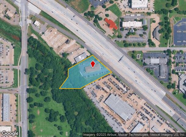
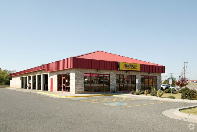
5720 Tinker Diagonal, Oklahoma City, OK 73110

NEARBY LISTINGS FOR SALE OR LEASE
Property Detail
5720 Tinker Diagonal
Oklahoma City, OK
Aviation Acres Sub
150781980
AVIATION ACRES SUB 000 000 PT LOTS 37 & 38 BEG SW/C LOT 37 TH E210.86FT NE378.4FT NW185.35FT NW ALONG CURVE LEFT 77.17FT SW275.14FT S93.02FT SW159.81FT TO BEG
Autorepair
Oklahoma
AE
Oklahoma
40109C0310H
37,38
2023
2.19 AC
2024
East Oklahoma County
107601
Oklahoma City
8,400 SF
DEMOGRAPHICS near 5720 Tinker Diagonal
1 Mile
3 Mile
5 Mile
2024 Total Population
8,631
68,785
134,610
2029 Population
8,819
71,122
139,091
Pop Growth 2024-2029
+ 2.18%
+ 3.40%
+ 3.33%
Average Age
38
36
37
2024 Total Households
3,696
27,355
53,206
HH Growth 2024-2029
+ 2.22%
+ 3.17%
+ 3.28%
Median Household Inc
$41,714
$49,185
$48,436
Avg Household Size
2.20
2.40
2.40
2024 Avg HH Vehicles
2.00
2.00
2.00
Median Home Value
$84,400
$108,190
$121,599
Median Year Built
1963
1969
1972
Nearby Places
Map Layers
Map Styles
 Street
 Aerial
- Restaurants
- Banks
- Shops
- Fitness
- Groceries
PUBLIC TRANSPORTATION
COMMUTER RAIL
Oklahoma City (Heartland Flyer - Amtrak)
DRIVE
WALK
Distance
Oklahoma City (Heartland Flyer - Amtrak)
9 min
6.3 mi
AIRPORT
Will Rogers World
DRIVE
WALK
Distance
Will Rogers World
27 min
15.7 mi
Freight Ports
Tulsa Port Of Catoosa
DRIVE
WALK
Distance
Tulsa Port Of Catoosa
135 min
124.4 mi
Nearby Properties
Address
Land Use
TOTAL SIZE
Lot Size
Zoning
Address
Land Use
TOTAL SIZE
Lot Size
Zoning
320,100 SF
10.41 AC
I-2
Address
Land Use
TOTAL SIZE
Lot Size
Zoning
318,692 SF
15.25 AC
Address
Land Use
TOTAL SIZE
Lot Size
Zoning
200,784 SF
9.28 AC
I-2
Address
Land Use
TOTAL SIZE
Lot Size
Zoning
20,670 SF
3.56 AC
Address
Land Use
TOTAL SIZE
Lot Size
Zoning
78,452 SF
5.19 AC
I-2
Address
Land Use
TOTAL SIZE
Lot Size
Zoning
142,772 SF
11.07 AC
Address
Land Use
TOTAL SIZE
Lot Size
Zoning
242,484 SF
13.18 AC
Address
Land Use
TOTAL SIZE
Lot Size
Zoning
95,330 SF
25.68 AC
Address
Land Use
TOTAL SIZE
Lot Size
Zoning
141,387 SF
41 AC
PUD
Address
Land Use
TOTAL SIZE
Lot Size
Zoning
431,366 SF
17.57 AC
Address
Land Use
TOTAL SIZE
Lot Size
Zoning
10,050 SF
0.79 AC
Address
Land Use
TOTAL SIZE
Lot Size
Zoning
84,940 SF
9.58 AC
Address
Land Use
TOTAL SIZE
Lot Size
Zoning
90,798 SF
11.07 AC
Address
Land Use
TOTAL SIZE
Lot Size
Zoning
119,916 SF
15.06 AC
I-3
Address
Land Use
TOTAL SIZE
Lot Size
Zoning
100,000 SF
11.18 AC
I-2
Address
Land Use
TOTAL SIZE
Lot Size
Zoning
203,263 SF
45.46 AC
Address
Land Use
TOTAL SIZE
Lot Size
Zoning
14,992 SF
1.34 AC
Address
Land Use
TOTAL SIZE
Lot Size
Zoning
124,997 SF
9.80 AC
Address
Land Use
TOTAL SIZE
Lot Size
Zoning
126,556 SF
6.74 AC
R-4
Address
Land Use
TOTAL SIZE
Lot Size
Zoning
145,328 SF
14.95 AC
R-4
Address
Land Use
TOTAL SIZE
Lot Size
Zoning
209,552 SF
11.67 AC
R-4
Address
Land Use
TOTAL SIZE
Lot Size
Zoning
35,245 SF
2.60 AC
Address
Land Use
TOTAL SIZE
Lot Size
Zoning
171,622 SF
9.74 AC
Address
Land Use
TOTAL SIZE
Lot Size
Zoning
8,811 SF
1.73 AC
Address
Land Use
TOTAL SIZE
Lot Size
Zoning
109,637 SF
10.14 AC
I-2
Address
Land Use
TOTAL SIZE
Lot Size
Zoning
164,256 SF
8.38 AC
R-4
Address
Land Use
TOTAL SIZE
Lot Size
Zoning
94,261 SF
13.12 AC
Address
Land Use
TOTAL SIZE
Lot Size
Zoning
180,937 SF
9.92 AC
I-3
Address
Land Use
TOTAL SIZE
Lot Size
Zoning
54,338 SF
10.24 AC
Address
Land Use
TOTAL SIZE
Lot Size
Zoning
81,960 SF
8.12 AC
The World's #1 Commercial Real Estate Marketplace
Connect with us
© 2025 CoStar Group
The information above has been obtained from sources believed reliable. While we do not doubt its accuracy we have not verified it and make no guarantee, warranty or representation about it. It is your responsibility to independently confirm its accuracy and completeness. Any projections, opinions, assumptions, or estimates used are for example only and do not represent the current or future performance of the property. The value of this transaction to you depends on tax and other factors which should be evaluated by your tax, financial, and legal advisors. You and your advisors should conduct a careful, independent investigation of the property to determine to your satisfaction the suitability of the property for your needs.