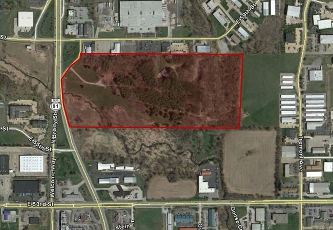
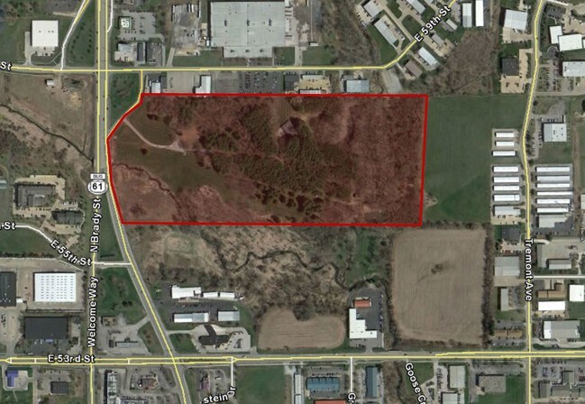
Property Record
5725 N Brady St, Davenport, IA 52806
NEARBY LISTINGS FOR SALE OR LEASE
Property Detail
5725 N Brady St
X1201-04C
Section 12
Apartment
SEC:12 TWP:78 RNG:03PT NW 1/4 COM 13.37 CHS S OF NW COR SEC 12-TH E 40 CHS TO 1/4 SEC LINE-TH S 13.35 CHS-TH W 40 CHS TO
AE
Scott
19163C0355H
Iowa
0
40.34 AC
2025
Greater Davenport
012801
Davenport/Moline/Rock Island
27,225 SF
Davenport-Moline-Rock Island, IA-IL
DEMOGRAPHICS near 5725 N Brady St
1 Mile
3 Mile
5 Mile
2024 Total Population
6,494
57,202
128,351
2029 Population
6,526
56,843
127,726
Pop Growth 2024-2029
+ 0.49%
(0.63%)
(0.49%)
Average Age
36
40
40
2024 Total Households
2,780
23,935
53,789
HH Growth 2024-2029
+ 0.18%
(0.72%)
(0.50%)
Median Household Inc
$51,929
$61,726
$59,828
Avg Household Size
2.20
2.30
2.30
2024 Avg HH Vehicles
2.00
2.00
2.00
Median Home Value
$173,642
$174,213
$174,579
Median Year Built
1990
1973
1969
Nearby Places
Map Layers
Map Styles
 Street
 Aerial
- Restaurants
- Banks
- Shops
- Fitness
- Groceries
PUBLIC TRANSPORTATION
AIRPORT
Quad Cities International
DRIVE
WALK
Distance
Quad Cities International
29 min
14.2 mi
Freight Ports
Port Milwaukee
DRIVE
WALK
Distance
Port Milwaukee
239 min
211.2 mi
SALE & LEASE HISTORY
LISTING DATE
SALE/LEASE

Sep 24, 2016
For Sale
Nearby Properties
Address
Land Use
TOTAL SIZE
Lot Size
Zoning
Address
Land Use
TOTAL SIZE
Lot Size
Zoning
7,934 SF
8.41 AC
Address
Land Use
TOTAL SIZE
Lot Size
Zoning
2,615,134 SF
120.68 AC
Address
Land Use
TOTAL SIZE
Lot Size
Zoning
3,516 SF
26.74 AC
Address
Land Use
TOTAL SIZE
Lot Size
Zoning
157,587 SF
33.92 AC
Address
Land Use
TOTAL SIZE
Lot Size
Zoning
92,431 SF
40.01 AC
Address
Land Use
TOTAL SIZE
Lot Size
Zoning
128,100 SF
14.65 AC
Address
Land Use
TOTAL SIZE
Lot Size
Zoning
45,602 SF
149.61 AC
Address
Land Use
TOTAL SIZE
Lot Size
Zoning
27,306 SF
50.57 AC
Address
Land Use
TOTAL SIZE
Lot Size
Zoning
300,718 SF
14.71 AC
Address
Land Use
TOTAL SIZE
Lot Size
Zoning
63,359 SF
12.01 AC
Address
Land Use
TOTAL SIZE
Lot Size
Zoning
472,569 SF
47.24 AC
Address
Land Use
TOTAL SIZE
Lot Size
Zoning
12,500 SF
578.76 AC
Address
Land Use
TOTAL SIZE
Lot Size
Zoning
123,823 SF
6.46 AC
Address
Land Use
TOTAL SIZE
Lot Size
Zoning
4,944 SF
17.91 AC
Address
Land Use
TOTAL SIZE
Lot Size
Zoning
4,804 SF
202 AC
Address
Land Use
TOTAL SIZE
Lot Size
Zoning
25,176 SF
13.85 AC
Address
Land Use
TOTAL SIZE
Lot Size
Zoning
26,472 SF
17.67 AC
Address
Land Use
TOTAL SIZE
Lot Size
Zoning
77,187 SF
0.88 AC
Address
Land Use
TOTAL SIZE
Lot Size
Zoning
27,312 SF
15.04 AC
Address
Land Use
TOTAL SIZE
Lot Size
Zoning
70,098 SF
9.72 AC
Address
Land Use
TOTAL SIZE
Lot Size
Zoning
8,000 SF
4.59 AC
Address
Land Use
TOTAL SIZE
Lot Size
Zoning
156,632 SF
17.67 AC
Address
Land Use
TOTAL SIZE
Lot Size
Zoning
71,820 SF
5.71 AC
Address
Land Use
TOTAL SIZE
Lot Size
Zoning
197,946 SF
18.64 AC
Address
Land Use
TOTAL SIZE
Lot Size
Zoning
4,800 SF
18.86 AC
Address
Land Use
TOTAL SIZE
Lot Size
Zoning
84,002 SF
21.76 AC
Address
Land Use
TOTAL SIZE
Lot Size
Zoning
4,958 SF
15.49 AC
Address
Land Use
TOTAL SIZE
Lot Size
Zoning
99,540 SF
10.95 AC
Address
Land Use
TOTAL SIZE
Lot Size
Zoning
115,968 SF
2.93 AC
The World's #1 Commercial Real Estate Marketplace
Connect with us
© 2025 CoStar Group
The information above has been obtained from sources believed reliable. While we do not doubt its accuracy we have not verified it and make no guarantee, warranty or representation about it. It is your responsibility to independently confirm its accuracy and completeness. Any projections, opinions, assumptions, or estimates used are for example only and do not represent the current or future performance of the property. The value of this transaction to you depends on tax and other factors which should be evaluated by your tax, financial, and legal advisors. You and your advisors should conduct a careful, independent investigation of the property to determine to your satisfaction the suitability of the property for your needs.