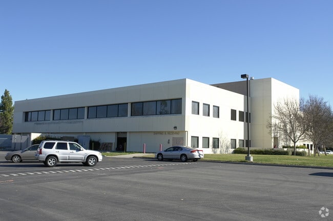
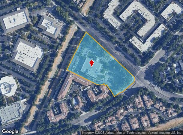
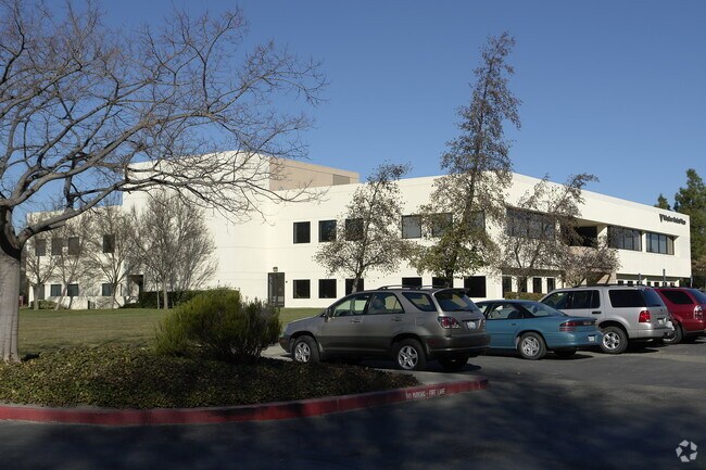
Property Record
5725 W Las Positas Blvd, Pleasanton, CA 94588

NEARBY LISTINGS FOR SALE OR LEASE
Property Detail
5725 W Las Positas Blvd
941-2764-014-00
LOT: 00002 BLK: 0004 AR: 0097 PAGE: 0085 ;LOT: 0000A BLK: PM: 0191 PAGE: 0051 ;LOT: 0000B BLK: PM: 0191 PAGE: 0051
Medicalbuilding
Alameda
X
California
06001C0309G
4.97 AC
2025
Pleasanton
2025
East Bay/Oakland
450743
Oakland-Hayward-Berkeley, CA
60,673 SF
DEMOGRAPHICS near 5725 W Las Positas Blvd
1 Mile
3 Mile
5 Mile
2024 Total Population
17,157
116,300
173,563
2029 Population
16,547
112,725
168,631
Pop Growth 2024-2029
(3.56%)
(3.07%)
(2.84%)
Average Age
38
39
39
2024 Total Households
6,024
40,209
58,811
HH Growth 2024-2029
(3.82%)
(3.22%)
(3.01%)
Median Household Inc
$157,280
$167,779
$178,657
Avg Household Size
2.80
2.80
2.80
2024 Avg HH Vehicles
2.00
2.00
2.00
Median Home Value
$1,078,995
$1,077,100
$1,078,553
Median Year Built
1987
1990
1990
Nearby Places
Map Layers
Map Styles
 Street
 Aerial
- Restaurants
- Banks
- Shops
- Fitness
- Groceries
PUBLIC TRANSPORTATION
COMMUTER RAIL
Pleasanton (Altamont Corridor Express - Altamont Commuter Express (ACE))
DRIVE
WALK
Distance
Pleasanton (Altamont Corridor Express - Altamont Commuter Express (ACE))
8 min
3.0 mi
DRIVE
WALK
Distance
9 min
3.1 mi
AIRPORT
Metro Oakland International
DRIVE
WALK
Distance
Metro Oakland International
29 min
21.4 mi
Norman Y Mineta San Jose International
DRIVE
WALK
Distance
Norman Y Mineta San Jose International
40 min
30.8 mi
San Francisco International
DRIVE
WALK
Distance
San Francisco International
49 min
36.0 mi
Nearby Properties
Address
Land Use
TOTAL SIZE
Lot Size
Zoning
Address
Land Use
TOTAL SIZE
Lot Size
Zoning
641,041 SF
28.76 AC
Address
Land Use
TOTAL SIZE
Lot Size
Zoning
789,398 SF
57.91 AC
Address
Land Use
TOTAL SIZE
Lot Size
Zoning
713,970 SF
23.48 AC
Address
Land Use
TOTAL SIZE
Lot Size
Zoning
674,847 SF
31.27 AC
Address
Land Use
TOTAL SIZE
Lot Size
Zoning
402,824 SF
7.60 AC
Address
Land Use
TOTAL SIZE
Lot Size
Zoning
438,210 SF
17.81 AC
Address
Land Use
TOTAL SIZE
Lot Size
Zoning
249,319 SF
14.72 AC
Address
Land Use
TOTAL SIZE
Lot Size
Zoning
386,609 SF
33.36 AC
Address
Land Use
TOTAL SIZE
Lot Size
Zoning
486,976 SF
11.96 AC
Address
Land Use
TOTAL SIZE
Lot Size
Zoning
153,503 SF
5.22 AC
Address
Land Use
TOTAL SIZE
Lot Size
Zoning
690,205 SF
20.44 AC
Address
Land Use
TOTAL SIZE
Lot Size
Zoning
312,669 SF
3.63 AC
Address
Land Use
TOTAL SIZE
Lot Size
Zoning
402,824 SF
3.68 AC
Address
Land Use
TOTAL SIZE
Lot Size
Zoning
381,982 SF
17.54 AC
Address
Land Use
TOTAL SIZE
Lot Size
Zoning
196,986 SF
7 AC
Address
Land Use
TOTAL SIZE
Lot Size
Zoning
306,815 SF
8.28 AC
Address
Land Use
TOTAL SIZE
Lot Size
Zoning
335,523 SF
7.23 AC
Address
Land Use
TOTAL SIZE
Lot Size
Zoning
465,558 SF
14.56 AC
Address
Land Use
TOTAL SIZE
Lot Size
Zoning
393,931 SF
22.38 AC
Address
Land Use
TOTAL SIZE
Lot Size
Zoning
210,656 SF
11.36 AC
Address
Land Use
TOTAL SIZE
Lot Size
Zoning
315,764 SF
3 AC
Address
Land Use
TOTAL SIZE
Lot Size
Zoning
288,690 SF
0.10 AC
Address
Land Use
TOTAL SIZE
Lot Size
Zoning
176,218 SF
6.39 AC
Address
Land Use
TOTAL SIZE
Lot Size
Zoning
239,112 SF
10.95 AC
Address
Land Use
TOTAL SIZE
Lot Size
Zoning
314,328 SF
2.91 AC
Address
Land Use
TOTAL SIZE
Lot Size
Zoning
209,221 SF
7.16 AC
Address
Land Use
TOTAL SIZE
Lot Size
Zoning
199,932 SF
9.93 AC
Address
Land Use
TOTAL SIZE
Lot Size
Zoning
315,225 SF
10.13 AC
Address
Land Use
TOTAL SIZE
Lot Size
Zoning
300,597 SF
19.34 AC
Address
Land Use
TOTAL SIZE
Lot Size
Zoning
8,000 SF
58.49 AC
The World's #1 Commercial Real Estate Marketplace
Connect with us
© 2026 CoStar Group
The information above has been obtained from sources believed reliable. While we do not doubt its accuracy we have not verified it and make no guarantee, warranty or representation about it. It is your responsibility to independently confirm its accuracy and completeness. Any projections, opinions, assumptions, or estimates used are for example only and do not represent the current or future performance of the property. The value of this transaction to you depends on tax and other factors which should be evaluated by your tax, financial, and legal advisors. You and your advisors should conduct a careful, independent investigation of the property to determine to your satisfaction the suitability of the property for your needs.