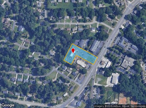
Property Record
573 Concord Rd Se, Smyrna, GA 30082
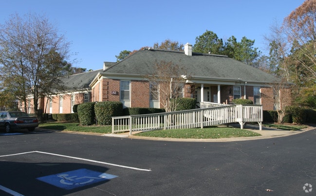
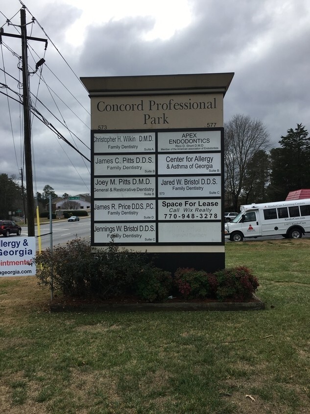
This Property Is For Sale
Current Lease Availabilities
NEARBY LISTINGS FOR SALE OR LEASE
Property Detail
573 Concord Rd Se
Officebuilding
Cobb
X
Georgia
13067C0206J
1.38 AC
2025
Cumberland/Galleria
2025
Atlanta
031115
Atlanta-Sandy Springs-Roswell, GA
7,494 SF
17-0339-0-053-0
DEMOGRAPHICS near 573 Concord Rd Se
1 Mile
3 Mile
5 Mile
2024 Total Population
9,904
93,410
236,621
2029 Population
10,029
94,969
241,624
Pop Growth 2024-2029
+ 1.26%
+ 1.67%
+ 2.11%
Average Age
38
37
37
2024 Total Households
3,820
37,101
99,560
HH Growth 2024-2029
+ 1.26%
+ 1.63%
+ 2.10%
Median Household Inc
$103,005
$82,488
$77,359
Avg Household Size
2.50
2.40
2.30
2024 Avg HH Vehicles
2.00
2.00
2.00
Median Home Value
$368,210
$354,149
$332,562
Median Year Built
1979
1984
1987
Nearby Places
Map Layers
Map Styles
 Street
 Aerial
- Restaurants
- Banks
- Shops
- Fitness
- Groceries
PUBLIC TRANSPORTATION
AIRPORT
Hartsfield - Jackson Atlanta International
DRIVE
WALK
Distance
Hartsfield - Jackson Atlanta International
38 min
24.3 mi
Nearby Properties
Address
Land Use
TOTAL SIZE
Lot Size
Zoning
Address
Land Use
TOTAL SIZE
Lot Size
Zoning
389,428 SF
22.50 AC
RM12
Address
Land Use
TOTAL SIZE
Lot Size
Zoning
504,744 SF
44.36 AC
RM-12
Address
Land Use
TOTAL SIZE
Lot Size
Zoning
357,031 SF
10.69 AC
MU
Address
Land Use
TOTAL SIZE
Lot Size
Zoning
285,395 SF
26.58 AC
RM-12
Address
Land Use
TOTAL SIZE
Lot Size
Zoning
374,698 SF
30.72 AC
RM-12
Address
Land Use
TOTAL SIZE
Lot Size
Zoning
477,544 SF
4.61 AC
MU
Address
Land Use
TOTAL SIZE
Lot Size
Zoning
370,201 SF
28.35 AC
RM-12
Address
Land Use
TOTAL SIZE
Lot Size
Zoning
488,748 SF
32.28 AC
RM-12
Address
Land Use
TOTAL SIZE
Lot Size
Zoning
230,032 SF
19.77 AC
RM-16
Address
Land Use
TOTAL SIZE
Lot Size
Zoning
267,021 SF
13.72 AC
RM-16
Address
Land Use
TOTAL SIZE
Lot Size
Zoning
698,904 SF
36.69 AC
HI
Address
Land Use
TOTAL SIZE
Lot Size
Zoning
237,498 SF
29.95 AC
RM-12
Address
Land Use
TOTAL SIZE
Lot Size
Zoning
257,852 SF
15.13 AC
RHR
Address
Land Use
TOTAL SIZE
Lot Size
Zoning
148,612 SF
12.65 AC
RM-12
Address
Land Use
TOTAL SIZE
Lot Size
Zoning
204,595 SF
15.88 AC
RM-12
Address
Land Use
TOTAL SIZE
Lot Size
Zoning
138,264 SF
9.28 AC
RM-12
Address
Land Use
TOTAL SIZE
Lot Size
Zoning
345,192 SF
22.67 AC
RM-12
Address
Land Use
TOTAL SIZE
Lot Size
Zoning
187,972 SF
11.94 AC
RM-12
Address
Land Use
TOTAL SIZE
Lot Size
Zoning
172,300 SF
15.80 AC
RM-12
Address
Land Use
TOTAL SIZE
Lot Size
Zoning
191,400 SF
25.70 AC
LI
Address
Land Use
TOTAL SIZE
Lot Size
Zoning
160,030 SF
13.38 AC
RM-12
Address
Land Use
TOTAL SIZE
Lot Size
Zoning
150,440 SF
25 AC
LI
Address
Land Use
TOTAL SIZE
Lot Size
Zoning
377,059 SF
32.20 AC
LI
Address
Land Use
TOTAL SIZE
Lot Size
Zoning
203,803 SF
14.63 AC
RM-12
Address
Land Use
TOTAL SIZE
Lot Size
Zoning
289,582 SF
21.01 AC
RM-12
Address
Land Use
TOTAL SIZE
Lot Size
Zoning
132,810 SF
9.50 AC
RM-12
Address
Land Use
TOTAL SIZE
Lot Size
Zoning
425,800 SF
32.52 AC
HI
Address
Land Use
TOTAL SIZE
Lot Size
Zoning
94,230 SF
12.47 AC
GC
Address
Land Use
TOTAL SIZE
Lot Size
Zoning
250,482 SF
16.74 AC
RM-12
Address
Land Use
TOTAL SIZE
Lot Size
Zoning
145,185 SF
13.52 AC
RM-12
The World's #1 Commercial Real Estate Marketplace
Connect with us
© 2026 CoStar Group
The information above has been obtained from sources believed reliable. While we do not doubt its accuracy we have not verified it and make no guarantee, warranty or representation about it. It is your responsibility to independently confirm its accuracy and completeness. Any projections, opinions, assumptions, or estimates used are for example only and do not represent the current or future performance of the property. The value of this transaction to you depends on tax and other factors which should be evaluated by your tax, financial, and legal advisors. You and your advisors should conduct a careful, independent investigation of the property to determine to your satisfaction the suitability of the property for your needs.