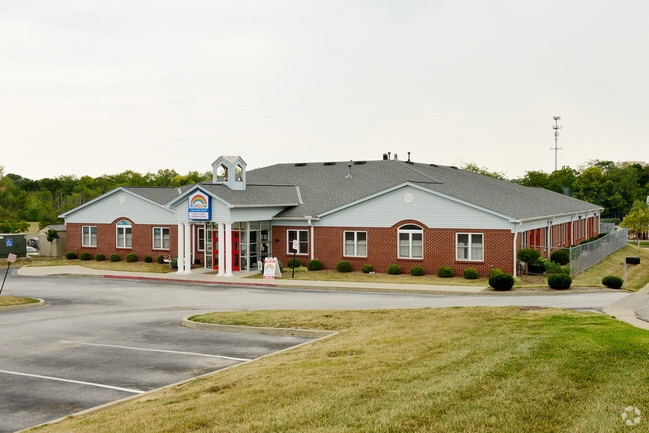
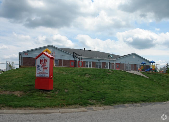
Property Record
573 Freedom Park Dr, Crestview Hills, KY 41017
NEARBY LISTINGS FOR SALE OR LEASE
Property Detail
573 Freedom Park Dr
Cincinnati, OH-KY-IN
St Elizabeth Medical Center
029-20-00-001.16
ST ELIZABETH MED CENTER SEC 1 LOT 2
Daycare
Kenton
X
Kentucky
21037C0025E
2
2025
0.75 AC
2025
Cincinnati Intl Airport
064600
Cincinnati/Dayton
10,490 SF
DEMOGRAPHICS near 573 Freedom Park Dr
1 Mile
3 Mile
5 Mile
2024 Total Population
6,210
54,524
148,876
2029 Population
6,318
55,545
152,844
Pop Growth 2024-2029
+ 1.74%
+ 1.87%
+ 2.67%
Average Age
42
39
39
2024 Total Households
2,251
21,174
59,003
HH Growth 2024-2029
+ 1.82%
+ 1.84%
+ 2.68%
Median Household Inc
$110,883
$82,327
$69,922
Avg Household Size
2.50
2.50
2.40
2024 Avg HH Vehicles
2.00
2.00
2.00
Median Home Value
$282,694
$227,812
$210,385
Median Year Built
1979
1977
1976
Nearby Places
Map Layers
Map Styles
 Street
 Aerial
- Restaurants
- Banks
- Shops
- Fitness
- Groceries
PUBLIC TRANSPORTATION
COMMUTER RAIL
Cincinnati Union Terminal (Cardinal - Amtrak)
DRIVE
WALK
Distance
Cincinnati Union Terminal (Cardinal - Amtrak)
19 min
9.5 mi
AIRPORT
Cincinnati/Northern Kentucky International
DRIVE
WALK
Distance
Cincinnati/Northern Kentucky International
21 min
8.9 mi
Freight Ports
Port of Toledo
DRIVE
WALK
Distance
Port of Toledo
255 min
214.1 mi
Nearby Properties
Address
Land Use
TOTAL SIZE
Lot Size
Zoning
Address
Land Use
TOTAL SIZE
Lot Size
Zoning
Address
Land Use
TOTAL SIZE
Lot Size
Zoning
Address
Land Use
TOTAL SIZE
Lot Size
Zoning
19.61 AC
Address
Land Use
TOTAL SIZE
Lot Size
Zoning
25.08 AC
Address
Land Use
TOTAL SIZE
Lot Size
Zoning
475,250 SF
37.16 AC
Address
Land Use
TOTAL SIZE
Lot Size
Zoning
13.62 AC
Address
Land Use
TOTAL SIZE
Lot Size
Zoning
1,170 SF
41.17 AC
Address
Land Use
TOTAL SIZE
Lot Size
Zoning
441,907 SF
Address
Land Use
TOTAL SIZE
Lot Size
Zoning
12.85 AC
Address
Land Use
TOTAL SIZE
Lot Size
Zoning
Address
Land Use
TOTAL SIZE
Lot Size
Zoning
30.11 AC
Address
Land Use
TOTAL SIZE
Lot Size
Zoning
24.80 AC
Address
Land Use
TOTAL SIZE
Lot Size
Zoning
24.28 AC
Address
Land Use
TOTAL SIZE
Lot Size
Zoning
57,030 SF
7 AC
Address
Land Use
TOTAL SIZE
Lot Size
Zoning
12.60 AC
Address
Land Use
TOTAL SIZE
Lot Size
Zoning
Address
Land Use
TOTAL SIZE
Lot Size
Zoning
176,588 SF
24.35 AC
Address
Land Use
TOTAL SIZE
Lot Size
Zoning
Address
Land Use
TOTAL SIZE
Lot Size
Zoning
25.96 AC
Address
Land Use
TOTAL SIZE
Lot Size
Zoning
179,770 SF
Address
Land Use
TOTAL SIZE
Lot Size
Zoning
Address
Land Use
TOTAL SIZE
Lot Size
Zoning
180,972 SF
Address
Land Use
TOTAL SIZE
Lot Size
Zoning
183,917 SF
24.93 AC
Address
Land Use
TOTAL SIZE
Lot Size
Zoning
145,930 SF
15.65 AC
Address
Land Use
TOTAL SIZE
Lot Size
Zoning
72.43 AC
Address
Land Use
TOTAL SIZE
Lot Size
Zoning
64,039 SF
3.69 AC
Address
Land Use
TOTAL SIZE
Lot Size
Zoning
7.26 AC
Address
Land Use
TOTAL SIZE
Lot Size
Zoning
43,154 SF
9.37 AC
Address
Land Use
TOTAL SIZE
Lot Size
Zoning
180,941 SF
9.23 AC
Address
Land Use
TOTAL SIZE
Lot Size
Zoning
45,000 SF
0.64 AC
The World's #1 Commercial Real Estate Marketplace
Connect with us
© 2025 CoStar Group
The information above has been obtained from sources believed reliable. While we do not doubt its accuracy we have not verified it and make no guarantee, warranty or representation about it. It is your responsibility to independently confirm its accuracy and completeness. Any projections, opinions, assumptions, or estimates used are for example only and do not represent the current or future performance of the property. The value of this transaction to you depends on tax and other factors which should be evaluated by your tax, financial, and legal advisors. You and your advisors should conduct a careful, independent investigation of the property to determine to your satisfaction the suitability of the property for your needs.