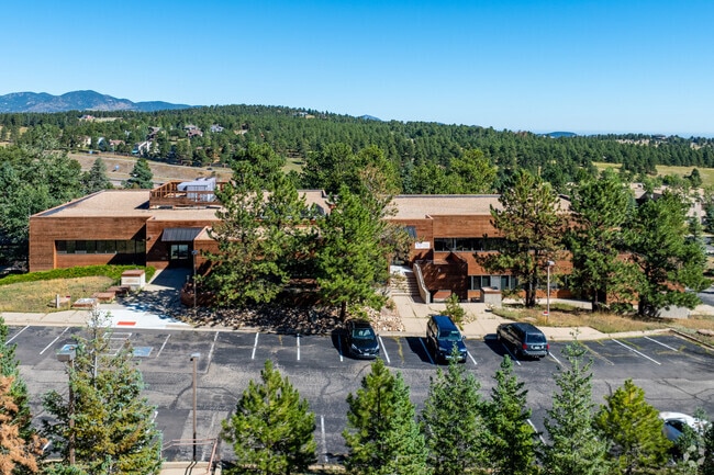
Property Record
573 Park Point Dr, Golden, CO 80401

Property Detail
573 Park Point Dr
41-132-01-008
SECTION 13 TOWNSHIP 04 RANGE 71 QTR N2 SUBDIVISIONCD 276200 SUBDIVISIONNAME GENESEE OFFICE COMMERCIAL FLG #2 L3 & 4 EX SUR BLOCK LOT 0003 SIZE: 184825 TRACT VALUE: 4.243
Commercialnec
JEFFERSON
PD
Colorado
B and X Area of moderate flood hazard, usually the area between the limits of the 100-year and 500-year floods.
3
2025
4.24 AC
2025
West Denver
009845
Denver
25,226 SF
Denver-Aurora-Centennial, CO
NEARBY LISTINGS FOR SALE OR LEASE
DEMOGRAPHICS near 573 Park Point Dr
1 mile
3 mile
5 mile
2025 Total Population
893
6,876
27,953
2030 Population
890
6,845
27,941
Pop Growth 2025-2030
(0.34%)
(0.45%)
(0.04%)
Average Age
49
48
43
2025 Total Households
379
2,849
10,961
HH Growth 2025-2030
(0.53%)
(0.60%)
(0.07%)
Median Household Inc
$178,409
$182,017
$135,784
Avg Household Size
2.30
2.40
2.40
2025 Avg HH Vehicles
2.00
2.00
2.00
Median Home Value
$1,019,565
$1,028,039
$945,491
Median Year Built
1985
1985
1986
Nearby Places
Map Layers
Map Styles
 Street
 Aerial
Transit
 Traffic
 Biking
Places
Listings with unknown addresses are not visible on the map
- Restaurants
- Banks
- Shops
- Fitness
- Groceries
PUBLIC TRANSPORTATION
AIRPORT
Denver International
Drive
Walk
Distance
Denver International
54 min
42.8 mi
SALE & LEASE HISTORY
LISTING DATE
SALE/LEASE

Nov 18, 2022
For Sale
Nov 09, 2022
For Sale
Feb 26, 2024
For Sale
Nearby Properties
Address
Land Use
TOTAL SIZE
Lot Size
Zoning
Address
Land Use
TOTAL SIZE
Lot Size
Zoning
57,775 SF
4.47 AC
Address
Land Use
TOTAL SIZE
Lot Size
Zoning
4,655 SF
566.76 AC
CO
Address
Land Use
TOTAL SIZE
Lot Size
Zoning
160,578 SF
15.07 AC
C1
Address
Land Use
TOTAL SIZE
Lot Size
Zoning
46,955 SF
7.84 AC
PD
Address
Land Use
TOTAL SIZE
Lot Size
Zoning
47,651 SF
5 AC
C1
Address
Land Use
TOTAL SIZE
Lot Size
Zoning
53,739 SF
1.51 AC
MR1
Address
Land Use
TOTAL SIZE
Lot Size
Zoning
82,457 SF
9.38 AC
C1
Address
Land Use
TOTAL SIZE
Lot Size
Zoning
51,200 SF
3.80 AC
PD
Address
Land Use
TOTAL SIZE
Lot Size
Zoning
75,008 SF
2.17 AC
PD
Address
Land Use
TOTAL SIZE
Lot Size
Zoning
31,437 SF
12.36 AC
PD
Address
Land Use
TOTAL SIZE
Lot Size
Zoning
27,303 SF
6.99 AC
PD
Address
Land Use
TOTAL SIZE
Lot Size
Zoning
321.19 AC
C2
Address
Land Use
TOTAL SIZE
Lot Size
Zoning
73,388 SF
9.37 AC
PD
Address
Land Use
TOTAL SIZE
Lot Size
Zoning
36,402 SF
5.64 AC
PD
Address
Land Use
TOTAL SIZE
Lot Size
Zoning
29,748 SF
257.77 AC
Address
Land Use
TOTAL SIZE
Lot Size
Zoning
39,265 SF
6.07 AC
PD
Address
Land Use
TOTAL SIZE
Lot Size
Zoning
7,584 SF
58 AC
CO
Address
Land Use
TOTAL SIZE
Lot Size
Zoning
12,322 SF
5.69 AC
Address
Land Use
TOTAL SIZE
Lot Size
Zoning
19,820 SF
4.39 AC
C1
Address
Land Use
TOTAL SIZE
Lot Size
Zoning
51,506 SF
5.50 AC
PD
Address
Land Use
TOTAL SIZE
Lot Size
Zoning
320 AC
A2
Address
Land Use
TOTAL SIZE
Lot Size
Zoning
9,168 SF
9.56 AC
SR5
Address
Land Use
TOTAL SIZE
Lot Size
Zoning
305 AC
A2
Address
Land Use
TOTAL SIZE
Lot Size
Zoning
1,452 SF
687.71 AC
CO
Address
Land Use
TOTAL SIZE
Lot Size
Zoning
24,593 SF
52.38 AC
MR1
Address
Land Use
TOTAL SIZE
Lot Size
Zoning
18,904 SF
6.65 AC
PD
Address
Land Use
TOTAL SIZE
Lot Size
Zoning
4,523 SF
1.60 AC
C1
Address
Land Use
TOTAL SIZE
Lot Size
Zoning
12,898 SF
0.72 AC
PD
Address
Land Use
TOTAL SIZE
Lot Size
Zoning
3,936 SF
1.46 AC
C1
Address
Land Use
TOTAL SIZE
Lot Size
Zoning
233.98 AC
A2
The World's #1 Commercial Real Estate Marketplace
Connect with us
© 2026 CoStar Group
The information above has been obtained from sources believed reliable. While we do not doubt its accuracy we have not verified it and make no guarantee, warranty or representation about it. It is your responsibility to independently confirm its accuracy and completeness. Any projections, opinions, assumptions, or estimates used are for example only and do not represent the current or future performance of the property. The value of this transaction to you depends on tax and other factors which should be evaluated by your tax, financial, and legal advisors. You and your advisors should conduct a careful, independent investigation of the property to determine to your satisfaction the suitability of the property for your needs.