Property Record
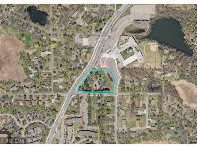
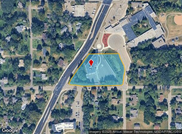
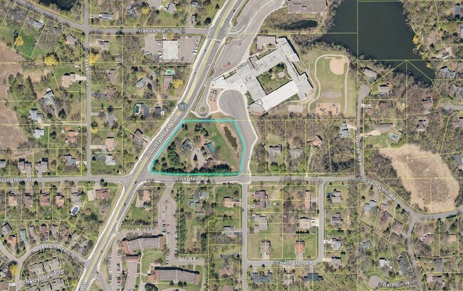
5735 County Road 101 Rd N, Minnetonka, MN 55345
NEARBY LISTINGS FOR SALE OR LEASE
Property Detail
5735 County Road 101 Rd N
Minneapolis-St. Paul-Bloomington, MN-WI
Covington Woods
31-117-22-13-0035
LOT 005 BLOCK 001 A COVINGTON WOODS THAT PART OF LOT 5, WHICH LIES WESTERLY OF THE FOLLOWING DESCRIBED LINE 1: COMMENCING AT THE SOUTHEAST CORNER OF SAID LOT 5; THENCE WESTERLY T IRREGULAR
Commercialnec
Hennepin
X
Minnesota
27019C0119D
5
0
2.85 AC
2024
I-394 Corridor
026207
Minneapolis/St Paul
1,748 SF
DEMOGRAPHICS near 5735 County Road 101 Rd N
1 Mile
3 Mile
5 Mile
2024 Total Population
6,917
51,353
120,807
2029 Population
6,787
51,098
121,002
Pop Growth 2024-2029
(1.88%)
(0.50%)
+ 0.16%
Average Age
41
43
42
2024 Total Households
2,727
20,010
48,440
HH Growth 2024-2029
(2.05%)
(0.57%)
+ 0.07%
Median Household Inc
$122,781
$121,038
$114,564
Avg Household Size
2.50
2.50
2.40
2024 Avg HH Vehicles
2.00
2.00
2.00
Median Home Value
$436,673
$446,682
$457,040
Median Year Built
1981
1980
1983
Nearby Places
Map Layers
Map Styles
 Street
 Aerial
- Restaurants
- Banks
- Shops
- Fitness
- Groceries
PUBLIC TRANSPORTATION
AIRPORT
Minneapolis-St Paul International/Wold-Chamberlain
DRIVE
WALK
Distance
Minneapolis-St Paul International/Wold-Chamberlain
27 min
18.0 mi
Freight Ports
Port Milwaukee
DRIVE
WALK
Distance
Port Milwaukee
395 min
353.2 mi
SALE & LEASE HISTORY
LISTING DATE
SALE/LEASE

Aug 28, 2019
For Sale
Nearby Properties
Address
Land Use
TOTAL SIZE
Lot Size
Zoning
Address
Land Use
TOTAL SIZE
Lot Size
Zoning
46,726 SF
2.65 AC
PUD
Address
Land Use
TOTAL SIZE
Lot Size
Zoning
1.11 AC
Address
Land Use
TOTAL SIZE
Lot Size
Zoning
3,073 SF
155.36 AC
Address
Land Use
TOTAL SIZE
Lot Size
Zoning
20.18 AC
RM65
Address
Land Use
TOTAL SIZE
Lot Size
Zoning
7.06 AC
PUD
Address
Land Use
TOTAL SIZE
Lot Size
Zoning
7,209 SF
2.53 AC
B1
Address
Land Use
TOTAL SIZE
Lot Size
Zoning
47,443 SF
10.11 AC
RM25
Address
Land Use
TOTAL SIZE
Lot Size
Zoning
1.85 AC
Address
Land Use
TOTAL SIZE
Lot Size
Zoning
29,091 SF
34.94 AC
PUD
Address
Land Use
TOTAL SIZE
Lot Size
Zoning
7.82 AC
R4
Address
Land Use
TOTAL SIZE
Lot Size
Zoning
17.67 AC
R4
Address
Land Use
TOTAL SIZE
Lot Size
Zoning
9.29 AC
R4
Address
Land Use
TOTAL SIZE
Lot Size
Zoning
88,948 SF
10.14 AC
B2
Address
Land Use
TOTAL SIZE
Lot Size
Zoning
14.04 AC
R4
Address
Land Use
TOTAL SIZE
Lot Size
Zoning
85,425 SF
8.21 AC
C-COM
Address
Land Use
TOTAL SIZE
Lot Size
Zoning
34,100 SF
12.99 AC
Address
Land Use
TOTAL SIZE
Lot Size
Zoning
38,825 SF
5.38 AC
B3
Address
Land Use
TOTAL SIZE
Lot Size
Zoning
47,485 SF
2.19 AC
PUD
Address
Land Use
TOTAL SIZE
Lot Size
Zoning
16,576 SF
4.84 AC
Address
Land Use
TOTAL SIZE
Lot Size
Zoning
8.49 AC
Address
Land Use
TOTAL SIZE
Lot Size
Zoning
30,970 SF
3.46 AC
Address
Land Use
TOTAL SIZE
Lot Size
Zoning
13.35 AC
Address
Land Use
TOTAL SIZE
Lot Size
Zoning
1,000 SF
14 AC
Address
Land Use
TOTAL SIZE
Lot Size
Zoning
19.47 AC
Address
Land Use
TOTAL SIZE
Lot Size
Zoning
88,205 SF
8.91 AC
Address
Land Use
TOTAL SIZE
Lot Size
Zoning
12,993 SF
2.22 AC
R5
Address
Land Use
TOTAL SIZE
Lot Size
Zoning
Address
Land Use
TOTAL SIZE
Lot Size
Zoning
7.56 AC
Address
Land Use
TOTAL SIZE
Lot Size
Zoning
Address
Land Use
TOTAL SIZE
Lot Size
Zoning
1.67 AC
The World's #1 Commercial Real Estate Marketplace
Connect with us
© 2025 CoStar Group
The information above has been obtained from sources believed reliable. While we do not doubt its accuracy we have not verified it and make no guarantee, warranty or representation about it. It is your responsibility to independently confirm its accuracy and completeness. Any projections, opinions, assumptions, or estimates used are for example only and do not represent the current or future performance of the property. The value of this transaction to you depends on tax and other factors which should be evaluated by your tax, financial, and legal advisors. You and your advisors should conduct a careful, independent investigation of the property to determine to your satisfaction the suitability of the property for your needs.